United States Mountain
Mountain in the state of Colorado


United States Mountain
Location in Colorado
Show map of Colorado
United States Mountain
United States Mountain (the United States)
Show map of the United StatesColorado, US
San Juan Mountains
Sneffels Range[1]
United States Mountain is a 13,036-foot-elevation (3,973-meter) mountain summit located in Ouray County of southwest Colorado, United States.[3] It is situated six miles southwest of the community of Ouray, on land managed by Uncompahgre National Forest. It is part of the Sneffels Range which is a subset of the San Juan Mountains, which in turn is part of the Rocky Mountains. It is set west of the Continental Divide, 2.3 miles south of Potosi Peak, and 2.5 miles southeast of Stony Mountain. Recreation enthusiasts heading for Yankee Boy Basin traverse below the northern base of the mountain. Topographic relief is significant as the north aspect rises 3,300 feet (1,000 meters) above the Camp Bird Mine in approximately one mile. Mining activity in the immediate area produced significant amounts of gold and silver.[4] The Hidden Treasure Mine is a gold mine located on the south slope at 11,759-feet elevation.[5]
Climate
According to the Köppen climate classification system, United States Mountain is located in an alpine subarctic climate zone with long, cold, snowy winters, and cool to warm summers.[6] Due to its altitude, it receives precipitation all year, as snow in winter, and as thunderstorms in summer, with a dry period in late spring. Precipitation runoff from the mountain drains into Canyon Creek which is a tributary of the Uncompahgre River.
Gallery
-
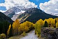 Northeast aspect
 -
 Chicago Peak (left) and United States Mountain (right) viewed from the east.
 -
 South aspect of United States Mountain seen from Imogene Pass.
In back: Teakettle Mountain, Potosi Peak, and Whitehouse Mountain. -
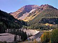 United States Mountain from Camp Bird
 -


See also
 Mountains portal
 Colorado portal


- Mountains of Ouray County, Colorado
References
- ^ a b c "United States Mountain, Colorado". Peakbagger.com.
- ^ a b "United States Mountain - 13,036' CO". listsofjohn.com. Retrieved 2021-07-04.
- ^ a b "United States Mountain". Geographic Names Information System. United States Geological Survey, United States Department of the Interior. Retrieved 2021-07-04.
- ^ Camp Bird Mine, Ouray, Sneffels District (Mount Sneffels District), Ouray Co., Colorado, USA
- ^ Hidden Treasure, Westernmininghistory.com
- ^ Peel, M. C.; Finlayson, B. L.; McMahon, T. A. (2007). "Updated world map of the Köppen−Geiger climate classification". Hydrol. Earth Syst. Sci. 11. ISSN 1027-5606.
External links
- Weather forecast: United States Mountain
- v
- t
- e

- Mount Garfield
- Aspen Mountain
- Capitol Peak
- Castle Peak
- Cathedral Peak
- Chair Mountain
- Crested Butte
- Gothic Mountain
- Italian Mountain
- Maroon Bells
- Mount Emmons
- Mount Owen
- Mount Sopris
- Pyramid Peak
- Snowmass Mountain
- Snowmass Peak
- Treasure Mountain
- Black Mountain (Moffat County)
- Columbus Mountain
- Elk Mountain (Routt County)
- Hahns Peak
- Flat Top Mountain
- Sleepy Cat Peak
- Eagles Nest
- Jacque Peak
- Meridian Peak
- Mount Powell
- The Spider
- Crater Peak
- North Mamm Peak
- Clark Peak
- Arkansas Hills
- Clinton Peak
- Dyer Mountain
- Gemini Peak
- Horseshoe Mountain
- Mount Arkansas
- Mount Bross
- Mount Buckskin
- Mount Democrat
- Mount Lincoln
- Mount Sheridan
- Mount Sherman
- Pacific Peak
- West Buffalo Peak
- Elk Mountain (Grand County)
- Parkview Mountain
- Radial Mountain
- Whiteley Peak
| Sangre de Cristo Range |
|
|---|---|
| Wet Mountains |
|
| Others |
|
| Collegiate Peaks |
|
|---|---|
| Others |
|
- Crystal Peak
- Fletcher Mountain
- Peak 10
- Peak One
- Quandary Peak
- Tenmile Peak
- Bear Mountain
- Blair Mountain
- Chalk Mountains
- Cochetopa Hills
- Dawson Butte
- Diamond Peak
- Flirtation Peak
- Granite Peak
- Grand Hogback
- Grannys Nipple
- Horsefly Peak
- Lead Mountain (Grand County)
- Mount Neva
- Powell Peak
- San Luis Hills
- Storm King Mountain
- Terrible Mountain
- Two Buttes
- Ute Mountain


