Ellingwood Point
Mountain in Colorado, United States


Ellingwood Point
Colorado
Sierra Blanca Massif[2]
Blanca Peak, Colorado[3]
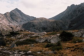
Ellingwood Point is a high mountain summit in the Sangre de Cristo Range of the Rocky Mountains of North America. The 14,048-foot (4,282 m) fourteener is located on the Sierra Blanca Massif, 9.9 miles (16.0 km) north by east (bearing 7°) of the Town of Blanca, Colorado, United States, on the drainage divide separating the Rio Grande National Forest and Alamosa County from the San Isabel National Forest and Huerfano County.[1][2][3] Ellingwood Point was named in honor of Albert Russell Ellingwood, an early pioneer of mountain climbing in the Western United States and in Colorado in particular.
Mountain
Ellingwood Point only barely qualifies as an independent peak under the 300-foot (91 m) topographic prominence cutoff which is standard in Colorado. It is also quite close to its parent peak, Blanca Peak. Hence its inclusion in fourteener lists has been somewhat controversial. However most authorities do consider it a true fourteener.[5]
Names
- Ellingwood Peak
- Ellingwood Point – 1972 [3]

Climate
According to the Köppen climate classification system, the mountain is located in an alpine subarctic climate zone with cold, snowy winters, and cool to warm summers.[6] Due to its altitude, it receives precipitation all year, as snow in winter, and as thunderstorms in summer, with a dry period in late spring.
See also
- List of mountain peaks of Colorado
 Mountains portal
 Colorado portal


References
- ^ a b The elevation of Ellingwood Point includes an adjustment of +1.789 m (+5.87 ft) from NGVD 29 to NAVD 88.
- ^ a b c d e f "Ellingwood Point, Colorado". Peakbagger.com. Retrieved October 20, 2014.
- ^ a b c d e "Ellingwood Point". Geographic Names Information System. United States Geological Survey, United States Department of the Interior. Retrieved October 20, 2014.
- ^ "Ellingwood Point Routes". 14ers.com.
- ^ Louis W. Dawson II (1996). Dawson's Guide to Colorado's Fourteeners, Volume 2. Blue Clover Press. ISBN 0-9628867-2-6.
- ^ Peel, M. C.; Finlayson, B. L.; McMahon, T. A. (2007). "Updated world map of the Köppen−Geiger climate classification". Hydrol. Earth Syst. Sci. 11. ISSN 1027-5606.
External links
Ellingwood Point at Wikipedia's sister projects
 Definitions from Wiktionary
 Media from Commons
 News from Wikinews
 Quotations from Wikiquote
 Texts from Wikisource
 Textbooks from Wikibooks
 Resources from Wikiversity
- "Ellingwood Point". 14ers.com.
- "Ellingwood Point". SummitPost.org. Retrieved 2011-05-15.
- v
- t
- e

- Mount Garfield
- Aspen Mountain
- Capitol Peak
- Castle Peak
- Cathedral Peak
- Chair Mountain
- Crested Butte
- Gothic Mountain
- Italian Mountain
- Maroon Bells
- Mount Emmons
- Mount Owen
- Mount Sopris
- Pyramid Peak
- Snowmass Mountain
- Snowmass Peak
- Treasure Mountain
- Black Mountain (Moffat County)
- Columbus Mountain
- Elk Mountain (Routt County)
- Hahns Peak
- Flat Top Mountain
- Sleepy Cat Peak
- Eagles Nest
- Jacque Peak
- Meridian Peak
- Mount Powell
- The Spider
- Crater Peak
- North Mamm Peak
- Clark Peak
- Arkansas Hills
- Clinton Peak
- Dyer Mountain
- Gemini Peak
- Horseshoe Mountain
- Mount Arkansas
- Mount Bross
- Mount Buckskin
- Mount Democrat
- Mount Lincoln
- Mount Sheridan
- Mount Sherman
- Pacific Peak
- West Buffalo Peak
- Elk Mountain (Grand County)
- Parkview Mountain
- Radial Mountain
- Whiteley Peak
| Sangre de Cristo Range |
|
|---|---|
| Wet Mountains |
|
| Others |
|
| Collegiate Peaks |
|
|---|---|
| Others |
|
- Crystal Peak
- Fletcher Mountain
- Peak 10
- Peak One
- Quandary Peak
- Tenmile Peak
- Bear Mountain
- Blair Mountain
- Chalk Mountains
- Cochetopa Hills
- Dawson Butte
- Diamond Peak
- Flirtation Peak
- Granite Peak
- Grand Hogback
- Grannys Nipple
- Horsefly Peak
- Lead Mountain (Grand County)
- Mount Neva
- Powell Peak
- San Luis Hills
- Storm King Mountain
- Terrible Mountain
- Two Buttes
- Ute Mountain
| |
|---|---|
|


