Tenmile Range
Mountain range in the state of Colorado


Tenmile Range
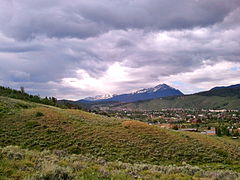
The Tenmile Range is a mountain range in U.S. state of Colorado. The range is an extension of the Mosquito Range which is part of the Rocky Mountains. The two ranges are effectively the same range. They are split only by the Continental Divide and name. The Tenmile Range is on the north side of the divide, and the Mosquito on the south. The range is often referred to as the Tenmile-Mosquito Range.
There are more than a dozen peaks in the range. Peak 1 is the northernmost peak. The sub-peaks of Mt. Victoria and Mt. Royal are located north of Peak 1. Tenmile Peak, south of Peak 1, is also known as Peak 2. Quandary Peak is the southernmost peak and highest point in the Range, elevation 14,271 feet.[2][3]
The range is famous for its skiing, both backcountry and resort areas. Breckenridge Ski Resort is in the range.
The Tenmile Range includes Pacific Tarn, believed to be the highest named lake in the United States.
Approximately 25,000 acres (100 km2) of the Tenmile Range is protected in the Camp Hale – Continental Divide National Monument.[4]
Highest peaks
- Quandary Peak 14,271
- Fletcher Mountain 13,951
- Pacific Peak
- Unnamed Peak (commonly known as "Drift Peak"[1]) 13,900
- Crystal Peak 13,852
- Atlantic Peak 13,841
- Wheeler Mountain 13,690
- Peak 10 13,633
- Father Dyer Peak 13,615, named for the clergyman John Lewis Dyer
- North Star Mountain 13,614
Additional information
- Peak 1 is the northernmost peak of the range.
- The numbered peaks begin with Peak 1 which is directly north of Tenmile Peak. This peak used to have a ski jumping hill for the town of Frisco. South of Peak 1 are Peaks 2 through 10. There are more than a dozen peaks in the range. The southernmost is Quandary Peak.[3] Wheeler Peak and North Star Mountain sit in both the Ten Mile (north) and Mosquito Ranges (south), straddling the Continental Divide.
- Breckenridge Ski Resort occupies the east faces of Peaks 6-10. The summits of Peak 6 and Peak 8 are both accessible by chairlift. The Kensho SuperChair on Peak 6 terminates at a crest in a ridge 300 feet below the summit, while the Imperial Express SuperChair stops at 12,840 feet, 160 feet below the summit of Peak 8. The true summits of both peaks can then be accessed by a short hike from the top of either lift.
-
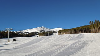
 Peak 1 seen from Silverthorne
 -
 The eastern side of Peaks 7 and 8 as viewed from the bottom of the Independence SuperChair
 -
 The Kensho SuperChair provides lift access to the summit of Peak 6
 -
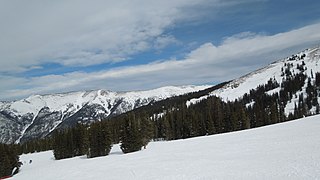 A view of Peak 4, Peak 5, and Peak 6 from near the top of the Timberline Express at Copper Mountain
 -
 A view of Peak 5 from the top of the Kensho SuperChair on Peak 6


Gallery

 Colorado portal
 Mountains portal


References
- ^ a b "13er Drift Peak | 13ers | 13er".
- ^ Ormes, Robert (1992). Guide to the Colorado Mountains. Boulder, CO: The Colorado Mountain Club. pp. 116–118. ISBN 1-55566-194-7.
- ^ a b DeLorme (1998). Colorado Atlas & Gazetteer. Yarmouth, ME: DeLorme. pp. 38, 48. ISBN 0-89933-265-X.
- ^ "President Biden Designates Camp Hale-Continental Divide National Monument". www.usda.gov. Retrieved 2022-10-12.
External links
- Tenmile Range @ Peakbagger
- v
- t
- e

- Mount Garfield
- Aspen Mountain
- Capitol Peak
- Castle Peak
- Cathedral Peak
- Chair Mountain
- Crested Butte
- Gothic Mountain
- Italian Mountain
- Maroon Bells
- Mount Emmons
- Mount Owen
- Mount Sopris
- Pyramid Peak
- Snowmass Mountain
- Snowmass Peak
- Treasure Mountain
- Black Mountain (Moffat County)
- Columbus Mountain
- Elk Mountain (Routt County)
- Hahns Peak
- Flat Top Mountain
- Sleepy Cat Peak
- Eagles Nest
- Jacque Peak
- Meridian Peak
- Mount Powell
- The Spider
- Crater Peak
- North Mamm Peak
- Clark Peak
- Arkansas Hills
- Clinton Peak
- Dyer Mountain
- Gemini Peak
- Horseshoe Mountain
- Mount Arkansas
- Mount Bross
- Mount Buckskin
- Mount Democrat
- Mount Lincoln
- Mount Sheridan
- Mount Sherman
- Pacific Peak
- West Buffalo Peak
- Elk Mountain (Grand County)
- Parkview Mountain
- Radial Mountain
- Whiteley Peak
| Sangre de Cristo Range |
|
|---|---|
| Wet Mountains |
|
| Others |
|
| Collegiate Peaks |
|
|---|---|
| Others |
|
- Crystal Peak
- Fletcher Mountain
- Peak 10
- Peak One
- Quandary Peak
- Tenmile Peak
- Bear Mountain
- Blair Mountain
- Chalk Mountains
- Cochetopa Hills
- Dawson Butte
- Diamond Peak
- Flirtation Peak
- Granite Peak
- Grand Hogback
- Grannys Nipple
- Horsefly Peak
- Lead Mountain (Grand County)
- Mount Neva
- Powell Peak
- San Luis Hills
- Storm King Mountain
- Terrible Mountain
- Two Buttes
- Ute Mountain


