Square Top Mountain
Mountain in the state of Colorado


Square Top Mountain
Location in Colorado
Show map of Colorado
Square Top Mountain
Square Top Mountain (the United States)
Show map of the United StatesFront Range
Square Top Mountain is a 13,794-foot (4,204 m) mountain summit in Clear Creek County, Colorado, United States.
Description
Square Top Mountain is set approximately one mile (1.6 km) east of the Continental Divide in the Front Range which is a subrange of the Rocky Mountains.[2] The mountain is located 42 miles (68 km) west-southwest of Denver and three miles (4.8 km) west of Guanella Pass on land managed by Arapaho National Forest and Pike National Forest. It ranks as the 111th-highest peak in Colorado.[3] Precipitation runoff from the mountain's north slope drains into South Clear Creek and the south slope drains to Geneva Creek. Topographic relief is significant as the summit rises 3,700 feet (1,128 m) above Geneva Creek in two miles (3.2 km) and 2,600 feet (792 m) above Smelter Gulch in one mile (1.6 km). An ascent of the peak involves hiking seven miles (11 km) with 2,400 feet (732 m) of elevation gain from Guanella Pass via the Square Top Lakes Trail.[1][5] The mountain's descriptive toponym was officially adopted on June 7, 1933, by the United States Board on Geographic Names.[4] Prior to that it was also called Lewis Mountain or Mt. Lewis.[4]
Climate
According to the Köppen climate classification system, Square Top is located in an alpine subarctic climate zone with cold, snowy winters, and cool to warm summers.[6] Due to its altitude, it receives precipitation all year, as snow in winter, and as thunderstorms in summer, with a dry period in late spring.
| Climate data for Square Top Mountain 39.5947 N, 105.7587 W, Elevation: 13,409 ft (4,087 m) (1991–2020 normals) | |||||||||||||
|---|---|---|---|---|---|---|---|---|---|---|---|---|---|
| Month | Jan | Feb | Mar | Apr | May | Jun | Jul | Aug | Sep | Oct | Nov | Dec | Year |
| Mean daily maximum °F (°C) | 19.6 (−6.9) | 18.6 (−7.4) | 25.3 (−3.7) | 32.6 (0.3) | 40.9 (4.9) | 51.5 (10.8) | 57.6 (14.2) | 55.0 (12.8) | 48.8 (9.3) | 37.7 (3.2) | 26.5 (−3.1) | 19.9 (−6.7) | 36.2 (2.3) |
| Daily mean °F (°C) | 9.4 (−12.6) | 8.5 (−13.1) | 14.2 (−9.9) | 20.2 (−6.6) | 28.9 (−1.7) | 38.9 (3.8) | 45.2 (7.3) | 43.3 (6.3) | 37.0 (2.8) | 26.6 (−3.0) | 16.6 (−8.6) | 9.9 (−12.3) | 24.9 (−4.0) |
| Mean daily minimum °F (°C) | −0.8 (−18.2) | −1.6 (−18.7) | 3.0 (−16.1) | 7.7 (−13.5) | 16.8 (−8.4) | 26.4 (−3.1) | 32.8 (0.4) | 31.5 (−0.3) | 25.2 (−3.8) | 15.6 (−9.1) | 6.7 (−14.1) | −0.2 (−17.9) | 13.6 (−10.2) |
| Average precipitation inches (mm) | 2.86 (73) | 2.88 (73) | 3.09 (78) | 3.56 (90) | 2.92 (74) | 1.65 (42) | 2.76 (70) | 2.61 (66) | 1.93 (49) | 2.09 (53) | 2.47 (63) | 2.67 (68) | 31.49 (799) |
| Source: PRISM Climate Group[7] | |||||||||||||
Gallery
-
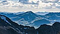
 East aspect of Square Top from Mount Bierstadt
 -
 East aspect
 -
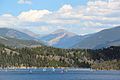 Square Top viewed from Dillon Reservoir
 -
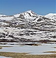
 Square Top from Mt. Evans


See also
 Mountains portal
- List of mountain peaks of Colorado

References
- ^ a b Mike Garratt, Bob Martin (1984), Colorado's High Thirteeners, Johnson Books, ISBN 9780917895395, p. 7.
- ^ a b c d "Square Top Mountain, Colorado". Peakbagger.com. Retrieved April 11, 2023.
- ^ a b c "Square Top Mountain - 13,799' CO". listsofjohn.com. Retrieved April 11, 2023.
- ^ a b c "Square Top Mountain". Geographic Names Information System. United States Geological Survey, United States Department of the Interior. Retrieved April 11, 2023.
- ^ Jon Kedrowski (2022), Classic Colorado Hikes, Colorado Mountain Club, ISBN 9781937052836
- ^ Peel, M. C.; Finlayson, B. L.; McMahon, T. A. (2007). "Updated world map of the Köppen−Geiger climate classification". Hydrol. Earth Syst. Sci. 11. ISSN 1027-5606.
- ^ "PRISM Climate Group, Oregon State University". PRISM Climate Group, Oregon State University. Retrieved October 10, 2023.
To find the table data on the PRISM website, start by clicking Coordinates (under Location); copy Latitude and Longitude figures from top of table; click Zoom to location; click Precipitation, Minimum temp, Mean temp, Maximum temp; click 30-year normals, 1991-2020; click 800m; click Retrieve Time Series button.
External links
Wikimedia Commons has media related to Square Top Mountain (Clear Creek County, Colorado).


