Navajo Peak
Mountain in the state of Colorado


Navajo Peak
Location in Colorado
Show map of Colorado
Navajo Peak
Navajo Peak (the United States)
Show map of the United StatesFront Range[6]
Navajo Peak is a 13,409-foot (4,087 m) mountain summit on the boundary shared by Boulder County and Grand County, in Colorado, United States.[4]
Description
Navajo Peak is set on the Continental Divide in the Front Range which is a subrange of the Rocky Mountains.[6] The mountain is located 21 miles (34 km) west of Boulder in the Indian Peaks Wilderness, on land managed by Arapaho National Forest and Roosevelt National Forest. It is the third-highest summit in the wilderness and fourth-highest in Grand County.[3] Precipitation runoff from the mountain's northeast slope drains into headwaters of South St. Vrain Creek, the southeast slope drains into headwaters of North Boulder Creek, and the west slope drains to Monarch Lake via Arapaho Creek. Topographic relief is significant as the summit rises 2,800 feet (853 m) above Wheeler Basin in one mile (1.6 km). An ascent of the peak involves hiking 8.9 miles (14.3 km) (round trip) with 2,825 feet (861 m) of elevation gain, with a 35-foot scramble on the summit block.[7]
History
The mountain was named by Ellsworth Bethel and the toponym was officially adopted in 1914 by the United States Board on Geographic Names. [4]
A party of five including Arnold Emch and his two sons climbed to the summit in August 1915.[8]
On January 21, 1948, an airplane en route from Denver to Grand Junction crashed at 12,900-foot-elevation on the peak, and the wreckage still remains scattered on the slopes.[7] The crash of the DC-3 was caused by a downdraft in an area of severe turbulence and resulted in the deaths of all three crewmembers.[9] The plane belonged to the Civil Aeronautics Administration and the three men were all employees: Fred Snavely (pilot), Warren Lungstrum (co-pilot), and Ross Brown.[10] The accident site was not found until four months later.
Climate
According to the Köppen climate classification system, the mountain is located in an alpine subarctic climate zone with cold, snowy winters, and cool to warm summers.[11] Due to its altitude, it receives precipitation all year, as snow in winter and as thunderstorms in summer, with a dry period in late spring. This climate supports the Arikaree Glacier on the southeast slope of the peak.
Climbing
Established climbing routes on Navajo Peak:[2]
- Airplane Gully – class 3
- West Chimney – class 4
- North Face – class 5.0–5.2
Gallery
-
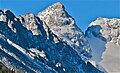
 West aspect of Navajo Peak centered.
Apache Peak (left), Arikaree Peak (right). -
 East aspect
 -
 East aspect of Navajo Peak (left, pyramid shape), Apache Peak (center), and Shoshoni Peak (right). Lake Isabelle to left.


See also
- Thirteener
 Mountains portal

References
- ^ Robert M. Ormes (1992), Guide to the Colorado Mountains, Johnson Books, ISBN 9781555661946, p. 64.
- ^ a b Gerry Roach (1998), Colorado's Indian Peaks, Fulcrum Publishing, ISBN 9781555914042, p. 174.
- ^ a b c d e "Navajo Peak- 13,419' CO". listsofjohn.com. Retrieved April 28, 2023.
- ^ a b c "Navajo Peak". Geographic Names Information System. United States Geological Survey, United States Department of the Interior. Retrieved April 28, 2023.
- ^ Jim Flynn (2016), A Compendium of Curious Colorado Place Names, Arcadia Publishing Incorporated, ISBN 9781439658734
- ^ a b "Navajo Peak, Colorado". Peakbagger.com. Retrieved April 28, 2023.
- ^ a b James Dziezynski (2012), Best Summit Hikes in Colorado, AdventureKEEN, ISBN 9780899977126, p. 61.
- ^ Roger Wolcott Toll (1919), Mountaineering in the Rocky Mountain National Park, US Government Printing Office, p. 85.
- ^ Douglas C-47-DL (DC-3) Aviation-safety.net
- ^ Accident Investigation Report (1948), Civil Aeronautics Board
- ^ Peel, M. C.; Finlayson, B. L.; McMahon, T. A. (2007). "Updated world map of the Köppen−Geiger climate classification". Hydrol. Earth Syst. Sci. 11. ISSN 1027-5606.
External links
- Navajo Peak: weather forecast
- Navajo Peak climbing: Mountainproject.com
| ||||||||||||||||


- v
- t
- e

- Mount Garfield
- Aspen Mountain
- Capitol Peak
- Castle Peak
- Cathedral Peak
- Chair Mountain
- Crested Butte
- Gothic Mountain
- Italian Mountain
- Maroon Bells
- Mount Emmons
- Mount Owen
- Mount Sopris
- Pyramid Peak
- Snowmass Mountain
- Snowmass Peak
- Treasure Mountain
- Black Mountain (Moffat County)
- Columbus Mountain
- Elk Mountain (Routt County)
- Hahns Peak
- Flat Top Mountain
- Sleepy Cat Peak
- Eagles Nest
- Jacque Peak
- Meridian Peak
- Mount Powell
- The Spider
- Crater Peak
- North Mamm Peak
- Clark Peak
- Arkansas Hills
- Clinton Peak
- Dyer Mountain
- Gemini Peak
- Horseshoe Mountain
- Mount Arkansas
- Mount Bross
- Mount Buckskin
- Mount Democrat
- Mount Lincoln
- Mount Sheridan
- Mount Sherman
- Pacific Peak
- West Buffalo Peak
- Elk Mountain (Grand County)
- Parkview Mountain
- Radial Mountain
- Whiteley Peak
| Sangre de Cristo Range |
|
|---|---|
| Wet Mountains |
|
| Others |
|
| Collegiate Peaks |
|
|---|---|
| Others |
|
- Crystal Peak
- Fletcher Mountain
- Peak 10
- Peak One
- Quandary Peak
- Tenmile Peak
- Bear Mountain
- Blair Mountain
- Chalk Mountains
- Cochetopa Hills
- Dawson Butte
- Diamond Peak
- Flirtation Peak
- Granite Peak
- Grand Hogback
- Grannys Nipple
- Horsefly Peak
- Lead Mountain (Grand County)
- Mount Neva
- Powell Peak
- San Luis Hills
- Storm King Mountain
- Terrible Mountain
- Two Buttes
- Ute Mountain


