National Register of Historic Places listings in Laurens County, South Carolina

This is a list of the National Register of Historic Places listings in Laurens County, South Carolina.
This is intended to be a complete list of the properties and districts on the National Register of Historic Places in Laurens County, South Carolina, United States. The locations of National Register properties and districts for which the latitude and longitude coordinates are included below, may be seen in a map.[1]
There are 25 properties and districts listed on the National Register in the county.
This National Park Service list is complete through NPS recent listings posted May 10, 2024.[2]
Map all coordinates using OpenStreetMap
Download coordinates as:
- KML
- GPX (all coordinates)
- GPX (primary coordinates)
- GPX (secondary coordinates)
Current listings
| [3] | Name on the Register[4] | Image | Date listed[5] | Location | City or town | Description |
|---|---|---|---|---|---|---|
| 1 | Albright-Dukes House | 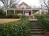 | November 19, 1986 (#86003149) | 127 Academy St. 34°29′25″N 82°01′05″W / 34.490278°N 82.018056°W / 34.490278; -82.018056 (Albright-Dukes House) | Laurens | |
| 2 | Charlton Hall Plantation House |  | May 26, 1995 (#95000633) | South Carolina Highway 101, approximately 2.5 miles south of Hickory Tavern 34°29′40″N 82°10′06″W / 34.494444°N 82.168333°W / 34.494444; -82.168333 (Charlton Hall Plantation House) | Hickory Tavern | |
| 3 | Clinton Commercial Historic District | 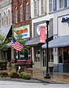 | November 15, 1984 (#84000577) | Main, Broad, Pitts, Musgrove and Gary Sts.; also 209-225 West Main St. 34°28′23″N 81°52′52″W / 34.473056°N 81.881111°W / 34.473056; -81.881111 (Clinton Commercial Historic District) | Clinton | Boundary adjustments were approved March 16, 2020 |
| 4 | Lyde Irby Darlington House | 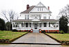 | November 19, 1986 (#86003150) | 110 Irby Ave. 34°29′41″N 82°01′05″W / 34.494722°N 82.018056°W / 34.494722; -82.018056 (Lyde Irby Darlington House) | Laurens | |
| 5 | Allen Dial House |  | January 21, 1982 (#82003874) | South Carolina Highway 729 34°28′36″N 82°06′05″W / 34.476667°N 82.101389°W / 34.476667; -82.101389 (Allen Dial House) | Laurens | |
| 6 | Charles H. Duckett House |  | November 19, 1986 (#86003151) | 105 Downs St. 34°29′46″N 82°01′42″W / 34.496111°N 82.028333°W / 34.496111; -82.028333 (Charles H. Duckett House) | Laurens | |
| 7 | Duncan's Creek Presbyterian Church |  | November 15, 1973 (#73001714) | 5 miles northeast of Clinton, off South Carolina Highway 72 34°31′18″N 81°48′29″W / 34.521667°N 81.808056°W / 34.521667; -81.808056 (Duncan's Creek Presbyterian Church) | Clinton | |
| 8 | James Dunklin House | 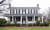 | October 1, 1974 (#74001861) | 544 W. Main St. 34°29′52″N 82°01′24″W / 34.497778°N 82.023333°W / 34.497778; -82.023333 (James Dunklin House) | Laurens | |
| 9 | Gray Court-Owings School |  | April 21, 2004 (#04000354) | 9210 South Carolina Highway 14 34°37′11″N 82°07′23″W / 34.619722°N 82.123056°W / 34.619722; -82.123056 (Gray Court-Owings School) | Gray Court | |
| 10 | Dr. William Claudius Irby House | 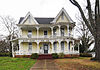 | November 19, 1986 (#86003152) | 132 Irby Ave. 34°29′38″N 82°01′06″W / 34.493889°N 82.018333°W / 34.493889; -82.018333 (Dr. William Claudius Irby House) | Laurens | |
| 11 | Irby-Henderson-Todd House | 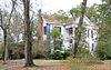 | September 8, 1983 (#83002200) | 112 Todd Ave. 34°29′28″N 82°01′52″W / 34.491111°N 82.031111°W / 34.491111; -82.031111 (Irby-Henderson-Todd House) | Laurens | |
| 12 | Laurens County Courthouse | 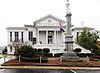 | June 19, 1972 (#72001214) | Laurens Courthouse Sq. 34°29′44″N 82°01′00″W / 34.495556°N 82.016667°W / 34.495556; -82.016667 (Laurens County Courthouse) | Laurens | |
| 13 | Laurens Historic District |  | October 10, 1980 (#80003675) | U.S. Routes 76 and 221; also both sides of W. Main St. from 742 to 964 W. Main St. 34°29′51″N 82°01′12″W / 34.4975°N 82.02°W / 34.4975; -82.02 (Laurens Historic District) | Laurens | Second set of boundaries represents a boundary increase of November 19, 1986 |
| 14 | Lindley's Fort Site | Upload image | November 7, 1978 (#78002521) | Address Restricted | Madens | |
| 15 | Nickels-Milam House | 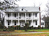 | May 28, 1976 (#76001705) | South of Laurens off U.S. Route 221 34°25′35″N 82°00′18″W / 34.426389°N 82.005°W / 34.426389; -82.005 (Nickels-Milam House) | Laurens | |
| 16 | Octagon House | 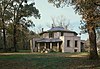 | March 20, 1973 (#73001715) | 619 E. Main St. 34°29′57″N 82°00′05″W / 34.499167°N 82.001389°W / 34.499167; -82.001389 (Octagon House) | Laurens | |
| 17 | John Calvin Owings House |  | February 23, 1978 (#78002520) | 787 W. Main St. 34°29′38″N 82°01′43″W / 34.493889°N 82.028611°W / 34.493889; -82.028611 (John Calvin Owings House) | Laurens | Designed by architect George Franklin Barber |
| 18 | Rosemont Plantation | Upload image | June 11, 1993 (#93000459) | Address Restricted | Waterloo | |
| 19 | William Dunlap Simpson House | 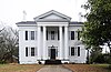 | July 24, 1974 (#74001862) | 726 W. Main St. 34°29′44″N 82°01′30″W / 34.495556°N 82.025°W / 34.495556; -82.025 (William Dunlap Simpson House) | Laurens | |
| 20 | Sitgreaves House |  | November 19, 1986 (#86003158) | 428 W. Farley Ave. 34°29′23″N 82°01′42″W / 34.489722°N 82.028333°W / 34.489722; -82.028333 (Sitgreaves House) | Laurens | |
| 21 | South Harper Historic District |  | November 19, 1986 (#86003161) | Both sides of S. Harper St. from 320 to 1037 34°29′31″N 82°00′59″W / 34.491944°N 82.016389°W / 34.491944; -82.016389 (South Harper Historic District) | Laurens | |
| 22 | Sullivan House | 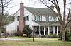 | May 22, 1973 (#73001716) | 10 miles west of Laurens on U.S. Route 76 34°30′13″N 82°13′17″W / 34.503611°N 82.221389°W / 34.503611; -82.221389 (Sullivan House) | Laurens | |
| 23 | Thornwell-Presbyterian College Historic District | 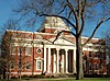 | March 5, 1982 (#82003873) | Presbyterian College Campus 34°27′58″N 81°52′48″W / 34.466111°N 81.88°W / 34.466111; -81.88 (Thornwell-Presbyterian College Historic District) | Clinton | |
| 24 | Williams-Ball-Copeland House | 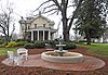 | November 19, 1986 (#86003159) | 544 Ball Dr. 34°30′01″N 82°01′30″W / 34.500278°N 82.025°W / 34.500278; -82.025 (Williams-Ball-Copeland House) | Laurens | |
| 25 | Wilson-Clary House | 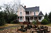 | December 11, 1986 (#86003471) | 120 Irby Ave. 34°29′40″N 82°01′06″W / 34.494444°N 82.018333°W / 34.494444; -82.018333 (Wilson-Clary House) | Laurens |
See also
Wikimedia Commons has media related to National Register of Historic Places in Laurens County, South Carolina.
- List of National Historic Landmarks in South Carolina
- National Register of Historic Places listings in South Carolina
References
- ^ The latitude and longitude information provided in this table was derived originally from the National Register Information System, which has been found to be fairly accurate for about 99% of listings. Some locations in this table may have been corrected to current GPS standards.
- ^ National Park Service, United States Department of the Interior, "National Register of Historic Places: Weekly List Actions", retrieved May 10, 2024.
- ^ Numbers represent an alphabetical ordering by significant words. Various colorings, defined here, differentiate National Historic Landmarks and historic districts from other NRHP buildings, structures, sites or objects.
- ^ "National Register Information System". National Register of Historic Places. National Park Service. March 13, 2009.
- ^ The eight-digit number below each date is the number assigned to each location in the National Register Information System database, which can be viewed by clicking the number.
- v
- t
- e

by county
- Abbeville
- Aiken
- Allendale
- Anderson
- Bamberg
- Barnwell
- Beaufort
- Berkeley
- Calhoun
- Charleston
- Cherokee
- Chester
- Chesterfield
- Clarendon
- Colleton
- Darlington
- Dillon
- Dorchester
- Edgefield
- Fairfield
- Florence
- Georgetown
- Greenville
- Greenwood
- Hampton
- Horry
- Jasper
- Kershaw
- Lancaster
- Laurens
- Lee
- Lexington
- Marion
- Marlboro
- McCormick
- Newberry
- Oconee
- Orangeburg
- Pickens
- Richland
- Saluda
- Spartanburg
- Sumter
- Union
- Williamsburg
- York
Municipalities and communities of Laurens County, South Carolina, United States | ||
|---|---|---|
County seat: Laurens | ||
| Cities | 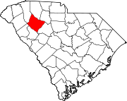 | |
| Towns | ||
| CDPs | ||
| Unincorporated communities | ||
| Footnotes | ‡This populated place also has portions in an adjacent county or counties | |
| ||


