National Register of Historic Places listings in Dorchester County, South Carolina

This is a list of the National Register of Historic Places listings in Dorchester County, South Carolina.
This is intended to be a complete list of the properties and districts on the National Register of Historic Places in Dorchester County, South Carolina, United States. The locations of National Register properties and districts for which the latitude and longitude coordinates are included below, may be seen in a map.[1]
There are 13 properties and districts listed on the National Register in the county, including 1 National Historic Landmark.
This National Park Service list is complete through NPS recent listings posted May 10, 2024.[2]
Map all coordinates using OpenStreetMap
Download coordinates as:
- KML
- GPX (all coordinates)
- GPX (primary coordinates)
- GPX (secondary coordinates)
Current listings
| [3] | Name on the Register[4] | Image | Date listed[5] | Location | City or town | Description |
|---|---|---|---|---|---|---|
| 1 | Appleby's Methodist Church |  | February 14, 1978 (#78002505) | Southwest of St. George at the junction of State Highways 19 and 71 33°08′14″N 80°39′03″W / 33.137222°N 80.650833°W / 33.137222; -80.650833 (Appleby's Methodist Church) | St. George | |
| 2 | Ashley River Historic District |  | September 12, 1994 (#93001514) | Roughly along the Ashley River from just east of South Carolina Highway 165 to the Seaboard Coast Line railroad bridge 32°54′45″N 80°07′22″W / 32.9125°N 80.122778°W / 32.9125; -80.122778 (Ashley River Historic District) | Charleston | Extends into Charleston County |
| 3 | Ashley River Road | 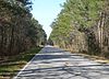 | November 21, 1983 (#83003831) | South Carolina Highway 61 between Church Creek and South Carolina Highway 165 32°53′23″N 80°07′15″W / 32.889722°N 80.120833°W / 32.889722; -80.120833 (Ashley River Road) | Cooke Crossroads | Extends into Charleston County |
| 4 | Carroll Place | 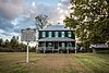 | July 25, 1974 (#74001849) | Junction of Quaker and Wire Rds. 33°07′39″N 80°38′08″W / 33.1275°N 80.635556°W / 33.1275; -80.635556 (Carroll Place) | St. George | |
| 5 | Cypress Methodist Camp Ground |  | April 26, 1978 (#78002504) | East of Ridgeville on South Carolina Highway 182 33°06′18″N 80°10′27″W / 33.105°N 80.174167°W / 33.105; -80.174167 (Cypress Methodist Camp Ground) | Ridgeville | |
| 6 | Indian Fields Methodist Campground |  | March 30, 1973 (#73001707) | About 4 miles northeast of St. George on South Carolina Highway 73 33°13′22″N 80°32′46″W / 33.222778°N 80.546111°W / 33.222778; -80.546111 (Indian Fields Methodist Campground) | St. George | |
| 7 | Middleton Place |  | May 6, 1971 (#71000770) | Southeast of Summerville on U.S. Route 61 32°54′19″N 80°08′15″W / 32.905278°N 80.1375°W / 32.905278; -80.1375 (Middleton Place) | Summerville | Remnants of an 18th-century rice plantation on the Ashley River; now a museum |
| 8 | Newington Plantation | Upload image | September 17, 1974 (#74001850) | Address Restricted | Stallsville | |
| 9 | Old Dorchester |  | December 3, 1969 (#69000165) | 6 miles south of Summerville on South Carolina Highway 642 32°57′01″N 80°10′13″W / 32.950278°N 80.170278°W / 32.950278; -80.170278 (Old Dorchester) | Summerville | |
| 10 | Old White Meeting House Ruins and Cemetery |  | February 8, 2005 (#97000445) | South Carolina Highway 642, approximately 0.5 miles southeast of its junction with South Carolina Highway 165 32°57′56″N 80°11′41″W / 32.965556°N 80.194722°W / 32.965556; -80.194722 (Old White Meeting House Ruins and Cemetery) | Summerville | |
| 11 | St. George Rosenwald School | 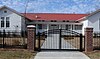 | October 2, 2018 (#100003000) | 205 Ann St. 33°11′13″N 80°34′57″W / 33.1869°N 80.5824°W / 33.1869; -80.5824 (St. George Rosenwald School) | St. George | |
| 12 | St. Paul Camp Ground |  | April 30, 1998 (#98000424) | 940 St. Paul Rd. 33°12′17″N 80°28′57″W / 33.204722°N 80.4825°W / 33.204722; -80.4825 (St. Paul Camp Ground) | Harleyville | |
| 13 | Summerville Historic District |  | May 19, 1976 (#76001701) | Roughly bounded by S. Railroad Ave., Magnolia and Main Sts., and the town boundary 33°00′53″N 80°10′59″W / 33.014722°N 80.183056°W / 33.014722; -80.183056 (Summerville Historic District) | Summerville |
See also
Wikimedia Commons has media related to National Register of Historic Places in Dorchester County, South Carolina.
- List of National Historic Landmarks in South Carolina
- National Register of Historic Places listings in South Carolina
References
- ^ The latitude and longitude information provided in this table was derived originally from the National Register Information System, which has been found to be fairly accurate for about 99% of listings. Some locations in this table may have been corrected to current GPS standards.
- ^ National Park Service, United States Department of the Interior, "National Register of Historic Places: Weekly List Actions", retrieved May 10, 2024.
- ^ Numbers represent an alphabetical ordering by significant words. Various colorings, defined here, differentiate National Historic Landmarks and historic districts from other NRHP buildings, structures, sites or objects.
- ^ "National Register Information System". National Register of Historic Places. National Park Service. March 13, 2009.
- ^ The eight-digit number below each date is the number assigned to each location in the National Register Information System database, which can be viewed by clicking the number.
- v
- t
- e

by county
- Abbeville
- Aiken
- Allendale
- Anderson
- Bamberg
- Barnwell
- Beaufort
- Berkeley
- Calhoun
- Charleston
- Cherokee
- Chester
- Chesterfield
- Clarendon
- Colleton
- Darlington
- Dillon
- Dorchester
- Edgefield
- Fairfield
- Florence
- Georgetown
- Greenville
- Greenwood
- Hampton
- Horry
- Jasper
- Kershaw
- Lancaster
- Laurens
- Lee
- Lexington
- Marion
- Marlboro
- McCormick
- Newberry
- Oconee
- Orangeburg
- Pickens
- Richland
- Saluda
- Spartanburg
- Sumter
- Union
- Williamsburg
- York
Municipalities and communities of Dorchester County, South Carolina, United States | ||
|---|---|---|
County seat: St. George | ||
| City |  | |
| Towns | ||
| CDP | ||
| Ghost town | ||
| Footnotes | ‡This populated place also has portions in an adjacent county or counties | |
| ||


