National Register of Historic Places listings in Abbeville County, South Carolina

This is a list of the National Register of Historic Places listings in Abbeville County, South Carolina.
This is intended to be a complete list of the properties and districts on the National Register of Historic Places in Abbeville County, South Carolina. The locations of National Register properties and districts for which the latitude and longitude coordinates are included below, may be seen in a map.[1]
There are 14 properties and districts listed on the National Register in the county, including 1 National Historic Landmark.
This National Park Service list is complete through NPS recent listings posted May 10, 2024.[2]
Map all coordinates using OpenStreetMap
Download coordinates as:
- KML
- GPX (all coordinates)
- GPX (primary coordinates)
- GPX (secondary coordinates)
Current listings
| [3] | Name on the Register[4] | Image | Date listed[5] | Location | City or town | Description |
|---|---|---|---|---|---|---|
| 1 | Abbeville County Courthouse | 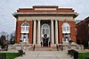 | October 30, 1981 (#81000706) | Court Square 34°10′41″N 82°22′43″W / 34.178056°N 82.378611°W / 34.178056; -82.378611 (Abbeville County Courthouse) | Abbeville | |
| 2 | Abbeville County Training School | 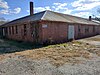 | May 27, 2022 (#100007749) | 410 Branch St. 34°10′56″N 82°22′11″W / 34.1821°N 82.3698°W / 34.1821; -82.3698 (Abbeville County Training School) | Abbeville | |
| 3 | Abbeville Historic District | | September 14, 1972 (#72001183) | Roughly bounded by the former Seaboard Coast Line tracks, South Carolina Highway 72, Rickey, Haight, Hemphill, and Haigler Sts.; also roughly east of Magazine St., south of Whitehall St., northwest along Long Branch St., west of Lemon St., and north along Washington St.; also roughly west along N. Main St. from Haigler to Livingston Sts., north along Greenville St., and northeast on Marshall Ct. 34°10′52″N 82°22′43″W / 34.181111°N 82.378611°W / 34.181111; -82.378611 (Abbeville Historic District) | Abbeville | Second and third sets of boundaries represent a boundary decrease of September 14, 1972 and a boundary increase of May 7, 1984 respectively |
| 4 | Abbeville Opera House | 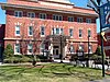 | July 1, 1970 (#70000558) | Court Square 34°10′40″N 82°22′42″W / 34.177778°N 82.378333°W / 34.177778; -82.378333 (Abbeville Opera House) | Abbeville | |
| 5 | Armistead Burt House | 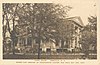 | April 3, 1970 (#70000559) | 306 N. Main St. 34°10′52″N 82°22′59″W / 34.181111°N 82.383056°W / 34.181111; -82.383056 (Armistead Burt House) | Abbeville | |
| 6 | Patrick Calhoun Family Cemetery | 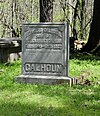 | August 28, 1975 (#75001684) | 9.5 miles southwest of Abbeville on SC 823 34°03′43″N 82°26′45″W / 34.061944°N 82.445833°W / 34.061944; -82.445833 (Patrick Calhoun Family Cemetery) | Abbeville | |
| 7 | Cedar Springs Historic District | 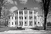 | March 25, 1982 (#82003824) | South Carolina Highways 33 and 47 34°04′50″N 82°18′08″W / 34.080556°N 82.302222°W / 34.080556; -82.302222 (Cedar Springs Historic District) | Abbeville | |
| 8 | Donalds Grange No. 497 | 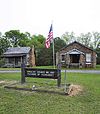 | January 9, 1995 (#94001564) | South Carolina Highway 184 34°22′06″N 82°21′07″W / 34.368333°N 82.351944°W / 34.368333; -82.351944 (Donalds Grange No. 497) | Donalds | |
| 9 | Erskine College-Due West Historic District | 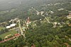 | March 19, 1982 (#82003825) | Main, Church, College, Bonner, Hayne, Washington, Cleveland, Depot, and Abbeville Sts. 34°19′45″N 82°23′26″W / 34.329167°N 82.390556°W / 34.329167; -82.390556 (Erskine College-Due West Historic District) | Due West | |
| 10 | Harbison College President's Home |  | January 13, 1983 (#83002181) | North of Abbeville on South Carolina Highway 20 34°11′45″N 82°23′05″W / 34.195833°N 82.384722°W / 34.195833; -82.384722 (Harbison College President's Home) | Abbeville | |
| 11 | Lindsay Cemetery | 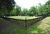 | May 27, 2009 (#09000364) | Lindsay Cemetery Rd. 34°18′01″N 82°24′58″W / 34.3003°N 82.4161°W / 34.3003; -82.4161 (Lindsay Cemetery) | Due West | |
| 12 | Trinity Episcopal Church and Cemetery | 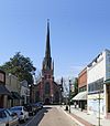 | May 6, 1971 (#71000738) | Church St. 34°10′35″N 82°22′49″W / 34.176389°N 82.380278°W / 34.176389; -82.380278 (Trinity Episcopal Church and Cemetery) | Abbeville | |
| 13 | Upper Long Cane Cemetery | 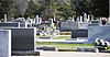 | December 17, 2010 (#10001039) | Greenville St. (South Carolina Highway 20 North) at junction with Beltline Rd. (SC Sec Rd 1-35) 34°12′13″N 82°23′24″W / 34.203611°N 82.39°W / 34.203611; -82.39 (Upper Long Cane Cemetery) | Abbeville vicinity | |
| 14 | Young Place | 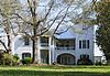 | October 9, 1974 (#74001818) | South Carolina Highway 185 34°19′59″N 82°23′56″W / 34.333056°N 82.398889°W / 34.333056; -82.398889 (Young Place) | Due West |
See also
Wikimedia Commons has media related to National Register of Historic Places in Abbeville County, South Carolina.
- List of National Historic Landmarks in South Carolina
- National Register of Historic Places listings in South Carolina
References
- ^ The latitude and longitude information provided in this table was derived originally from the National Register Information System, which has been found to be fairly accurate for about 99% of listings. Some locations in this table may have been corrected to current GPS standards.
- ^ National Park Service, United States Department of the Interior, "National Register of Historic Places: Weekly List Actions", retrieved May 10, 2024.
- ^ Numbers represent an alphabetical ordering by significant words. Various colorings, defined here, differentiate National Historic Landmarks and historic districts from other NRHP buildings, structures, sites or objects.
- ^ "National Register Information System". National Register of Historic Places. National Park Service. March 13, 2009.
- ^ The eight-digit number below each date is the number assigned to each location in the National Register Information System database, which can be viewed by clicking the number.
- v
- t
- e

by county
- Abbeville
- Aiken
- Allendale
- Anderson
- Bamberg
- Barnwell
- Beaufort
- Berkeley
- Calhoun
- Charleston
- Cherokee
- Chester
- Chesterfield
- Clarendon
- Colleton
- Darlington
- Dillon
- Dorchester
- Edgefield
- Fairfield
- Florence
- Georgetown
- Greenville
- Greenwood
- Hampton
- Horry
- Jasper
- Kershaw
- Lancaster
- Laurens
- Lee
- Lexington
- Marion
- Marlboro
- McCormick
- Newberry
- Oconee
- Orangeburg
- Pickens
- Richland
- Saluda
- Spartanburg
- Sumter
- Union
- Williamsburg
- York


