Mount Toll
Mountain in the state of Colorado


Mount Toll
Location in Colorado
Show map of Colorado
Mount Toll
Mount Toll (the United States)
Show map of the United StatesFront Range[4]
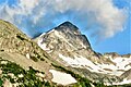
Mount Toll is a 12,979-foot (3,956 m) mountain summit on the boundary shared by Boulder County and Grand County, in Colorado, United States.[3]
Description
Mount Toll is set on the Continental Divide in the Front Range which is a subrange of the Rocky Mountains.[4] The mountain is located 21 miles (34 km) west-northwest of Boulder in the Indian Peaks Wilderness, on land managed by Arapaho National Forest and Roosevelt National Forest. It is the seventh-highest summit in the wilderness and 16th-highest in Boulder County.[2] Precipitation runoff from the mountain's east slope drains into Blue Lake thence South St. Vrain Creek, whereas the west slope drains to Monarch Lake via Cascade Creek, thence Lake Granby. Topographic relief is significant as the summit rises 2,100 feet (640 m) above Pawnee Lake in 0.6 mile (1 km) and 1,660 feet (506 m) above Blue Lake in 0.65 mile.
Etymology
The landform's toponym was officially adopted on November 19, 1940, by the United States Board on Geographic Names to honor Roger Wolcott Toll (1883–1936), American mountaineer, superintendent of nearby Rocky Mountain National Park (1921–1929), and author of The Mountain Peaks of Colorado.[3]
Climate
According to the Köppen climate classification system, the mountain is located in an alpine subarctic climate zone with cold, snowy winters, and cool to warm summers.[6] Due to its altitude, it receives precipitation all year, as snow in winter and as thunderstorms in summer, with a dry period in late spring.
Climbing
Established climbing routes on Mount Toll:[1]
- South slopes – class 2
- Southeast face – class 2
- East chimney – class 4
- Northeast ramp – class 5.0–5.2
- Northeast face – class 5.6
- North ridge – class 5.6
Gallery
-

-
-
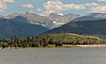 West aspect of Mt. Toll centered, viewed from Lake Granby


See also
 Mountains portal
- Mountains of Boulder County, Colorado

References
- ^ a b c Gerry Roach (1998), Colorado's Indian Peaks, Fulcrum Publishing, ISBN 9781555914042, p. 42.
- ^ a b c d "Toll, Mount - 12,989' CO". listsofjohn.com. Retrieved May 18, 2023.
- ^ a b c "Mount Toll". Geographic Names Information System. United States Geological Survey, United States Department of the Interior. Retrieved May 18, 2023.
- ^ a b "Mount Toll, Colorado". Peakbagger.com. Retrieved May 18, 2023.
- ^ a b Geologic map of the Estes Park 30' x 60' quadrangle, north-central Colorado, W.A. Braddock, U.S. Geological Survey, 1984.
- ^ Peel, M. C.; Finlayson, B. L.; McMahon, T. A. (2007). "Updated world map of the Köppen−Geiger climate classification". Hydrol. Earth Syst. Sci. 11. ISSN 1027-5606.
External links
- Mount Toll: weather forecast
- Mount Toll climbing: Mountainproject.com
Places adjacent to Mount Toll | ||||||||||||||||
|---|---|---|---|---|---|---|---|---|---|---|---|---|---|---|---|---|
| ||||||||||||||||


- v
- t
- e

- Mount Garfield
- Aspen Mountain
- Capitol Peak
- Castle Peak
- Cathedral Peak
- Chair Mountain
- Crested Butte
- Gothic Mountain
- Italian Mountain
- Maroon Bells
- Mount Emmons
- Mount Owen
- Mount Sopris
- Pyramid Peak
- Snowmass Mountain
- Snowmass Peak
- Treasure Mountain
- Black Mountain (Moffat County)
- Columbus Mountain
- Elk Mountain (Routt County)
- Hahns Peak
- Flat Top Mountain
- Sleepy Cat Peak
- Eagles Nest
- Jacque Peak
- Meridian Peak
- Mount Powell
- The Spider
- Crater Peak
- North Mamm Peak
- Clark Peak
- Arkansas Hills
- Clinton Peak
- Dyer Mountain
- Gemini Peak
- Horseshoe Mountain
- Mount Arkansas
- Mount Bross
- Mount Buckskin
- Mount Democrat
- Mount Lincoln
- Mount Sheridan
- Mount Sherman
- Pacific Peak
- West Buffalo Peak
- Elk Mountain (Grand County)
- Parkview Mountain
- Radial Mountain
- Whiteley Peak
| Sangre de Cristo Range |
|
|---|---|
| Wet Mountains |
|
| Others |
|
| Collegiate Peaks |
|
|---|---|
| Others |
|
- Crystal Peak
- Fletcher Mountain
- Peak 10
- Peak One
- Quandary Peak
- Tenmile Peak
- Bear Mountain
- Blair Mountain
- Chalk Mountains
- Cochetopa Hills
- Dawson Butte
- Diamond Peak
- Flirtation Peak
- Granite Peak
- Grand Hogback
- Grannys Nipple
- Horsefly Peak
- Lead Mountain (Grand County)
- Mount Neva
- Powell Peak
- San Luis Hills
- Storm King Mountain
- Terrible Mountain
- Two Buttes
- Ute Mountain


