Lagnieu
Commune in Auvergne-Rhône-Alpes, France
You can help expand this article with text translated from the corresponding article in French. (December 2008) Click [show] for important translation instructions.
- View a machine-translated version of the French article.
- Machine translation, like DeepL or Google Translate, is a useful starting point for translations, but translators must revise errors as necessary and confirm that the translation is accurate, rather than simply copy-pasting machine-translated text into the English Wikipedia.
- Do not translate text that appears unreliable or low-quality. If possible, verify the text with references provided in the foreign-language article.
- You must provide copyright attribution in the edit summary accompanying your translation by providing an interlanguage link to the source of your translation. A model attribution edit summary is
Content in this edit is translated from the existing French Wikipedia article at [[:fr:Lagnieu]]; see its history for attribution. - You may also add the template
{{Translated|fr|Lagnieu}}to the talk page. - For more guidance, see Wikipedia:Translation.
Commune in Auvergne-Rhône-Alpes, France

Coat of arms
Location of Lagnieu

(2020–2026) André Moingeon[1]
1
(2021)[2]
01202 /01150
(avg. 239 m or 784 ft)
Lagnieu (French pronunciation: [laɲø]; Arpitan: Lagniœ) is a commune in the Ain department in eastern France.
Geography
Lagnieu is located in the south of the department of Ain, on the right bank of the Rhone, 50 km northeast of Lyon and 37 km south of Bourg-en-Bresse. The town belongs to the canton of Lagnieu, of which it is the seat, and the arrondissement of Belley.
Attached to the foothills of southern Jura (Bugey), it belongs to the natural region of the plain of Ain, also name of the industrial park established about ten kilometers west of the town. Its territory has an altitude ranging from 192 m to 643 m, the town hall is 212 m.
History
According to a Latin text of the seventh century, Lagnieu derives from a landowner named Latinus, giving his name to the district and become Latiniacus.[3]
Around 1430, the inhabitants of Lagnieu seized six oxen belonging to the monks of the Carthusian monastery of Portes and ravaged their crops by releasing their pigs.[4]
During the French Revolution, Lagnieu took the revolutionary name of Fontaine-d'Or.[5]
In 1957, during the passage of a metal element intended for the Marcoule nuclear power plant, the "centipede", the Lagnieu fountain was accidentally destroyed.
Geology
The territory presents a seismic risk as well as natural and technological risks such as flood, dam break, industrial and nuclear risks, transport of dangerous goods. Several natural disasters have occurred in the past such as floods and mudslides (April 30 and May 1, 1983, September 26, 1987, October 9 to 12, 1988, February 13 to 18, 1990, June 25, 2006
Climate
Lagnieu, like the Lyon region, is located at a climatic crossroads. The climate is of a semi-continental type with Mediterranean aspects, especially in summer. Several southern species are present, including the Montpellier pistachio or several species of cicadas. [ref. necessary]
The absence of wind in summer contributes to the stifling summer days in the Latini area and more generally Lyon.
Population
The population data given in the table and graph below for 1962 and earlier are excluding the former commune of Proulieu, absorbed in 1965.[6]
|
| ||||||||||||||||||||||||||||||||||||||||||||||||||||||||||||||||||||||||||||||||||||||||||||||||||||||||||||||||||
| |||||||||||||||||||||||||||||||||||||||||||||||||||||||||||||||||||||||||||||||||||||||||||||||||||||||||||||||||||
| Source: EHESS[6] and INSEE[7] | |||||||||||||||||||||||||||||||||||||||||||||||||||||||||||||||||||||||||||||||||||||||||||||||||||||||||||||||||||
Politics
- 1953 1963 Eugène Jacquier Rad.
- 1963 June 1995 Guy d Verpillière (Member of Parliament (1967–80), Senator (1980–89), General Councilor of the Canton of Lagnieu (1958-1988))
- June 1995 April 2004 7 Charles d' La Verpillière President of the General Council (2004-2007)
- April 2004 - current André Moingeon UMP - LR Consulting engineer
since the 2014 council elections the makeup of the council has been 25 members for Pour Lagnieu party and 4 members for Ensemble bougeons pour Lagnieu party.
-
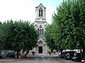 Church of Saint John the Baptist, built from 1867-1870)
 -
 Château built by Claude de Montferrand in 1471
 -
 Chapel of Plastre-de-là-Croix, cemetery


See also
References
- ^ "Répertoire national des élus: les maires". data.gouv.fr, Plateforme ouverte des données publiques françaises (in French). 2 December 2020. Archived from the original on 28 June 2020. Retrieved 24 March 2021.
- ^ "Populations légales 2021". The National Institute of Statistics and Economic Studies. 28 December 2023.
- ^ Marianne Mulon, « Anthropotoponymes. Appropriations, commémorations », in Actes du 16e Congrès international des Sciences onomastiques (16-22 août 1987), Université Laval, Québec, 1990, p.15-39.
- ^ Alain Kersuzan, Défendre la Bresse et le Bugey - Les châteaux savoyards dans la guerre contre le Dauphiné (1282 - 1355), collection Histoire et Archéologie médiévales n°14, Presses universitaires de Lyon, Lyon, 2005, (ISBN 2-7297-0762-X), p. 36.
- ^ Les noms révolutionnaires des communes de France par Figuères
- ^ a b Des villages de Cassini aux communes d'aujourd'hui: Commune data sheet Lagnieu, EHESS (in French).
- ^ Population en historique depuis 1968 Archived 24 September 2022 at the Wayback Machine, INSEE
Wikimedia Commons has media related to Lagnieu.
- v
- t
- e

- L'Abergement-Clémenciat
- L'Abergement-de-Varey
- Ambérieu-en-Bugey
- Ambérieux-en-Dombes
- Ambléon
- Ambronay
- Ambutrix
- Andert-et-Condon
- Anglefort
- Apremont
- Aranc
- Arandas
- Arbent
- Arbigny
- Arboys en Bugey
- Argis
- Armix
- Ars-sur-Formans
- Artemare
- Arvière-en-Valromey
- Asnières-sur-Saône
- Attignat
- Bâgé-Dommartin
- Bâgé-le-Châtel
- Balan
- Baneins
- Béard-Géovreissiat
- Beaupont
- Beauregard
- Béligneux
- Belleysubpr
- Belleydoux
- Bellignat
- Bénonces
- Bény
- Béréziat
- Bettant
- Bey
- Beynost
- Billiat
- Birieux
- Biziat
- Blyes
- Bohas-Meyriat-Rignat
- La Boisse
- Boissey
- Bolozon
- Bouligneux
- Bourg-en-Bressepref
- Bourg-Saint-Christophe
- Boyeux-Saint-Jérôme
- Boz
- Brégnier-Cordon
- Brénod
- Brens
- Bresse Vallons
- Bressolles
- Brion
- Briord
- Buellas
- La Burbanche
- Ceignes
- Cerdon
- Certines
- Cessy
- Ceyzériat
- Ceyzérieu
- Chalamont
- Chaleins
- Chaley
- Challes-la-Montagne
- Challex
- Champagne-en-Valromey
- Champdor-Corcelles
- Champfromier
- Chanay
- Chaneins
- Chanoz-Châtenay
- La Chapelle-du-Châtelard
- Charix
- Charnoz-sur-Ain
- Château-Gaillard
- Châtenay
- Châtillon-la-Palud
- Châtillon-sur-Chalaronne
- Chavannes-sur-Reyssouze
- Chaveyriat
- Chazey-Bons
- Chazey-sur-Ain
- Cheignieu-la-Balme
- Chevillard
- Chevroux
- Chevry
- Chézery-Forens
- Civrieux
- Cize
- Cleyzieu
- Coligny
- Collonges
- Colomieu
- Conand
- Condamine
- Condeissiat
- Confort
- Confrançon
- Contrevoz
- Conzieu
- Corbonod
- Corlier
- Cormoranche-sur-Saône
- Cormoz
- Corveissiat
- Courmangoux
- Courtes
- Crans
- Cressin-Rochefort
- Crottet
- Crozet
- Cruzilles-lès-Mépillat
- Culoz-Béon
- Curciat-Dongalon
- Curtafond
- Cuzieu
- Dagneux
- Divonne-les-Bains
- Dompierre-sur-Chalaronne
- Dompierre-sur-Veyle
- Domsure
- Dortan
- Douvres
- Drom
- Druillat
- Échallon
- Échenevex
- Évosges
- Faramans
- Fareins
- Farges
- Feillens
- Ferney-Voltaire
- Flaxieu
- Foissiat
- Francheleins
- Frans
- Garnerans
- Genouilleux
- Géovreisset
- Gexsubpr
- Giron
- Gorrevod
- Grand-Corent
- Grièges
- Grilly
- Groissiat
- Groslée-Saint-Benoît
- Guéreins
- Hautecourt-Romanèche
- Haut Valromey
- Illiat
- Injoux-Génissiat
- Innimond
- Izenave
- Izernore
- Izieu
- Jassans-Riottier
- Jasseron
- Jayat
- Journans
- Joyeux
- Jujurieux
- Labalme
- Lagnieu
- Laiz
- Lantenay
- Lapeyrouse
- Lavours
- Léaz
- Lélex
- Lent
- Lescheroux
- Leyment
- Leyssard
- Lhuis
- Lompnas
- Loyettes
- Lurcy
- Magnieu
- Maillat
- Malafretaz
- Mantenay-Montlin
- Manziat
- Marboz
- Marchamp
- Marignieu
- Marlieux
- Marsonnas
- Martignat
- Massieux
- Massignieu-de-Rives
- Matafelon-Granges
- Meillonnas
- Mérignat
- Messimy-sur-Saône
- Meximieux
- Mézériat
- Mijoux
- Mionnay
- Miribel
- Misérieux
- Mogneneins
- Montagnat
- Montagnieu
- Montanges
- Montceaux
- Montcet
- Le Montellier
- Monthieux
- Montluel
- Montmerle-sur-Saône
- Montracol
- Montréal-la-Cluse
- Montrevel-en-Bresse
- Murs-et-Gélignieux
- Nantuasubpr
- Neuville-les-Dames
- Neuville-sur-Ain
- Les Neyrolles
- Neyron
- Niévroz
- Nivigne et Suran
- Nivollet-Montgriffon
- Nurieux-Volognat
- Oncieu
- Ordonnaz
- Ornex
- Outriaz
- Oyonnax
- Ozan
- Parcieux
- Parves-et-Nattages
- Péron
- Péronnas
- Pérouges
- Perrex
- Peyriat
- Peyrieu
- Peyzieux-sur-Saône
- Pirajoux
- Pizay
- Plagne
- Le Plantay
- Plateau d'Hauteville
- Le Poizat-Lalleyriat
- Polliat
- Pollieu
- Poncin
- Pont-d'Ain
- Pont-de-Vaux
- Pont-de-Veyle
- Port
- Pougny
- Pouillat
- Prémeyzel
- Prémillieu
- Prévessin-Moëns
- Priay
- Ramasse
- Rancé
- Relevant
- Replonges
- Revonnas
- Reyrieux
- Reyssouze
- Rignieux-le-Franc
- Romans
- Rossillon
- Ruffieu
- Saint-Alban
- Saint-André-de-Bâgé
- Saint-André-de-Corcy
- Saint-André-d'Huiriat
- Saint-André-le-Bouchoux
- Saint-André-sur-Vieux-Jonc
- Saint-Bénigne
- Saint-Bernard
- Saint-Cyr-sur-Menthon
- Saint-Denis-en-Bugey
- Saint-Denis-lès-Bourg
- Saint-Didier-d'Aussiat
- Saint-Didier-de-Formans
- Saint-Didier-sur-Chalaronne
- Sainte-Croix
- Sainte-Euphémie
- Sainte-Julie
- Saint-Éloi
- Sainte-Olive
- Saint-Étienne-du-Bois
- Saint-Étienne-sur-Chalaronne
- Saint-Étienne-sur-Reyssouze
- Saint-Genis-Pouilly
- Saint-Genis-sur-Menthon
- Saint-Georges-sur-Renon
- Saint-Germain-de-Joux
- Saint-Germain-les-Paroisses
- Saint-Germain-sur-Renon
- Saint-Jean-de-Gonville
- Saint-Jean-de-Niost
- Saint-Jean-de-Thurigneux
- Saint-Jean-le-Vieux
- Saint-Jean-sur-Reyssouze
- Saint-Jean-sur-Veyle
- Saint-Julien-sur-Reyssouze
- Saint-Julien-sur-Veyle
- Saint-Just
- Saint-Laurent-sur-Saône
- Saint-Marcel
- Saint-Martin-de-Bavel
- Saint-Martin-du-Frêne
- Saint-Martin-du-Mont
- Saint-Martin-le-Châtel
- Saint-Maurice-de-Beynost
- Saint-Maurice-de-Gourdans
- Saint-Maurice-de-Rémens
- Saint-Nizier-le-Bouchoux
- Saint-Nizier-le-Désert
- Saint-Paul-de-Varax
- Saint-Rambert-en-Bugey
- Saint-Rémy
- Saint-Sorlin-en-Bugey
- Saint-Sulpice
- Saint-Trivier-de-Courtes
- Saint-Trivier-sur-Moignans
- Saint-Vulbas
- Salavre
- Samognat
- Sandrans
- Sault-Brénaz
- Sauverny
- Savigneux
- Ségny
- Seillonnaz
- Sergy
- Sermoyer
- Serrières-de-Briord
- Serrières-sur-Ain
- Servas
- Servignat
- Seyssel
- Simandre-sur-Suran
- Sonthonnax-la-Montagne
- Souclin
- Sulignat
- Surjoux-Lhopital
- Talissieu
- Tenay
- Thil
- Thoiry
- Thoissey
- Torcieu
- Tossiat
- Toussieux
- Tramoyes
- La Tranclière
- Trévoux
- Valeins
- Val-Revermont
- Valromey-sur-Séran
- Valserhône
- Vandeins
- Varambon
- Vaux-en-Bugey
- Verjon
- Vernoux
- Versailleux
- Versonnex
- Vesancy
- Vescours
- Vésines
- Vieu-d'Izenave
- Villars-les-Dombes
- Villebois
- Villemotier
- Villeneuve
- Villereversure
- Villes
- Villette-sur-Ain
- Villieu-Loyes-Mollon
- Viriat
- Virieu-le-Grand
- Virignin
- Vongnes
- Vonnas
- pref: prefecture
- subpr: subprefecture
Authority control databases | |
|---|---|
| International |
|
| National |
|


