Armix
Commune in Auvergne-Rhône-Alpes, France
Commune in Auvergne-Rhône-Alpes, France
Location of Armix

(2020–2026) Véronique Vuilloud[1]
1
(2021)[2]
01019 /01510
(avg. 720 m or 2,360 ft)
Armix is a commune in the Ain department in the Auvergne-Rhône-Alpes region of eastern France.
Geography
Armix is located some 30 km south-east of Amberieu-en-Bugey and 40 km north-west of Aix-les-Bains. It can be accessed by road D103 from Rossillon in the south passing through the village and continuing north to Premillieu. There are few small mountain roads in the commune which is entirely mountainous and mostly forested.
The Ruisseau Pointay rises near the village and flows south joining the Ruisseau de la Chana which forms part of the southern border and continues south-west to join the Furans river.[3]
Neighbouring communes and villages[3] | ||||||||||||||||
|---|---|---|---|---|---|---|---|---|---|---|---|---|---|---|---|---|
| ||||||||||||||||


Administration
This list is incomplete; you can help by adding missing items. (April 2021) |
List of mayors of Armix[4]
| From | To | Name |
|---|---|---|
| 1995 | 2001 | Georges Galley |
| 2001 | 2008 | Michel Miguet |
| 2008 | 2014 | Gérard Billon-Grand |
| 2014 | Present | Véronique Vuilloud |
Economy
The Economy of the commune of Armix is mostly Agriculture. The commune of Armix is located in the Rhone-Alpes, region in the department of Ain. The economy of the Rhone-Alpes region is based on raw materials, agriculture and energy.
Population
| Year | Pop. | ±% p.a. |
|---|---|---|
| 1968 | 48 | — |
| 1975 | 33 | −5.21% |
| 1982 | 28 | −2.32% |
| 1990 | 14 | −8.30% |
| 1999 | 15 | +0.77% |
| 2007 | 25 | +6.59% |
| 2012 | 20 | −4.36% |
| 2017 | 28 | +6.96% |
| Source: INSEE[5] | ||

Armix Photo Gallery
-
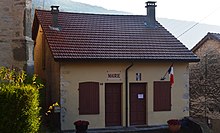
 Armix Town Square
 -
 A street in Armix
 -
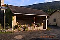 Armix Lavoir (Public Laundry)
 -
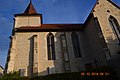 Armix Church


See also
References
- ^ "Répertoire national des élus: les maires" (in French). data.gouv.fr, Plateforme ouverte des données publiques françaises. 13 September 2022. Archived from the original on 28 June 2020. Retrieved 22 November 2022.
- ^ "Populations légales 2021". The National Institute of Statistics and Economic Studies. 28 December 2023.
- ^ a b Google Maps
- ^ List of Mayors of France Archived 9 August 2014 at the Wayback Machine (in French)
- ^ Population en historique depuis 1968 Archived 26 July 2022 at the Wayback Machine, INSEE
External links
- Armix on the old IGN website (in French)
- Armix on the 1750 Cassini Map
Wikimedia Commons has media related to Armix.
- v
- t
- e

- L'Abergement-Clémenciat
- L'Abergement-de-Varey
- Ambérieu-en-Bugey
- Ambérieux-en-Dombes
- Ambléon
- Ambronay
- Ambutrix
- Andert-et-Condon
- Anglefort
- Apremont
- Aranc
- Arandas
- Arbent
- Arbigny
- Arboys en Bugey
- Argis
- Armix
- Ars-sur-Formans
- Artemare
- Arvière-en-Valromey
- Asnières-sur-Saône
- Attignat
- Bâgé-Dommartin
- Bâgé-le-Châtel
- Balan
- Baneins
- Béard-Géovreissiat
- Beaupont
- Beauregard
- Béligneux
- Belleysubpr
- Belleydoux
- Bellignat
- Bénonces
- Bény
- Béréziat
- Bettant
- Bey
- Beynost
- Billiat
- Birieux
- Biziat
- Blyes
- Bohas-Meyriat-Rignat
- La Boisse
- Boissey
- Bolozon
- Bouligneux
- Bourg-en-Bressepref
- Bourg-Saint-Christophe
- Boyeux-Saint-Jérôme
- Boz
- Brégnier-Cordon
- Brénod
- Brens
- Bresse Vallons
- Bressolles
- Brion
- Briord
- Buellas
- La Burbanche
- Ceignes
- Cerdon
- Certines
- Cessy
- Ceyzériat
- Ceyzérieu
- Chalamont
- Chaleins
- Chaley
- Challes-la-Montagne
- Challex
- Champagne-en-Valromey
- Champdor-Corcelles
- Champfromier
- Chanay
- Chaneins
- Chanoz-Châtenay
- La Chapelle-du-Châtelard
- Charix
- Charnoz-sur-Ain
- Château-Gaillard
- Châtenay
- Châtillon-la-Palud
- Châtillon-sur-Chalaronne
- Chavannes-sur-Reyssouze
- Chaveyriat
- Chazey-Bons
- Chazey-sur-Ain
- Cheignieu-la-Balme
- Chevillard
- Chevroux
- Chevry
- Chézery-Forens
- Civrieux
- Cize
- Cleyzieu
- Coligny
- Collonges
- Colomieu
- Conand
- Condamine
- Condeissiat
- Confort
- Confrançon
- Contrevoz
- Conzieu
- Corbonod
- Corlier
- Cormoranche-sur-Saône
- Cormoz
- Corveissiat
- Courmangoux
- Courtes
- Crans
- Cressin-Rochefort
- Crottet
- Crozet
- Cruzilles-lès-Mépillat
- Culoz-Béon
- Curciat-Dongalon
- Curtafond
- Cuzieu
- Dagneux
- Divonne-les-Bains
- Dompierre-sur-Chalaronne
- Dompierre-sur-Veyle
- Domsure
- Dortan
- Douvres
- Drom
- Druillat
- Échallon
- Échenevex
- Évosges
- Faramans
- Fareins
- Farges
- Feillens
- Ferney-Voltaire
- Flaxieu
- Foissiat
- Francheleins
- Frans
- Garnerans
- Genouilleux
- Géovreisset
- Gexsubpr
- Giron
- Gorrevod
- Grand-Corent
- Grièges
- Grilly
- Groissiat
- Groslée-Saint-Benoît
- Guéreins
- Hautecourt-Romanèche
- Haut Valromey
- Illiat
- Injoux-Génissiat
- Innimond
- Izenave
- Izernore
- Izieu
- Jassans-Riottier
- Jasseron
- Jayat
- Journans
- Joyeux
- Jujurieux
- Labalme
- Lagnieu
- Laiz
- Lantenay
- Lapeyrouse
- Lavours
- Léaz
- Lélex
- Lent
- Lescheroux
- Leyment
- Leyssard
- Lhuis
- Lompnas
- Loyettes
- Lurcy
- Magnieu
- Maillat
- Malafretaz
- Mantenay-Montlin
- Manziat
- Marboz
- Marchamp
- Marignieu
- Marlieux
- Marsonnas
- Martignat
- Massieux
- Massignieu-de-Rives
- Matafelon-Granges
- Meillonnas
- Mérignat
- Messimy-sur-Saône
- Meximieux
- Mézériat
- Mijoux
- Mionnay
- Miribel
- Misérieux
- Mogneneins
- Montagnat
- Montagnieu
- Montanges
- Montceaux
- Montcet
- Le Montellier
- Monthieux
- Montluel
- Montmerle-sur-Saône
- Montracol
- Montréal-la-Cluse
- Montrevel-en-Bresse
- Murs-et-Gélignieux
- Nantuasubpr
- Neuville-les-Dames
- Neuville-sur-Ain
- Les Neyrolles
- Neyron
- Niévroz
- Nivigne et Suran
- Nivollet-Montgriffon
- Nurieux-Volognat
- Oncieu
- Ordonnaz
- Ornex
- Outriaz
- Oyonnax
- Ozan
- Parcieux
- Parves-et-Nattages
- Péron
- Péronnas
- Pérouges
- Perrex
- Peyriat
- Peyrieu
- Peyzieux-sur-Saône
- Pirajoux
- Pizay
- Plagne
- Le Plantay
- Plateau d'Hauteville
- Le Poizat-Lalleyriat
- Polliat
- Pollieu
- Poncin
- Pont-d'Ain
- Pont-de-Vaux
- Pont-de-Veyle
- Port
- Pougny
- Pouillat
- Prémeyzel
- Prémillieu
- Prévessin-Moëns
- Priay
- Ramasse
- Rancé
- Relevant
- Replonges
- Revonnas
- Reyrieux
- Reyssouze
- Rignieux-le-Franc
- Romans
- Rossillon
- Ruffieu
- Saint-Alban
- Saint-André-de-Bâgé
- Saint-André-de-Corcy
- Saint-André-d'Huiriat
- Saint-André-le-Bouchoux
- Saint-André-sur-Vieux-Jonc
- Saint-Bénigne
- Saint-Bernard
- Saint-Cyr-sur-Menthon
- Saint-Denis-en-Bugey
- Saint-Denis-lès-Bourg
- Saint-Didier-d'Aussiat
- Saint-Didier-de-Formans
- Saint-Didier-sur-Chalaronne
- Sainte-Croix
- Sainte-Euphémie
- Sainte-Julie
- Saint-Éloi
- Sainte-Olive
- Saint-Étienne-du-Bois
- Saint-Étienne-sur-Chalaronne
- Saint-Étienne-sur-Reyssouze
- Saint-Genis-Pouilly
- Saint-Genis-sur-Menthon
- Saint-Georges-sur-Renon
- Saint-Germain-de-Joux
- Saint-Germain-les-Paroisses
- Saint-Germain-sur-Renon
- Saint-Jean-de-Gonville
- Saint-Jean-de-Niost
- Saint-Jean-de-Thurigneux
- Saint-Jean-le-Vieux
- Saint-Jean-sur-Reyssouze
- Saint-Jean-sur-Veyle
- Saint-Julien-sur-Reyssouze
- Saint-Julien-sur-Veyle
- Saint-Just
- Saint-Laurent-sur-Saône
- Saint-Marcel
- Saint-Martin-de-Bavel
- Saint-Martin-du-Frêne
- Saint-Martin-du-Mont
- Saint-Martin-le-Châtel
- Saint-Maurice-de-Beynost
- Saint-Maurice-de-Gourdans
- Saint-Maurice-de-Rémens
- Saint-Nizier-le-Bouchoux
- Saint-Nizier-le-Désert
- Saint-Paul-de-Varax
- Saint-Rambert-en-Bugey
- Saint-Rémy
- Saint-Sorlin-en-Bugey
- Saint-Sulpice
- Saint-Trivier-de-Courtes
- Saint-Trivier-sur-Moignans
- Saint-Vulbas
- Salavre
- Samognat
- Sandrans
- Sault-Brénaz
- Sauverny
- Savigneux
- Ségny
- Seillonnaz
- Sergy
- Sermoyer
- Serrières-de-Briord
- Serrières-sur-Ain
- Servas
- Servignat
- Seyssel
- Simandre-sur-Suran
- Sonthonnax-la-Montagne
- Souclin
- Sulignat
- Surjoux-Lhopital
- Talissieu
- Tenay
- Thil
- Thoiry
- Thoissey
- Torcieu
- Tossiat
- Toussieux
- Tramoyes
- La Tranclière
- Trévoux
- Valeins
- Val-Revermont
- Valromey-sur-Séran
- Valserhône
- Vandeins
- Varambon
- Vaux-en-Bugey
- Verjon
- Vernoux
- Versailleux
- Versonnex
- Vesancy
- Vescours
- Vésines
- Vieu-d'Izenave
- Villars-les-Dombes
- Villebois
- Villemotier
- Villeneuve
- Villereversure
- Villes
- Villette-sur-Ain
- Villieu-Loyes-Mollon
- Viriat
- Virieu-le-Grand
- Virignin
- Vongnes
- Vonnas
- pref: prefecture
- subpr: subprefecture
Authority control databases | |
|---|---|
| International |
|
| National |
|


