Ajax Peak
Mountain summit in Colorado, US


Ajax Peak
Location in Colorado
Show map of Colorado
Ajax Peak
Ajax Peak (the United States)
Show map of the United StatesColorado, US
San Juan Mountains
Ajax Peak is a 12,785-foot-elevation (3,897-meter) mountain summit located in San Miguel County of southwest Colorado, United States.[3] It is situated on land managed by Uncompahgre National Forest, and is the iconic landmark visible three miles east of the community of Telluride. Ajax is set immediately south of Savage Basin and the ghost town of Tomboy, one mile southwest of Chicago Peak, and one mile west of Telluride Peak. It is also immediately northeast of Bridal Veil Falls, Colorado's highest waterfall at 365-feet high.[6] It is part of the San Juan Mountains which are a subset of the Rocky Mountains. Topographic relief is significant as the west aspect rises 3,800 feet (1,200 meters) above the box canyon in approximately one mile. The old mill town of Pandora at the base of Ajax Peak was hit by snow slides each winter, and one particularly bad event in 1884 came over the Ajax Mine and wrecked the mills.[7]
Climate
According to the Köppen climate classification system, Ajax Peak has an alpine subarctic climate with cold, snowy winters, and cool to warm summers.[8] Due to its altitude, it receives precipitation all year, as snow in winter, and as thunderstorms in summer, with a dry period in late spring. Precipitation runoff from the mountain drains into tributaries and headwaters of the San Miguel River.
Gallery
-
 Ajax Peak's west aspect (centered) in late winter
 -
 Ajax Peak from Telluride's Colorado Avenue
 -
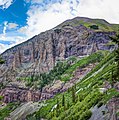 Detail of lower southwest cliffs of Ajax Peak
 -
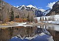
 Ajax with San Miguel River
 -
 Ajax left of center, with San Miguel River
 -


See also
 Mountains portal
 Colorado portal


- Mountains of San Miguel County, Colorado
References
- ^ a b "Ajax Peak, Colorado". Peakbagger.com.
- ^ a b "Ajax Peak - 12,785' CO". listsofjohn.com. Retrieved 2021-07-14.
- ^ a b "Ajax Peak". Geographic Names Information System. United States Geological Survey, United States Department of the Interior. Retrieved 2021-07-14.
- ^ William Bright, Colorado Place Names, 2004, Johnson Books, ISBN 9781555663339, page 3.
- ^ Don Scarmuzzi, 2005, Telluride Trails, Pruett Publishing Company, ISBN 9780871089380, page 60.
- ^ Hugh McNaughtan, Lonely Planet Western USA, 2018
- ^ Caroline Bancroft, Unique Ghost Towns and Mountain Spots, 1961, Johnson Publishing Company, ISBN 9780933472242, page 92.
- ^ Peel, M. C.; Finlayson, B. L.; McMahon, T. A. (2007). "Updated world map of the Köppen−Geiger climate classification". Hydrol. Earth Syst. Sci. 11. ISSN 1027-5606.
External links
- Ajax Peak trail: US Forest Service
- Weather forecast: Ajax Peak
- Ajax summit view: YouTube
- v
- t
- e

- Mount Garfield
- Aspen Mountain
- Capitol Peak
- Castle Peak
- Cathedral Peak
- Chair Mountain
- Crested Butte
- Gothic Mountain
- Italian Mountain
- Maroon Bells
- Mount Emmons
- Mount Owen
- Mount Sopris
- Pyramid Peak
- Snowmass Mountain
- Snowmass Peak
- Treasure Mountain
- Black Mountain (Moffat County)
- Columbus Mountain
- Elk Mountain (Routt County)
- Hahns Peak
- Flat Top Mountain
- Sleepy Cat Peak
- Eagles Nest
- Jacque Peak
- Meridian Peak
- Mount Powell
- The Spider
- Crater Peak
- North Mamm Peak
- Clark Peak
- Arkansas Hills
- Clinton Peak
- Dyer Mountain
- Gemini Peak
- Horseshoe Mountain
- Mount Arkansas
- Mount Bross
- Mount Buckskin
- Mount Democrat
- Mount Lincoln
- Mount Sheridan
- Mount Sherman
- Pacific Peak
- West Buffalo Peak
- Elk Mountain (Grand County)
- Parkview Mountain
- Radial Mountain
- Whiteley Peak
| Sangre de Cristo Range |
|
|---|---|
| Wet Mountains |
|
| Others |
|
| Collegiate Peaks |
|
|---|---|
| Others |
|
- Crystal Peak
- Fletcher Mountain
- Peak 10
- Peak One
- Quandary Peak
- Tenmile Peak
- Bear Mountain
- Blair Mountain
- Chalk Mountains
- Cochetopa Hills
- Dawson Butte
- Diamond Peak
- Flirtation Peak
- Granite Peak
- Grand Hogback
- Grannys Nipple
- Horsefly Peak
- Lead Mountain (Grand County)
- Mount Neva
- Powell Peak
- San Luis Hills
- Storm King Mountain
- Terrible Mountain
- Two Buttes
- Ute Mountain


