County Coryell, Texas
| Coryell County, Texas | |
|---|---|
 The Coryell County Courthouse in Gatesville, Texas. The courthouse was added to the National Register of Historic Places on August 18, 1977. | |
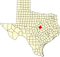 Lokasi di negara bagian Texas | |
 Lokasi negara bagian Texas di Amerika Serikat | |
| Didirikan | 1854 |
| Seat | Gatesville |
| Wilayah | |
| • Keseluruhan | 1.057 sq mi (2.738 km2) |
| • Daratan | 1.052 sq mi (2.725 km2) |
| • Perairan | 5 sq mi (13 km2), 0.47% |
| Populasi | |
| • (2000) | 74.978 |
| • Kepadatan | 73/sq mi (28/km²) |
Coryell County adalah county yang terletak di negara bagian Texas, Amerika Serikat. Jumlah penduduk pada tahun 2000 sebesar 74.978 jiwa.
Jalan utama
 U.S. Highway 84
 U.S. Highway 190
 State Highway 36


Pranala luar
- Texas State Directory, County officials
- Coryell County di Curlie (dari DMOZ)
- Coryell County in Handbook of Texas Online at the University of Texas
- Read James Coryell's entry in the Biographical Encyclopedia of Texas hosted by the Portal to Texas History.
 | Hamilton County | Bosque County | McLennan County | |
 | ||||
 | ||||
| Lampasas County | Bell County |

Templat:Coryell County, Texas
 Negara bagian Texas Negara bagian Texas | |
|---|---|
Austin (ibu kota) | |
| Topik |
|
| Region |
|
| Wilayah metro |
|
| County |
|
 | Artikel bertopik geografi atau tempat Amerika Serikat ini adalah sebuah rintisan. Anda dapat membantu Wikipedia dengan mengembangkannya. |
- l
- b
- s


