Tule Lake National Wildlife Refuge
Wildlife refuge in northern California, United States
41°56′48″N 121°33′54″W / 41.94667°N 121.56500°W / 41.94667; -121.56500
The Tule Lake National Wildlife Refuge is a National Wildlife Refuge of the United States in northern California near the Oregon border. It covers 39,116 acres (15,830 ha) in the Tule Lake basin. It is part of the Klamath Basin National Wildlife Refuge Complex, and is a crucial part of the Pacific Flyway corridor for migratory birds.[1][2]
The refuge was established in 1928 by President Calvin Coolidge to preserve habitat for birds and other animals. It is a staging area for migrating waterfowl such as the greater white-fronted goose, snow goose, Ross's goose, and cackling goose.[3] The refuge's waterways are inhabited by endangered fish species such as the Lost River sucker and shortnose sucker.[3][4]
Local habitat types include uplands vegetated with grasses and shrubs such as sagebrush, and wetlands such as marshes.[5] The refuge also includes about 19,000 acres of cropland leased to growers. Crops include potato, onion, horseradish, alfalfa, and cereals.[3]
Recreation opportunities and public services include wildlife viewing and photography, education, and hunting.[6]
Gallery
-
 Sunrise on Discovery Marsh
 -
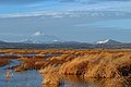 Tule Lake lower marsh
 -
 Visitors' Center
 -
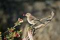 Sage thrasher on the refuge


See also
References
- ^ "Klamath water arrives, saving 50,000 ducklings from certain death". SF Chronicle. July 24, 2020. Retrieved July 25, 2020.
- ^ Schwartz, Alex (November 22, 2021). "How Tule Lake Refuge avoided another disaster". Indian Country Today. (Klamath Falls) Herald and News. Retrieved April 17, 2022.
- ^ a b c About the Tule Lake National Wildlife Refuge. USFWS.
- ^ Alexander, Kurtis (April 15, 2022). "A vast California lake is set to run dry. Scientists are scrambling to save its endangered fish". San Francisco Chronicle. Retrieved April 17, 2022.
- ^ Tule Lake National Wildlife Refuge: Habitat. USFWS.
- ^ Tule Lake National Wildlife Refuge: Visitor Activities. USFWS.
External links
 Media related to Tule Lake National Wildlife Refuge at Wikimedia Commons
- Tule Lake National Wildlife Refuge. USFWS.
- v
- t
- e
| |||||||||||||||||
National Forests and Grasslands | |||||||
|---|---|---|---|---|---|---|---|
| |||||||
|
| |||||||
| |||||||
|
|
- Heritage registers
- National Natural Landmarks
Authority control databases | |
|---|---|
| International |
|
| National |
|
 | This Modoc County, California-related article is a stub. You can help Wikipedia by expanding it. |
- v
- t
- e
 | This Siskiyou County, California-related article is a stub. You can help Wikipedia by expanding it. |
- v
- t
- e
 | This article related to a protected area in California is a stub. You can help Wikipedia by expanding it. |
- v
- t
- e


