Nature reserve in Santa Barbara County, California
34°42′N 120°1′W / 34.700°N 120.017°W / 34.700; -120.017[1]| Area | 5,896 acres (9.213 sq mi) |
|---|
| Governing body | University of California, Santa Barbara[2] |
|---|
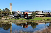
Sedgwick Reserve is a 5,896-acre (2,386 ha) nature reserve in Santa Barbara County, California, United States. It is located in the San Rafael Mountains, 35 miles north of Santa Barbara near the town of Santa Ynez.[2] The reserve is used for natural science research and education as it includes a wide range of native ecosystems, such as vernal pools, chaparral, and coastal sage scrub.
Administered by the University of California, Santa Barbara, it is a unit of the University of California Natural Reserve System.[2] The reserve hosts researchers, classes, and relevant meetings at a small complex of buildings in the field station. The reserve does not have public hiking trails, and is closed to the public except for registered and ticketed events.
The reserve hosted the Prescribed Fire Training Exchange (TREX) held November 12-19, 2022 and November 10-19, 2023 with a controlled fire by firefighters. The training on how to safely conduct prescribed burns, seminars on local fire ecology, and tribal burning included Santa Barbara County Fire Department, employees of the Santa Ynez Band of Chumash Indians, The Nature Conservancy, University of California Agriculture and Natural Resources, Vandenberg Space Force Base, scientists, ranchers, students, researchers, and land managers.[3]
See also
References
- ^ "LAT LONG NRS Reserves". Archived from the original on January 30, 2011. Retrieved January 16, 2011.
- ^ a b c Countis, Sierra (July 28, 2006). "Youth camp receives $65K grant". Sierra Sun. Swift Communications. Retrieved January 16, 2011.
- ^ Fausey, Callie (November 16, 2022). "UCSB Sedgwick Reserve Planned to Go Up in Flames on November 17". The Santa Barbara Independent. Retrieved November 18, 2022.
External links
National Park System |
|---|
| Parks | |
|---|
| Preserves | |
|---|
| Monuments | |
|---|
| Seashores | |
|---|
| Historical Parks | |
|---|
| Historic Sites | |
|---|
| Memorials | |
|---|
| Recreation Areas | |
|---|
|
|
|
|---|
| Parks | |
|---|
| Natural Reserves | |
|---|
| Marine Reserves | |
|---|
| Historic Parks | |
|---|
| Beaches | |
|---|
| Recreation Areas | |
|---|
Vehicular
Recreation Areas | |
|---|
| Other | |
|---|
|
|
National Forests and Grasslands |
|---|
National Forests
and Grasslands | |
|---|
National Wilderness
Preservation System | |
|---|
National Monuments
and Recreation Areas | |
|---|
|
|
|
|
|
|---|
Wildlife
Areas | |
|---|
Ecological
Reserves | |
|---|
Marine
Protected
Areas | |
|---|
|
|
|
|---|
| National Monuments | |
|---|
National
Conservation Areas | - California Desert
- King Range
|
|---|
| Wilderness Areas | |
|---|
|
|
|
|
|
|
|
University of California, Santa Barbara |
|---|
| Academics | | |
|---|
| Institutes | |
|---|
| Campus life | |
|---|
| Athletics | |
|---|
| People | |
|---|
 Category Category Commons Commons
|