Telluride Historic District
Historic district in Colorado, United States
United States historic place
Telluride Historic District | |
U.S. National Historic Landmark District | |
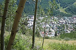 Telluride from a hiking trail above, in 2005 | |
37°56′14″N 107°48′29″W / 37.93722°N 107.80806°W / 37.93722; -107.80806 | |
| Area | 87 acres (35 ha) |
|---|---|
| Built | 1878 |
| Architect | Multiple |
| Architectural style | Late Victorian, Gothic Revival |
| NRHP reference No. | 66000256 |
| Significant dates | |
| Added to NRHP | October 15, 1966[1] |
| Designated NHLD | July 4, 1961[2] |
The Telluride Historic District encompasses a significant portion of the developed area of the former mining boom town of Telluride, Colorado. Telluride was founded in 1878, and was a major metals mining center until 1913. The historic district covers 80 acres (32 ha) of downtown Telluride and surrounding residential areas, as well as Lone Tree Cemetery, the town's first cemetery.[3] It was declared a National Historic Landmark in 1961 for its well-preserved late boom-town architecture.[2][3]
Description and history
Telluride's history begins with the discovery of silver in the area in 1875, resulting in the creation of a large mining camp, which was incorporated in 1878. The city's importance as a mining center was cemented by the construction of a wagon road in 1882 and the arrival of the railroad in 1890, facilitating the transport of the mined ores to smelters further east. The arrival of the railroad also spurred a construction boom, resulting in much of the historic architecture seen in the city today.[3]
The historic district includes most of Colorado Street, which serves as the city's main commercial avenue. The city was laid out in a manner typical of other boom towns, with higher-end housing on the slope above the main street, and lower class housing and industrial activities set below it, along with its red light district, gambling saloons, and the city jail. Distinctive surviving elements in the latter area include several bordello cribs, small wood-frame portable structures from which prostitutes plied their trade. Surviving along Colorado Street are several false front commercial buildings that survive from its early mining camp days.[3]
See also
Wikimedia Commons has media related to Telluride Historic District.
- List of National Historic Landmarks in Colorado
- National Register of Historic Places in San Miguel County, Colorado
References
- ^ "National Register Information System". National Register of Historic Places. National Park Service. April 15, 2008.
- ^ a b "Telluride Historic District". National Historic Landmark summary listing. National Park Service. Retrieved June 19, 2008.
- ^ a b c d Christine Whitacre (November 1987) National Register of Historic Places Inventory-Nomination: Telluride National Historic Landmark District, National Park Service and Accompanying photos, some from 1975
- v
- t
- e
State of Colorado
Denver (capital)
- Bibliography
- Index
- Outline
- Climate change
- Colleges
- Coloradans
- Elections
- Federal lands
- Geography
- Government
- Historic places
- History
- Images
- Indian reservations
- Law
- Lists
- Military
- Mountains
- Municipalities
- Museums
- National Forests
- National Parks
- Paleontology
- Prehistoric sites
- Prehistory
- Protected areas
- Railroads
- Rivers
- Slavery
- Statistical areas
- Symbols
- Timeline
- Tourist attractions
- Towns
- Trails
- Transportation
- Wildernesses
- Alamosa
- Arvada
- Aspen
- Aurora
- Black Hawk
- Boulder
- Brighton
- Broomfield
- Brush
- Burlington
- Cañon City
- Castle Pines
- Centennial
- Central City
- Cherry Hills Village
- Colorado Springs
- Commerce City
- Cortez
- Craig
- Cripple Creek
- Dacono
- Delta
- Denver
- Durango
- Edgewater
- Englewood
- Evans
- Federal Heights
- Florence
- Fort Collins
- Fort Lupton
- Fort Morgan
- Fountain
- Fruita
- Glendale
- Glenwood Springs
- Golden
- Grand Junction
- Greeley
- Greenwood Village
- Gunnison
- Holyoke
- Idaho Springs
- La Junta
- Lafayette
- Lakewood
- Lamar
- Las Animas
- Leadville
- Littleton
- Lone Tree
- Longmont
- Louisville
- Loveland
- Manitou Springs
- Monte Vista
- Montrose
- Northglenn
- Ouray
- Pueblo
- Rifle
- Rocky Ford
- Salida
- Sheridan
- Steamboat Springs
- Sterling
- Thornton
- Trinidad
- Victor
- Walsenburg
- Westminster
- Wheat Ridge
- Woodland Park
- Wray
- Yuma
- Adams
- Alamosa
- Arapahoe
- Archuleta
- Baca
- Bent
- Boulder
- Broomfield
- Chaffee
- Cheyenne
- Clear Creek
- Conejos
- Costilla
- Crowley
- Custer
- Delta
- Denver
- Dolores
- Douglas
- Eagle
- El Paso
- Elbert
- Fremont
- Garfield
- Gilpin
- Grand
- Gunnison
- Hinsdale
- Huerfano
- Jackson
- Jefferson
- Kiowa
- Kit Carson
- La Plata
- Lake
- Larimer
- Las Animas
- Lincoln
- Logan
- Mesa
- Mineral
- Moffat
- Montezuma
- Montrose
- Morgan
- Otero
- Ouray
- Park
- Phillips
- Pitkin
- Prowers
- Pueblo
- Rio Blanco
- Rio Grande
- Routt
- Saguache
- San Juan
- San Miguel
- Sedgwick
- Summit
- Teller
- Washington
- Weld
- Yuma
- Central Colorado
- Eastern Plains
- Colorado Mineral Belt
- Colorado Piedmont
- Colorado Plateau
- Colorado Western Slope
- Denver Metropolitan Area
- Four Corners Region
- Front Range Urban Corridor
- High Plains
- North Central Colorado Urban Area
- Northwestern Colorado
- San Luis Valley
- South-Central Colorado
- South Central Colorado Urban Area
- Southern Rocky Mountains
- Southwest Colorado
 Colorado portal
| |
|---|---|
| Topics | |
| Lists by state |
|
| Lists by insular areas | |
| Lists by associated state | |
| Other areas | |
| Related | |
| |


Authority control databases | |
|---|---|
| International |
|
| National |
|


