List of national natural landmarks in Colorado
List of National Natural Landmarks in the U.S. State of Colorado
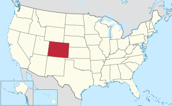
This is a list of National Natural Landmarks in the U.S. state of Colorado.
There are 16 National Natural Landmarks in Colorado, one of which extends into Wyoming. They cover areas of geological, biological and historical importance, and include lakes, mountains, rock formations and numerous fossil sites. The landmarks are located in 14 of the state's 64 counties. Four counties each contain all or part of two NNLs, while two landmarks are split between two counties. The first two designations, Slumgullion Earthflow and Summit Lake, were made in 1965, while the most recent designation, Sulphur Cave and Spring, was made in 2021.[1][2][3] Natural Landmarks in Colorado range from 60 to 380,000 acres (24.3 to 153,780.5 ha; 0.1 to 593.8 sq mi) in size. Owners include private individuals and several municipal, state and federal agencies.[4]
The National Natural Landmarks Program is administered by the National Park Service, a branch of the Department of the Interior. The National Park Service determines which properties meet NNL criteria and, after notifying the owners, makes nomination recommendations. The Secretary of the Interior reviews nominations and, based on a set of predetermined criteria, makes a decision on NNL designation or a determination of eligibility for designation. Both public and privately owned properties can be designated as NNLs. Owners may object to the nomination of the property as a NNL.[5] This designation provides indirect, partial protection of the historic integrity of the properties via tax incentives, grants, monitoring of threats, and other means.[6]
National Natural Landmarks
Map all coordinates using OpenStreetMap
Download coordinates as:
- KML
- GPX (all coordinates)
- GPX (primary coordinates)
- GPX (secondary coordinates)


Big Spring Creek
Hanging Lake
Morrison-Golden Fossil Areas
Raton Mesa
Russell Lakes
Sand Creek
Sulphur Cave and Spring
class=notpageimage|
Colorado National Natural Landmarks (clickable map)| # | Name | Image | Year | Location | County | Ownership | Description |
|---|---|---|---|---|---|---|---|
| 1 | Big Spring Creek | 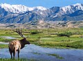 | 2012 | 37°46′00″N 105°37′30″W / 37.7666667°N 105.6250000°W / 37.7666667; -105.6250000 (Big Spring Creek) | Saguache | Federal | Unique spring-fed creek fed by an unconfined aquifer, creating a rare animal- and plant-supporting wetlands in a generally arid area. Part of Great Sand Dunes National Park and Preserve.[7] |
| 2 | Garden of the Gods | 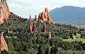 | 1971 | 38°52′04″N 104°53′28″W / 38.8677690°N 104.8910877°W / 38.8677690; -104.8910877 (Garden of the Gods) | El Paso | Municipal | The site showcases the lithologic character of sedimentary rocks, as well as providing a habitat for North American honey ants and excellent viewing opportunities for several bird species.[8] |
| 3 | Garden Park Fossil Area |  | 1973 | 38°32′06″N 105°13′18″W / 38.5349959°N 105.2216545°W / 38.5349959; -105.2216545 (Garden Park Fossil Area) | Fremont | Federal | Internationally recognized paleontological site renowned for finds of dinosaur, fish, crocodile, turtle and mammal fossils. Located on Bureau of Land Management land.[9] |
| 4 | Hanging Lake |  | 2011 | 39°36′05″N 107°11′30″W / 39.6013883°N 107.1917138°W / 39.6013883; -107.1917138 (Hanging Lake) | Garfield | Federal | Travertine deposition-formed lake with substantial hanging garden plant life and minimal human alteration, unique in the region. A part of White River National Forest.[10] |
| 5 | Indian Springs Trace Fossil Site |  | 1979 | 38°22′03″N 105°29′07″W / 38.3674977°N 105.4852759°W / 38.3674977; -105.4852759 (Indian Springs Trace Fossil) | Fremont | Private | Best North American location for animal trace fossils from the Ordovician period.[11] |
| 6 | Lost Creek Scenic Area |  | 1966 | 39°16′07″N 105°28′05″W / 39.268611°N 105.468056°W / 39.268611; -105.468056 (Lost Creek Scenic Area) | Park, Jefferson | Federal | Located in Pike National Forest, with extensive rock formations, including gorges, ridges and spires, and stream channels that meander between above- and under-ground. |
| 7 | Morrison-Golden Fossil Areas | 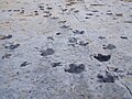 | 1973 | 39°40′52″N 105°11′33″W / 39.68100°N 105.19238°W / 39.68100; -105.19238 (Morrison-Golden Fossil Areas) | Jefferson | County, private | Site of major paleontological importance, unique for fossil footprints of reptiles, birds, and mammals. The site was expanded in 2011 to include the 19-acre (7.69 ha; 0.03 sq mi) Parfet Prehistoric Preserve in the city of Golden.[12] |
| 8 | Raton Mesa | 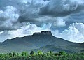 | 1967 | 37°05′52″N 104°27′46″W / 37.0978686°N 104.4627319°W / 37.0978686; -104.4627319 (Fishers Peak) | Las Animas | State, private | Protected by a thick lava cap, Raton Mesa has resisted the extensive erosion and weathering that has affected surrounding areas, providing an extreme contrast in geography. |
| 9 | Roxborough State Park |  | 1980 | 39°25′45″N 105°04′06″E / 39.42907°N 105.06841°E / 39.42907; 105.06841 (Roxborough Park) | Douglas | State | Site showcases typical Colorado Front Range sedimentary strata, as well as erosion of Fountain Formation sandstone in unusual patterns, extensive fossil remains and unusual plant populations. |
| 10 | Russell Lakes |  | 1975 | 37°56′41″N 106°07′12″W / 37.9448092°N 106.1199637°W / 37.9448092; -106.1199637 (Russell Lakes) | Saguache | Federal, private | Colorado's largest remaining bulrush marsh, now rare in the southern Rocky Mountains. Provides habitat for extensive flora and fauna, especially waterfowl. |
| 11 | Sand Creek |  | 1984 | 40°59′45″N 105°46′05″W / 40.9957404°N 105.7681064°W / 40.9957404; -105.7681064 (Chimney Rock) | Larimer | Federal, state, private | Shared with Wyoming, the site is one of North America's most impressive occurrences of cross-bedded sandstone and "topple blocks". Also a site of paleontological and biological significance. |
| 12 | Slumgullion Earthflow |  | 1965 | 37°59′55″N 107°14′42″W / 37.9986086°N 107.2450542°W / 37.9986086; -107.2450542 (Slumgullion Earthflow) | Hinsdale | Federal, private | A major example of the geologic process of mass wasting, a large flow of volcanic rock traveled from mountainside to valley to form Lake San Cristobal. The same process is occurring again, slowly covering the existing flow. Located on Bureau of Land Management land. |
| 13 | Spanish Peaks |  | 1976 | 37°22′32″N 104°59′37″W / 37.3756661°N 104.9936861°W / 37.3756661; -104.9936861 (West Spanish Peak) | Huerfano, Las Animas | Federal, private | Located in San Isabel National Forest, the site is an exceptional illustration of over 500 igneous dikes, many exposed, formed when molten igneous rock is forced into a fault before hardening. |
| 14 | Sulphur Cave and Spring | 2021 | 40°29′01″N 106°50′24″W / 40.4836973°N 106.8401306°W / 40.4836973; -106.8401306 (Sulphur Cave and Spring) | Routt | Municipal | Located in the Howelsen Hill Ski Area of Steamboat Springs, the site is a superb example of bacterially-mediated sulfuric acid speleogenesis. The cave contains many uncommon cave features, such as biovermiculations and snottites. | |
| 15 | Summit Lake |  | 1965 | 39°35′54″N 105°38′40″W / 39.5983532°N 105.6443243°W / 39.5983532; -105.6443243 (Summit Lake) | Clear Creek | Municipal | At almost 13,000 feet (4,000 m), the site contains an excellent example of alpine tundra in the contiguous US. Some of the plants that survive in this microclimate are usually found only in the Arctic Circle. |
| 16 | West Bijou Site | 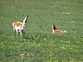 | 2016 | 39°40′52″N 104°44′09″W / 39.68100°N 104.73588°W / 39.68100; -104.73588 (West Bijou Site) | Arapahoe | Private | Part of the Plains Conservation Center, the site contains fossil and mineral evidence detailing the Cretaceous–Paleogene boundary, the Earth's most recent mass extinction event.[2] |
See also
 Environment portal
 Geography portal
 History portal
 United States portal
 Colorado portal


- List of protected areas of Colorado
- List of National Historic Landmarks in Colorado
- Bibliography of Colorado
- Geography of Colorado
- History of Colorado
- Index of Colorado-related articles
- List of Colorado-related lists
- Outline of Colorado
References
- General
- "National Registry of Natural Landmarks" (PDF). National Park Service. June 2009. pp. Introduction, 15–17. Retrieved 2014-01-06.
- Specific
- ^ "National Registry of Natural Landmarks" (PDF). National Park Service. June 2009. pp. Introduction, 15–17. Retrieved 2013-08-02.
- ^ a b "Interior Secretary Jewell Designates New National Natural Landmark" (PDF). National Park Service. November 17, 2016. Retrieved 2016-11-17.
- ^ "High Plateaus, Smelly Caverns, and Coastal Dunes, Meet the Nation's Newest Natural Landmarks (U.S. National Park Service)". www.nps.gov. Retrieved 2021-04-19.
- ^ "Colorado". National Park Service. June 28, 2012. Retrieved 2014-01-06.
- ^ "36 CFR Part 62: National Natural Landmarks Program, Final Rule" (PDF). Federal Register. May 12, 1999. Archived from the original (PDF) on 2013-02-17. Retrieved 2013-08-02.
- ^ "Frequently Asked Questions". National Park Service. Retrieved 2013-08-02.
- ^ "Big Spring Creek". National Park Service. June 28, 2012. Retrieved 2014-01-06.
- ^ "Garden of the Gods". www.nps.gov. Retrieved 2017-10-02.
- ^ "Spring 2013 Buds Two New NNLs and Expands an Existing Site". National Park Service. June 10, 2013. Retrieved 2014-01-06.
- ^ "Hanging Lake". National Park Service. June 28, 2012. Retrieved 2014-01-06.
- ^ "Indian Springs Trace Fossil Site". www.nps.gov. Retrieved 2017-10-02.
- ^ "Secretary Salazar Designates New National Natural Landmarks". National Park Service. June 15, 2011. Retrieved 2014-01-07.
External links
Colorado at Wikipedia's sister projects
 Media from Commons
 News from Wikinews
 Quotations from Wikiquote
 Travel information from Wikivoyage
- Colorado state government website
- Colorado Department of Natural Resources website
- Colorado Geological Survey website
- Colorado Department of Natural Resources website
- United States federal government website
- United States Department of the Interior website
- National Park Service website
- National Natural Landmarks Program
- National Park Service website
- United States Department of the Interior website
- v
- t
- e
Denver (capital)
- Bibliography
- Index
- Outline
- Climate change
- Colleges
- Coloradans
- Elections
- Federal lands
- Geography
- Government
- Historic places
- History
- Images
- Indian reservations
- Law
- Lists
- Military
- Mountains
- Municipalities
- Museums
- National Forests
- National Parks
- Paleontology
- Prehistoric sites
- Prehistory
- Protected areas
- Railroads
- Rivers
- Slavery
- Statistical areas
- Symbols
- Timeline
- Tourist attractions
- Towns
- Trails
- Transportation
- Wildernesses
- Alamosa
- Arvada
- Aspen
- Aurora
- Black Hawk
- Boulder
- Brighton
- Broomfield
- Brush
- Burlington
- Cañon City
- Castle Pines
- Centennial
- Central City
- Cherry Hills Village
- Colorado Springs
- Commerce City
- Cortez
- Craig
- Cripple Creek
- Dacono
- Delta
- Denver
- Durango
- Edgewater
- Englewood
- Evans
- Federal Heights
- Florence
- Fort Collins
- Fort Lupton
- Fort Morgan
- Fountain
- Fruita
- Glendale
- Glenwood Springs
- Golden
- Grand Junction
- Greeley
- Greenwood Village
- Gunnison
- Holyoke
- Idaho Springs
- La Junta
- Lafayette
- Lakewood
- Lamar
- Las Animas
- Leadville
- Littleton
- Lone Tree
- Longmont
- Louisville
- Loveland
- Manitou Springs
- Monte Vista
- Montrose
- Northglenn
- Ouray
- Pueblo
- Rifle
- Rocky Ford
- Salida
- Sheridan
- Steamboat Springs
- Sterling
- Thornton
- Trinidad
- Victor
- Walsenburg
- Westminster
- Wheat Ridge
- Woodland Park
- Wray
- Yuma
- Adams
- Alamosa
- Arapahoe
- Archuleta
- Baca
- Bent
- Boulder
- Broomfield
- Chaffee
- Cheyenne
- Clear Creek
- Conejos
- Costilla
- Crowley
- Custer
- Delta
- Denver
- Dolores
- Douglas
- Eagle
- El Paso
- Elbert
- Fremont
- Garfield
- Gilpin
- Grand
- Gunnison
- Hinsdale
- Huerfano
- Jackson
- Jefferson
- Kiowa
- Kit Carson
- La Plata
- Lake
- Larimer
- Las Animas
- Lincoln
- Logan
- Mesa
- Mineral
- Moffat
- Montezuma
- Montrose
- Morgan
- Otero
- Ouray
- Park
- Phillips
- Pitkin
- Prowers
- Pueblo
- Rio Blanco
- Rio Grande
- Routt
- Saguache
- San Juan
- San Miguel
- Sedgwick
- Summit
- Teller
- Washington
- Weld
- Yuma
- Central Colorado
- Eastern Plains
- Colorado Mineral Belt
- Colorado Piedmont
- Colorado Plateau
- Colorado Western Slope
- Denver Metropolitan Area
- Four Corners Region
- Front Range Urban Corridor
- High Plains
- North Central Colorado Urban Area
- Northwestern Colorado
- San Luis Valley
- South-Central Colorado
- South Central Colorado Urban Area
- Southern Rocky Mountains
- Southwest Colorado
 Colorado portal
38°59′50″N 105°32′52″W / 38.9972°N 105.5478°W / 38.9972; -105.5478 (State of Colorado)


