Sibayo District
District in Arequipa, Peru
15°29′12.1″S 71°27′25.7″W / 15.486694°S 71.457139°W / -15.486694; -71.457139 Peru
Peru (2005 census)
Sibayo District is one of twenty districts of the province Caylloma in Peru.[1] It is adjacent to Callalli and crossed by the Colca River on one side.
Ethnic groups
The people in the district are mainly indigenous citizens of Quechua descent. Quechua is the language which the majority of the population (55.45%) learnt to speak in childhood, 44.41% of the residents started speaking using the Spanish language (2007 Peru Census).[2]
-
 The village of Sibayo as seen from above
 -
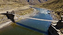 Sibayo's suspended pedestrian bridge
 -
 The main plaza in Sibayo as seen from above
 -
 The entrance to Sibayo in the Colca Canyon
 -
 Sibayo's ruins next to the Colca river.


Climate
| Climate data for Sibayo, elevation 3,816 m (12,520 ft), (1991–2020) | |||||||||||||
|---|---|---|---|---|---|---|---|---|---|---|---|---|---|
| Month | Jan | Feb | Mar | Apr | May | Jun | Jul | Aug | Sep | Oct | Nov | Dec | Year |
| Mean daily maximum °C (°F) | 18.1 (64.6) | 17.7 (63.9) | 17.9 (64.2) | 18.2 (64.8) | 17.8 (64.0) | 17.2 (63.0) | 16.9 (62.4) | 18.1 (64.6) | 19.0 (66.2) | 20.0 (68.0) | 20.8 (69.4) | 19.7 (67.5) | 18.5 (65.2) |
| Mean daily minimum °C (°F) | 3.6 (38.5) | 3.8 (38.8) | 3.4 (38.1) | 0.9 (33.6) | −4.0 (24.8) | −6.7 (19.9) | −6.9 (19.6) | −5.7 (21.7) | −3.4 (25.9) | −1.4 (29.5) | −0.5 (31.1) | 1.9 (35.4) | −1.2 (29.7) |
| Average precipitation mm (inches) | 156.0 (6.14) | 156.5 (6.16) | 106.9 (4.21) | 37.5 (1.48) | 4.5 (0.18) | 3.2 (0.13) | 5.5 (0.22) | 5.9 (0.23) | 9.9 (0.39) | 17.0 (0.67) | 21.2 (0.83) | 80.1 (3.15) | 604.2 (23.79) |
| Source: National Meteorology and Hydrology Service of Peru[3] | |||||||||||||
See also
References
- ^ (in Spanish) Instituto Nacional de Estadística e Informática. Banco de Información Distrital Archived 2008-04-23 at the Wayback Machine. Retrieved April 11, 2008.
- ^ inei.gob.pe Archived 2013-01-27 at the Wayback Machine INEI, Peru, Censos Nacionales 2007, Frequencias: Preguntas de Población: Idioma o lengua con el que aprendió hablar (in Spanish)
- ^ "Normales Climaticás Estándares y Medias 1991-2020". National Meteorology and Hydrology Service of Peru. Archived from the original on 21 August 2023. Retrieved 27 June 2024.
- v
- t
- e

- Districts of Arequipa Region
- Peru

- Alto Selva Alegre
- Arequipa
- Cayma
- Cerro Colorado
- Characato
- Chiguata
- Jacobo Hunter
- José Luis Bustamante
- La Joya
- Mariano Melgar
- Miraflores
- Mollebaya
- Paucarpata
- Pocsi
- Polobaya
- Quequeña
- Sabandía
- Sachaca
- San Juan de Siguas
- San Juan de Tarucani
- Santa Isabel de Siguas
- Santa Rita de Siguas
- Socabaya
- Tiabaya
- Uchumayo
- Vitor
- Yanahuara
- Yarabamba
- Yura
15°29′35″S 71°44′46″W / 15.4931°S 71.7462°W / -15.4931; -71.7462
 | This Arequipa Region geography article is a stub. You can help Wikipedia by expanding it. |
- v
- t
- e


