Lari District
District in Arequipa, Peru
Lari | |
|---|---|
District | |
 Colca River with the village of Lari in the background | |
| Country |  Peru Peru |
| Region | Arequipa |
| Province | Caylloma |
| Capital | Lari |
| Government | |
| • Mayor | Abel Abdon Llallacachi Silloca |
| Area | |
| • Total | 384.02 km2 (148.27 sq mi) |
| Elevation | 3,330 m (10,930 ft) |
| Population (2005 census) | |
| • Total | 1,370 |
| • Density | 3.6/km2 (9.2/sq mi) |
| Time zone | UTC-5 (PET) |
| UBIGEO | 040510 |
Lari District is one of twenty districts of the province Caylloma in Peru.[1]
Geography
The Ch'ila mountain range traverses the district. One of the highest elevations of the district is Mismi at 5,597 m (18,363 ft) above sea level. Other mountains are listed below:[2]
|
|
Images
-
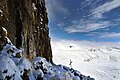 Mismi on the border of the districts of Lari and Ichupampa
 -
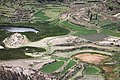 Fields at the Colca River in the Lari District


See also
References
- ^ (in Spanish) Instituto Nacional de Estadística e Informática. Banco de Información Distrital Archived 2008-04-23 at the Wayback Machine. Retrieved April 11, 2008.
- ^ escale.minedu.gob.pe - UGEL maps of the Caylloma Province 1 and 2 (Arequipa Region)
- v
- t
- e

- Districts of Arequipa Region
- Peru

- Alto Selva Alegre
- Arequipa
- Cayma
- Cerro Colorado
- Characato
- Chiguata
- Jacobo Hunter
- José Luis Bustamante
- La Joya
- Mariano Melgar
- Miraflores
- Mollebaya
- Paucarpata
- Pocsi
- Polobaya
- Quequeña
- Sabandía
- Sachaca
- San Juan de Siguas
- San Juan de Tarucani
- Santa Isabel de Siguas
- Santa Rita de Siguas
- Socabaya
- Tiabaya
- Uchumayo
- Vitor
- Yanahuara
- Yarabamba
- Yura
15°37′17″S 71°46′26″W / 15.6214°S 71.7738°W / -15.6214; -71.7738
 | This Arequipa Region geography article is a stub. You can help Wikipedia by expanding it. |
- v
- t
- e


