Spotsylvania County
County in de Verenigde Staten  | |||
|---|---|---|---|
 | |||
 | |||
| Situering | |||
| Staat | Virginia | ||
| Tijdzone | Eastern Standard Time (UTC−5) | ||
| Coördinaten | 38°10'48"NB, 77°39'0"WL | ||
| Algemeen | |||
| Oppervlakte | 1.100 km² | ||
| - land | 1.070 km² | ||
| - water | 30 km² | ||
| Inwoners (2000) | 90.395 (84 inw./km²) | ||
| Overig | |||
| Zetel | Spotsylvania Courthouse | ||
| FIPS-code | 51177 | ||
| Opgericht | 1721 | ||
| Website | spotsylvania.va.us | ||
| Foto's | |||
 | |||
| Spotsylvania County Courthouse | |||
 Bevolkingspiramide Spotsylvania County | |||
| Statistieken volkstelling Spotsylvania County | |||
| |||

Spotsylvania County is een van de 95 county's in de Amerikaanse staat Virginia. Daarnaast kent Virginia 39 onafhankelijke steden die niet tot county's behoren.
De county heeft een landoppervlakte van 1.038 km² en telt 90.395 inwoners (volkstelling 2000). De hoofdplaats is Spotsylvania Courthouse.
Geschiedenis
Amerikaanse Burgeroorlog
Tussen 30 april en 6 mei 1863 vond in Spotsylvania County de Slag bij Chancellorsville plaats. Een jaar later waren er nog twee veldslagen, de Slag in de Wildernis (5-7 mei 1864). Deze slag vond plaats in Spotsylvania en Orange County. En direct erna volgde de Slag bij Spotsylvania Court House (8-21 mei 1864).
-

-
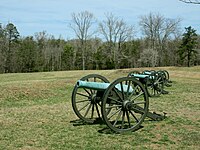 De artillerie op het slagveld


Bevolkingsontwikkeling
| Historische inwonertallen | |||
|---|---|---|---|
| Jaar | Inwoners | % ± | |
| 1900 | 9.239 | — | |
| 1910 | 9.935 | 7,5% | |
| 1920 | 10.571 | 6,4% | |
| 1930 | 10.056 | −4,9% | |
| 1940 | 9.905 | −1,5% | |
| 1950 | 11.920 | 20,3% | |
| 1960 | 13.819 | 15,9% | |
| 1970 | 16.424 | 18,9% | |
| 1980 | 34.435 | 109,7% | |
| 1990 | 57.403 | 66,7% | |
| 2000 | 90.395 | 57,5% | |
| Bron: (en) Historical Decennial Census Population | |||
Externe link
- (en) Website van Spotsylvania County
County's:
Accomack County · Albemarle County · Alleghany County · Amelia County · Amherst County · Appomattox County · Arlington County · Augusta County · Bath County · Bedford County · Bland County · Botetourt County · Brunswick County · Buchanan County · Buckingham County · Campbell County · Caroline County · Carroll County · Charles City County · Charlotte County · Chesterfield County · Clarke County · Craig County · Culpeper County · Cunmberland County · Dickenson County · Dinwiddie County · Essex County · Fairfax County · Fauquier County · Floyd County · Fluvanna County · Franklin County · Frederick County · Giles County · Gloucester County · Goochland County · Grayson County · Greene County · Greensville County · Halifax County · Hanover County · Henrico County · Henry County · Highland County · Isle of Wight County · James City County · King and Queen County · King George County · King William County · Lancaster County · Lee County · Loudoun County · Louisa County · Lunenburg County · Madison County · Mathews County · Mecklenburg County · Middlesex County · Montgomery County · Nelson County · New Kent County · Northampton County · Northumberland County · Nottoway County · Orange County · Page County · Patrick County · Pittsylvania County · Powhatan County · Prince Edward County · Prince George County · Prince William County · Pulaski County · Rappahannock County · Richmond County · Roanoke County · Rockbridge County · Rockingham County · Russell County · Scott County · Shenandoah County · Smyth County · Southampton County · Spotsylvania County · Stafford County · Surry County · Sussex County · Tazewell County · Warren County · Washington County · Westmoreland County · Wise County · Wythe County · York County
Onafhankelijke steden:
Alexandria · Bristol · Buena Vista · Charlottesville · Chesapeake · Colonial Heights · Covington · Danville · Emporia · Fairfax · Falls Church · Franklin · Fredericksburg · Galax · Hampton · Harrisonburg · Hopewell · Lexington · Lynchburg · Manassas · Manassas Park · Martinsville · Newport News · Norfolk · Norton · Petersburg · Poquoson · Portsmouth · Radford · Richmond · Roanoke · Salem · Staunton · Suffolk · Virginia Beach · Waynesboro · Williamsburg · Winchester


