North East England
Regio in Engeland  | |||
|---|---|---|---|
 | |||
| Coördinaten | 55°0'NB, 1°52'WL | ||
| Algemeen | |||
| Oppervlakte | 8574,4435[1] km² | ||
| Inwoners (2011) | 2.597.000[2] (302 inw./km²) | ||
| Hoofdplaats | Newcastle upon Tyne | ||
| Overig | |||
| ONS-code | E12000001 | ||
| |||

North East England of Noordoost-Engeland is een regio van Engeland met ongeveer 2.600.000 inwoners en daarmee de regio met de minste inwoners. De regio staat ook wel bekend onder haar historische naam Bernicia.
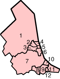
Bestuurlijke indeling
De regio bestaat uit de volgende lokaal bestuurde gebieden (graafschappen of unitary authorities):
|
| ||||||||||||||||||||||||||||||||||
Bronnen, noten en/of referenties

Bestuurlijke indeling van het Verenigd Koninkrijk: landen en regio's
Engeland ·  Schotland ·
  Noord-Ierland ·
  Wales
Wales
Regio's van Engeland: East of England · East Midlands · Londen · North East · North West · South East · South West · West Midlands · Yorkshire and the Humber


