Peta timbul
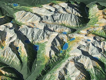
Sebuah Peta timbul atau Model permukaan adalah representasi tiga dimensi dari (biasanya) suatu medan yang berwujud sebagai artefak fisik. Saat mewakili medan, matra vertikal biasanya dilebihkan oleh faktor antara lima sampai sepuluh kali lipat, agar lebih cepat mengenali medan yang dimaksud secara visual.
Referensi
- de Crespigny, Rafe. (2007). A Biographical Dictionary of Later Han to the Three Kingdoms (23–220 AD). Leiden: Koninklijke Brill. ISBN 90-04-15605-4.
- Ebrey, Patricia Buckley, Anne Walthall, James B. Palais (2006). East Asia: A Cultural, Social, and Political History. Boston: Houghton Mifflin Company. ISBN 0-618-13384-4.
- Needham, Joseph. (1986). Science and Civilization in China: Volume 3, Mathematics and the Sciences of the Heavens and the Earth. Taipei: Caves Books, Ltd.
- Sivin, Nathan (1995). Science in Ancient China: Researches and Reflections. Brookfield, Vermont: VARIORUM, Ashgate Publishing.
Pranala luar
- Terrain Models, a website of the Institute of Cartography at ETH Zurich
- Library of Congress: Geography and Maps - Globes and Terrain Models
- Report of the Relief Map Department, G-2-C, G.H.Q., of the American Expeditionary Forces
- Allan McCollum: The Topographical Model Donation Project
- How to build a landscape-model Diarsipkan 2018-01-14 di Wayback Machine. by Konrad Weber
- Participatory Avenues a web site dedicated to the participatory manufacture of raised relief models in the context of participatory planning, development and advocacy
- Adding the Third Dimension, an article (PDF 744KB) that describes ways of creating maps that "effectively present the third dimension."


