Ostrobothnia Tengah
Ostrobothnia Tengah Keski-Pohjanmaacode: fi is deprecated (Finlandia) Mellersta Österbottencode: sv is deprecated (Swedia) | |
|---|---|
Region | |
| Region Ostrobothnia Tengah Keski-Pohjanmaan maakunta Landskapet Mellersta Österbotten | |
 Bendera  Lambang kebesaran | |
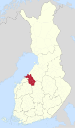 Ostrobothnia Tengah di peta Finlandia | |
| Koordinat: 63°30′N 24°15′E / 63.500°N 24.250°E / 63.500; 24.250Koordinat: 63°30′N 24°15′E / 63.500°N 24.250°E / 63.500; 24.250 | |
| Negara | Finlandia |
| Provinsi historis | Ostrobothnia |
| Ibukota | Kokkola |
| Luas | |
| • Total | 5.706,39 km2 (2,203,25 sq mi) |
| Populasi (2019) | |
| • Total | 68,158 |
| • Kepadatan | 12/km2 (31/sq mi) |
| PDB | |
| • Total | €2,425 miliar (2015) |
| • Per kapita | €35.181 (2015) |
| Zona waktu | UTC+2 (EET) |
| • Musim panas (DST) | UTC+3 (EEST) |
| Kode ISO 3166 | FI-07 |
| NUTS | 1A1 |
| Burung regional | Skylark (Alauda arvensis) |
| Ikan regional | Ikan putih eropa (Coregonus lavaretus) |
| Bunga regional | Bluebell (Harebell) |
| Batu regional | Gneiss |
| Danau regional | Danau Lestijärvi |
| Situs web | keski-pohjanmaa.fi |
Ostrobothnia Tengah (bahasa Finlandia: Keski-Pohjanmaa; bahasa Swedia: Mellersta Österbotten) adalah sebuah region di Finlandia. Region berbatasan dengan region Ostrobothnia, Ostrobothnia Utara, Finlandia Tengah dan Ostrobothnia Selatan.[2]
Rujukan
- ^ Regions and Cities > Regional Statistics > Regional Economy > Regional GDP per Capita, OECD.Stats. Accessed on 16 November 2018.
- ^ Nordberg, Kenneth (2016-11-23). Revolutionizing Economic and Democratic Systems: Reinventing the Third Way (dalam bahasa Inggris). Springer. hlm. 70–71. ISBN 978-3-319-40633-6.
Pranala luar
Wikimedia Commons memiliki media mengenai Central Ostrobothnia.
- Situs web Dewan Regional Ostrobothnia Tengah
| ||
|---|---|---|
| Laplandia |  | |
| Oulu | ||
| Finlandia Barat | Ostrobothnia Tengah · Ostrobothnia · Ostrobothnia Selatan · Finlandia Tengah · Pirkanmaa · Satakunta · Varsinais-Suomi | |
| Finlandia Timur | ||
| Finlandia Selatan | ||
| Åland | Åland | |

| Pengawasan otoritas |
|
|---|


