Daftar county di Washington

AD
AS
BE
CH
CL
CK
CO
CW
DO
FE
FR
GA
GR
GH
IS
JE
KG
KI
KT
KL
LE
LN
MA
OK
PA
PE
PC
SJ
SK
SM
SN
SP
ST
TH
WK
WL
WH
WT
YA
Berikut ini adalah daftar lengkap 39 county di negara bagian Washington, Amerika Serikat.
| Wilayah | Kode FIPS[1] | Ibukota[2] | Didirikan[2] | Asal[3] | Etimologi[3] | Penduduk[2] | Luas[2] | Peta |
|---|---|---|---|---|---|---|---|---|
| Wilayah Adams | 001 | Ritzville | 1883 | Whitman County | John Adams (1735-1826), second President of the United States | &&&&&&&&&&016428.&&&&&016.428 | &&&&&&&&&&&01925.&&&&&01.925 sq mi (4,986 km²) | 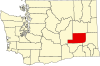 |
| Wilayah Asotin | 003 | Asotin | 1883 | Garfield County | The Nez Percé name for Eel Creek | &&&&&&&&&&020551.&&&&&020.551 | &&&&&&&&&&&&0636.&&&&&0636 sq mi (&&&&&&&&&&&01647.&&&&&01.647 km2) |  |
| Wilayah Benton | 005 | Prosser | 1905 | Yakima and Klickitat Counties | Thomas Hart Benton (1782 – 1858), a Missouri U.S. Senator | &&&&&&&&&0142475.&&&&&0142.475 | &&&&&&&&&&&01703.&&&&&01.703 sq mi (&&&&&&&&&&&04411.&&&&&04.411 km2) |  |
| Wilayah Chelan | 007 | Wenatchee | 1899 | Okanogan and Kittitas Counties | A Native American word meaning deep water, likely referring to Lake Chelan | &&&&&&&&&&066616.&&&&&066.616 | &&&&&&&&&&&02922.&&&&&02.922 sq mi (&&&&&&&&&&&07568.&&&&&07.568 km2) |  |
| Wilayah Clallam | 009 | Port Angeles | 1854 | Jefferson County | A Klallam word meaning "the strong people" | &&&&&&&&&&064525.&&&&&064.525 | &&&&&&&&&&&01745.&&&&&01.745 sq mi (&&&&&&&&&&&04520.&&&&&04.520 km2) |  |
| Wilayah Clark | 011 | Vancouver | 1845 | Original county | William Clark (1770 – 1838), the co-captain of the Lewis and Clark Expedition | &&&&&&&&&0345238.&&&&&0345.238 | &&&&&&&&&&&&0628.&&&&&0628 sq mi (&&&&&&&&&&&01627.&&&&&01.627 km2) |  |
| Wilayah Columbia | 013 | Dayton | 1875 | Walla Walla County | The Columbia River | &&&&&&&&&&&04064.&&&&&04.064 | &&&&&&&&&&&&0869.&&&&&0869 sq mi (&&&&&&&&&&&02251.&&&&&02.251 km2) | 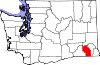 |
| Wilayah Cowlitz | 015 | Kelso | 1854 | Original county | Cowlitz, an Indian tribe | &&&&&&&&&&092948.&&&&&092.948 | &&&&&&&&&&&01139.&&&&&01.139 sq mi (&&&&&&&&&&&02950.&&&&&02.950 km2) |  |
| Wilayah Douglas | 017 | Waterville | 1883 | Lincoln County | Stephen A. Douglas (1813 - 1861), American statesman. | &&&&&&&&&&032603.&&&&&032.603 | &&&&&&&&&&&01821.&&&&&01.821 sq mi (&&&&&&&&&&&04716.&&&&&04.716 km2) | 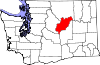 |
| Wilayah Ferry | 019 | Republic | 1899 | Stevens County | Elisha P. Ferry (1825 - 1895), first Governor of Washington State | &&&&&&&&&&&07260.&&&&&07.260 | &&&&&&&&&&&02204.&&&&&02.204 sq mi (&&&&&&&&&&&05708.&&&&&05.708 km2) |  |
| Wilayah Franklin | 021 | Pasco | 1883 | Whitman County | Benjamin Franklin | &&&&&&&&&&049347.&&&&&049.347 | &&&&&&&&&&&01242.&&&&&01.242 sq mi (&&&&&&&&&&&03217.&&&&&03.217 km2) |  |
| Wilayah Garfield | 023 | Pomeroy | 1881 | Columbia County | James A. Garfield | &&&&&&&&&&&02397.&&&&&02.397 | &&&&&&&&&&&&0710.&&&&&0710 sq mi (&&&&&&&&&&&01839.&&&&&01.839 km2) |  |
| Wilayah Grant | 025 | Ephrata | 1909 | Douglas County | Ulysses S. Grant | &&&&&&&&&&074698.&&&&&074.698 | &&&&&&&&&&&02681.&&&&&02.681 sq mi (&&&&&&&&&&&06944.&&&&&06.944 km2) |  |
| Wilayah Grays Harbor | 027 | Montesano | 1854 | Thurston County | Grays Harbor, a body of water named after Robert Gray | &&&&&&&&&&067194.&&&&&067.194 | &&&&&&&&&&&01917.&&&&&01.917 sq mi (&&&&&&&&&&&04965.&&&&&04.965 km2) |  |
| Wilayah Island | 029 | Coupeville | 1853 | Thurston County | Whidbey and Camano Islands | &&&&&&&&&&071558.&&&&&071.558 | &&&&&&&&&&&&0209.&&&&&0209 sq mi (&&&&&&&&&&&&0541.&&&&&0541 km2) |  |
| Wilayah Jefferson | 031 | Port Townsend | 1852 | Thurston County | Thomas Jefferson | &&&&&&&&&&025953.&&&&&025.953 | &&&&&&&&&&&01809.&&&&&01.809 sq mi (&&&&&&&&&&&04685.&&&&&04.685 km2) | 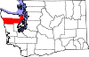 |
| Wilayah King | 033 | Seattle | 1852 | Thurston County | William Rufus King, vice president of the United States under Franklin Pierce; officially renamed in 1986 after Martin Luther King, Jr. | &&&&&&&&01737034.&&&&&01.737.034 | &&&&&&&&&&&02126.&&&&&02.126 sq mi (&&&&&&&&&&&05506.&&&&&05.506 km2) |  |
| Wilayah Kitsap | 035 | Port Orchard | 1857 | King and Jefferson Counties | Chief Kitsap | &&&&&&&&&0231969.&&&&&0231.969 | &&&&&&&&&&&&0396.&&&&&0396 sq mi (&&&&&&&&&&&01026.&&&&&01.026 km2) |  |
| Wilayah Kittitas | 037 | Ellensburg | 1883 | Yakima County | Kittitas tribe word of uncertain meaning | &&&&&&&&&&033362.&&&&&033.362 | &&&&&&&&&&&02297.&&&&&02.297 sq mi (&&&&&&&&&&&05949.&&&&&05.949 km2) |  |
| Wilayah Klickitat | 039 | Goldendale | 1859 | Walla Walla County | Klickitat Tribe | &&&&&&&&&&019161.&&&&&019.161 | &&&&&&&&&&&01872.&&&&&01.872 sq mi (&&&&&&&&&&&04848.&&&&&04.848 km2) | 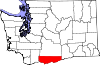 |
| Wilayah Lewis | 041 | Chehalis | 1845 | Original county | Meriwether Lewis (1774 – 1809), the co-captain of the Lewis and Clark Expedition | &&&&&&&&&&068600.&&&&&068.600 | &&&&&&&&&&&02408.&&&&&02.408 sq mi (&&&&&&&&&&&06237.&&&&&06.237 km2) |  |
| Wilayah Lincoln | 043 | Davenport | 1883 | Whitman County | Abraham Lincoln | &&&&&&&&&&010184.&&&&&010.184 | &&&&&&&&&&&02311.&&&&&02.311 sq mi (&&&&&&&&&&&05985.&&&&&05.985 km2) |  |
| Wilayah Mason | 045 | Shelton | 1854 | King County | C.H. Mason, first Secretary of Washington Territory | &&&&&&&&&&049405.&&&&&049.405 | &&&&&&&&&&&&0961.&&&&&0961 sq mi (&&&&&&&&&&&02489.&&&&&02.489 km2) |  |
| Wilayah Okanogan | 047 | Okanogan | 1888 | Stevens County | A Salish Native American word meaning rendezvous | &&&&&&&&&&039564.&&&&&039.564 | &&&&&&&&&&&05268.&&&&&05.268 sq mi (&&&&&&&&&&013644.&&&&&013.644 km2) |  |
| Wilayah Pacific | 049 | South Bend | 1851 | Lewis County | The Pacific Ocean | &&&&&&&&&&020984.&&&&&020.984 | &&&&&&&&&&&&0975.&&&&&0975 sq mi (&&&&&&&&&&&02525.&&&&&02.525 km2) | 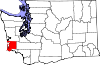 |
| Wilayah Pend Oreille | 051 | Newport | 1911 | Stevens County | The Pend d'Oreille Native American tribe | &&&&&&&&&&011732.&&&&&011.732 | &&&&&&&&&&&01400.&&&&&01.400 sq mi (&&&&&&&&&&&03626.&&&&&03.626 km2) |  |
| Wilayah Pierce | 053 | Tacoma | 1852 | Thurston County | Franklin Pierce, 14th President of the United States | &&&&&&&&&0700820.&&&&&0700.820 | &&&&&&&&&&&01676.&&&&&01.676 sq mi (&&&&&&&&&&&04341.&&&&&04.341 km2) |  |
| Wilayah San Juan | 055 | Friday Harbor | 1873 | Whatcom County | San Juan Island | &&&&&&&&&&014077.&&&&&014.077 | &&&&&&&&&&&&0175.&&&&&0175 sq mi (&&&&&&&&&&&&0453.&&&&&0453 km2) |  |
| Wilayah Skagit | 057 | Mount Vernon | 1883 | Whatcom County | The Skagit Native American tribe | &&&&&&&&&0102979.&&&&&0102.979 | &&&&&&&&&&&01735.&&&&&01.735 sq mi (&&&&&&&&&&&04494.&&&&&04.494 km2) |  |
| Wilayah Skamania | 059 | Stevenson | 1854 | Clark County | A Chinookan word meaning "swift water" | &&&&&&&&&&&09872.&&&&&09.872 | &&&&&&&&&&&01656.&&&&&01.656 sq mi (&&&&&&&&&&&04289.&&&&&04.289 km2) |  |
| Wilayah Snohomish | 061 | Everett | 1861 | Island County | The Snohomish tribe | &&&&&&&&&0606024.&&&&&0606.024 | &&&&&&&&&&&02090.&&&&&02.090 sq mi (&&&&&&&&&&&05413.&&&&&05.413 km2) |  |
| Wilayah Spokane | 063 | Spokane | 1879 | Stevens County | The Spokane Native American tribe | &&&&&&&&&0417939.&&&&&0417.939 | &&&&&&&&&&&01764.&&&&&01.764 sq mi (&&&&&&&&&&&04569.&&&&&04.569 km2) |  |
| Wilayah Stevens | 065 | Colville | 1863 | Walla Walla County | Isaac Ingalls Stevens, the first governor of the Washington Territory. | &&&&&&&&&&040066.&&&&&040.066 | &&&&&&&&&&&02478.&&&&&02.478 sq mi (&&&&&&&&&&&06418.&&&&&06.418 km2) |  |
| Wilayah Thurston | 067 | Olympia | 1852 | Lewis County | Samuel R. Thurston, the Oregon Territory's first delegate to Congress | &&&&&&&&&0207355.&&&&&0207.355 | &&&&&&&&&&&&0727.&&&&&0727 sq mi (&&&&&&&&&&&01883.&&&&&01.883 km2) |  |
| Wilayah Wahkiakum | 069 | Cathlamet | 1854 | Cowlitz County | Leader of Wahkiakum ("Tall Timber"), Native American tribe | &&&&&&&&&&&03824.&&&&&03.824 | &&&&&&&&&&&&0264.&&&&&0264 sq mi (&&&&&&&&&&&&0684.&&&&&0684 km2) | 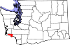 |
| Wilayah Walla Walla | 071 | Walla Walla | 1854 | Skamania County | The Walla Walla Native American tribe, and also another name for running water | &&&&&&&&&&055180.&&&&&055.180 | &&&&&&&&&&&01270.&&&&&01.270 sq mi (&&&&&&&&&&&03289.&&&&&03.289 km2) |  |
| Wilayah Whatcom | 073 | Bellingham | 1854 | Island County | Nooksack word meaning "noisy water" | &&&&&&&&&0166814.&&&&&0166.814 | &&&&&&&&&&&02120.&&&&&02.120 sq mi (&&&&&&&&&&&05491.&&&&&05.491 km2) |  |
| Wilayah Whitman | 075 | Colfax | 1871 | Stevens County | Marcus Whitman, a Presbyterian missionary. | &&&&&&&&&&040740.&&&&&040.740 | &&&&&&&&&&&02159.&&&&&02.159 sq mi (&&&&&&&&&&&05592.&&&&&05.592 km2) |  |
| Wilayah Yakima | 077 | Yakima | 1865 | Ferguson County (defunct) | The Yakama Native American tribe | &&&&&&&&&0222581.&&&&&0222.581 | &&&&&&&&&&&04296.&&&&&04.296 sq mi (&&&&&&&&&&011127.&&&&&011.127 km2) |  |
Referensi
- ^ "EPA County FIPS Code Listing". US Environmental Protection Agency. Diakses tanggal 2008-05-06.
- ^ a b c d National Association of Counties. "NACo - Find a county". Diarsipkan dari versi asli tanggal 2007-10-25. Diakses tanggal 2008-05-06.
- ^ a b "Washington Counties". Online Encyclopedia of Washington State History. HistoryLink.org. Diakses tanggal 2008-05-06.
| |
|---|---|
Olympia (ibu kota) | |
| Topik |
|
| Wilayah |
|
| Kota besar | |
| Kota kecil |
|
| County |
|

Lihat pula
- Daftar tempat di Washington
- Daftar kota di Washington


