Wingham Brush Nature Reserve
Protected area in New South Wales, Australia
31°52.2′S 152°22.8′E / 31.8700°S 152.3800°E / -31.8700; 152.3800New South Wales
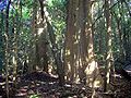
The Wingham Brush Nature Reserve is a protected nature reserve that is located in the Mid North Coast region of New South Wales, in eastern Australia. The 8-hectare (20-acre) reserve is a rare[2] example of sub tropical lowland rainforest and is situated on the Manning River.
Features
Much of Australia's lowland sub tropical rainforest was cleared for housing and agriculture, leaving only small patches remaining, such as at Wingham Brush The soils are derived from the Manning River. These alluvial soils are enriched from basaltic deposits upstream at Barrington Tops and the Comboyne and Bulga Plateaux. The average annual rainfall is 1,100 millimetres (43 in) at Wingham.[3]
Fauna
The most obvious mammal species in the rainforest is the grey-headed flying fox. Many other species of bats occur here too. Noteworthy birds occurring here include the osprey, green catbird, wompoo fruit-dove and brush turkey. Nocturnal gliders and possums occur in the rainforest, as do many species of reptiles, such as the land mullet.[4]
Flora
The reserve contains 76 species of trees. Most evident in Wingham Brush are the large Moreton Bay figs. Another very common plant is the giant stinging tree. The largest known blush walnut was measured at 37 metres tall, with a base of over a metre wide. Other significant tree species include white cedar, black apple, white walnut, shiny-leaved stinging tree, native elm, hairy rosewood and black booyong.
Rainforest regeneration
Rainforest regeneration programmes have been put in place to encourage local rainforest species and suppress the problem of invasive weeds.[5] The forest was badly infested with weeds until local residents decided to act in 1980. The vines Madeira vine and cats claw creeper were particularly damaging. After the cleanup, the previously degraded area was transformed back into pristine rainforest. The "Wingham Brush method" is an internationally recognised technique for rainforest regeneration.[citation needed]
Indigenous Australians
Wingan in the local indigenous Biripi language means "where bats come to drink".[4] Indigenous Australians regularly visited the rainforest for the collection of food, medicinal purposes, the collection of fibres for making bags and nets and social gatherings. The rainforest has spiritual significance to local indigenous people.
Gallery
-
 Giant stinging trees at Wingham Brush
 -
 Native elm at Wingham Brush
 -
 Black apple beside the boardwalk at Wingham Brush
 -
 Red kamala at Wingham Brush


See also
 New South Wales portal
 environment portal


References
- ^ a b "Wingham Brush Nature Reserve: Park management". Office of Environment and Heritage. Government of New South Wales. Retrieved 27 September 2014.
- ^ "Lowland rainforest on floodplain in the NSW North Coast Bioregion - endangered ecological community listing". Government of New South Wales.
- ^ Stockard, J. D. (1996). Rainforest Regeneration at Wingham Brush 1980-1996 (PDF). Eleventh Australian Weeds Conference Proceedings (PDF).
- ^ a b "Wingham Brush Nature Reserve: Pamphlet". NSW National Parks and Wildlife Service (PDF). Government of New South Wales. August 2011.
- ^ Floyd, A. G. (1990). Australian Rainforests of New South Wales. Vol. 2. ISBN 0-949324-32-9.
External links
- "Wingham Brush Nature Reserve: Plan of management" (PDF). NSW National Parks and Wildlife Service (PDF). Government of New South Wales. 5 November 2003. ISBN 0-7313-6569-0.
- v
- t
- e
Nature reserves of New South Wales, Australia
- Abercrombie Caves
- Arakoola
- Avisford
- Barton
- Binnaway
- Boomi
- Boomi West
- Borenore Caves
- Boronga
- Brigalow Park
- Budelah
- Careunga
- Coolbaggie
- Copperhannia
- Dapper
- Donnybrook
- Dural
- Eugowra
- Freemantle
- Gamilaroi
- Girralang
- Jenolan Caves
- Kemps Creek
- Kirramingly
- Koorawatha
- Kuma
- Macquarie Marshes
- Midkin
- Mugii Murum-ban
- Munghorn Gap
- Narran Lake
- Pilliga
- Planchonella
- The Rock
- Tollingo
- Turallo
- Wambool
- Weetalibah
- Winburndale
- Woggoon
- Wongarbon
- Yaegl
- Yarringully
Mid North Coast
- Awabakal
- Baalijin
- Back River
- Bagul Waajaarr
- Bandicoot Island
- Bird Island
- Bollanolla
- Boonanghi
- Boondelbah
- Boorganna
- Bowraville
- Bretti
- Brimbin
- Bugan
- Burning Mountain
- Bushy Island
- Camels Hump
- Camerons Gorge
- Cedar Brush
- Coocumbac Island
- Coolongolook
- Cooperabung Creek
- Coramba
- Corrie Island
- Coxcomb
- Darawank
- Fifes Knob
- Fishermans Bend
- Gads Sugarloaf
- Ganay
- Garby
- Goonook
- Hexham Swamp
- Jaaningga
- Jagun
- Jasper
- John Gould
- Juugawaarri
- Karuah
- Kattang
- Khappinghat
- Khatambuhl
- Killabakh
- Killarney
- Kooragang
- Koorebang
- Kororo
- Lake Innes
- Limeburners Creek
- Little Broughton Island
- Macquarie
- Mernot
- Mills Island
- Moffats Swamp
- Monkerai
- Monkeycot
- Moon Island
- Moonee Beach
- Mount Seaview
- Muttonbird Island
- Ngambaa
- North Rock
- One Tree Island
- Pambalong
- Pee Dee
- Pulbah Island
- Queens Lake
- Rawdon Creek
- Regatta Island
- Running Creek
- Seaham Swamp
- Seal Rocks
- Skillion
- Snapper Island
- Stormpetrel
- Talawahl
- The Castles
- The Glen
- Tilligerry
- Tingira Heights
- Tomalla
- Towibakh
- Valla
- Wallabadah
- Wallamba
- Wallaroo
- Wallis Island
- Weelah
- Willi Willi Caves
- Wingen Maid
- Wingham Brush
- Worimi
- Yahoo Island
- Yarravel
- Yessabah
- Aberbaldie
- Ashford Caves
- Bluff River
- Bolivia Hill
- Booroolong
- Burnt-Down Scrub
- Deer Vale
- Demon
- Duval
- Georges Creek
- Gibraltar
- Guy Fawkes River
- Imbota
- Ironbark
- Jobs Mountain
- Linton
- Little Llangothlin
- Mann River
- Melville Range
- Mother Of Ducks Lagoon
- Mount Hyland
- Mount Mackenzie
- Mount Yarrowyck
- Muldiva
- Ngulin
- Serpentine
- Severn River
- Stony Batter Creek
- The Basin
- Tuggolo Creek
- Watsons Creek
- Yina
- Andrew Johnston Big Scrub
- Ballina
- Banyabba
- Billinudgel
- Boatharbour
- Broken Head
- Brunswick Heads
- Bungabbee
- Byrnes Scrub
- Captains Creek
- Chambigne
- Chapmans Peak
- Clarence Estuary
- Cook Island
- Couchy Creek
- Cudgen
- Cumbebin Swamp
- Davis Scrub
- Flaggy Creek
- Hattons Bluff
- Hayters Hill
- Hogarth Range
- Hortons Creek
- Iluka
- Inner Pocket
- Julian Rocks
- Koukandowie
- Limpinwood
- Little Pimlico Island
- Marshalls Creek
- Moore Park
- Mororo Creek
- Mount Neville
- Mount Nullum
- Muckleewee Mountain
- Munro Island
- North-West Solitary Island
- North Obelisk
- North Solitary Island
- Numinbah
- Richmond River
- Sherwood
- Snows Gully
- South West Solitary Island
- Split Solitary Island
- Stotts Island
- Susan Island
- Tabbimoble Swamp
- Tallawudjah
- Tuckean
- Tucki Tucki
- Tweed Estuary
- Tyagarah
- Ukerebagh
- Uralba
- Victoria Park
- Waragai Creek
- Wilson
- Wilsons Peak
- Woodford Island
- Wooyung
- Big Bush
- Boginderra Hills
- Buddigower
- Cocopara
- Goonawarra
- Gubbata
- Ingalba
- Jerilderie
- Kajuligah
- Kemendok
- Lake Urana
- Langtree
- Ledknapper
- Loughnan
- Morrisons Lake
- Mutawintji
- Narrandera
- Nearie Lake
- Nocoleche
- Nombinnie
- Pucawan
- Pulletop
- Quanda
- Round Hill
- Tarawi
- The Charcoal Tank
- Yanga
- Yathong
Highlands
- Araluen
- Badja Swamps
- Bamarang
- Barren Grounds
- Barrengarry
- Bees Nest
- Bell Bird Creek
- Belowla Island
- Bermaguee
- Bimberi
- Binjura
- Black Andrew
- Black Ash
- Bobundara
- Bogandyera
- Bondi Gulf
- Bournda
- Broulee Island
- Brundee Swamp
- Brush Island
- Burnt School
- Burra Creek
- Burrinjuck
- Cambewarra Range
- Cecil Hoskins
- Clarkes Hill
- Comerong Island
- Coolumbooka
- Coornartha
- Courabyra
- Cullendulla Creek
- Cuumbeun
- Dananbilla
- Dangelong
- Devils Glen
- Downfall
- Eagles Claw
- Egan Peaks
- Ellerslie
- Five Islands
- Flagstaff Memorial
- Good Good
- Goorooyarroo
- Gungewalla
- Hattons Corner
- Illawong
- Illunie
- Ironmungy
- Jerralong
- Jingellic
- Joadja
- Kangaroo River
- Kybeyan
- Meringo
- Merriangaah
- Montague Island
- Mount Clifford
- Mount Dowling
- Mudjarn
- Mullengandra
- Mundoonen
- Myalla
- Nadgee
- Nadgigomar
- Narrawallee Creek
- Nest Hill
- Ngadang
- Nimmo
- Numeralla
- Oak Creek
- Parma Creek
- Paupong
- Queanbeyan
- Quidong
- Razorback
- Robertson
- Rodway
- Saltwater Swamp
- Scabby Range
- Scott
- Stony Creek
- Strike-a-Light
- Tabletop
- Tapitallee
- Tinderry
- Tollgate Islands
- Triplarina
- Ulandra
- Undoo
- Wadjan
- Wanna Wanna
- Wee Jasper
- Wiesners Swamp
- Wogamia
- Wollondilly River
- Woollamia
- Worrigee
- Wullwye
- Yanununbeyan
- Yaouk
- Yatteyattah
- Agnes Banks
- Bents Basin
- Berkeley
- Bird Island
- Castlereagh
- Central Gardens
- Brenan Park
- Chipping Norton Lake
- Cockle Bay
- Dalrymple-Hay
- Dharawal
- Evans Crown
- Fairfield Park Precinct
- Gulguer
- Grey Box Reserve
- Lion Island
- Lake Parramatta
- Long Island
- Lower Prospect Canal Reserve
- Manobalai
- Mulgoa
- Muogamarra
- Newington
- Pelican Island
- Pitt Town
- Prospect Nature Reserve
- Prospect Hill
- Rileys Island
- Rosford Street Reserve
- Spectacle Island
- Towra Point
- Wallumatta Nature Reserve
- Wamberal Lagoon
- Wambina
- Western Sydney Regional Park
- Wetherill Park
- Windsor Downs


