Whelk Point Fort

The Whelk Point Fort was a colonial fort erected on the southeast part of Tortola in the British Virgin Islands. The fort fell into disrepair and ruin, and relatively little of the original structure remains. In 1992 a house was built over the original foundations of the fort, but the remains of the barracks can still be seen on the land behind the house. The ruins are on private property and are not generally accessible to the public.
The main fortification was built by the British at the outbreak of the American war of independence. The fort guarded two strategic locations. Primarily, the fort overlooks the narrow passage entering Paraquita Bay to the west - one of the largest natural harbours in the British Virgin Islands and the natural gateway to one of the relatively few large agricultural areas on Tortola. The passage into Paraquita Bay is extremely narrow to navigate in any event with the wind and waves surging directly into the gap, and it would be almost impossible to make the entrance in an eighteenth-century sailboat under immediate fire from the fort only 100 meters away. Secondly, the fort formed part of a twin fortification (with Fort Shirley) around the settlement which was based in what is now known as Hodge's Creek. Although that settlement declined in importance, for a considerable part of the Territory's history (when the main administration of the islands was conducted from Spanish Town on Virgin Gorda), that was the most significant settlement on Tortola.
The fort never actually fired a shot in anger under British command.
The fort later fell again into disrepair, and it was acquired in 1966 by Neville Westwood and his wife, who built their home on the adjacent land. That house was subsequently torn down and a new house erected over the foundations of the fort in 1992.
Images
-
 The eastern edge of the ruins
 -
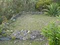 The outline of the original barracks
 -
 One of the few remaining walls
 -
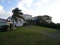 The house which was built over the original fort


See also
External links
- The BVI's formidable forts
- v
- t
- e
British Virgin Islands articles
- Dutch Virgin Islands
- St. Phillip's Church
- Slavery
- Piracy
- Colonial leaders
- United States Virgin Islands
- British Leeward Islands
- West Indies Federation
- Effects of Hurricane Irma

- Anegada
- Beef Island
- Bellamy Cay
- Buck Island
- Carvel Rock
- Cockroach Island
- Cooper Island
- Dead Chest Island
- Diamond Cay
- Dog Islands
- East Seal Dog Island
- Eustatia
- Fallen Jerusalem Island
- Frenchman's Cay
- George Dog Island
- Ginger Island
- Great Camanoe
- Great Dog Island
- Great Thatch
- Great Tobago Island
- Green Cay
- Guana Island
- The Indians
- Jost Van Dyke
- Little Camanoe
- Little Cay
- Little Jost Van Dyke
- Little Thatch
- Little Tobago
- Little Wickams Cay
- Marina Cay
- Mosquito Island
- Nanny Cay
- Necker Island
- Norman Island
- Old Jerusalem Island
- Pelican Island
- Peter Island
- Prickly Pear
- Round Rock
- Saba Rock
- Salt Island
- Sandy Cay
- Sandy Spit
- Scrub Island
- Tortola
- Virgin Gorda
- West Dog Island
- Wickams Cay
|
- Cooper Bay ruin
- Cooten Bay ruin
- Copper Mine
- Fort Burt
- Fort Charlotte
- Fort George
- Fort Purcell ("the Dungeon")
- Fort Recovery
- Great Thatch ruin
- Hunthum's Ghut ruin
- Johnson's Ghut ruin
- Larmer Bay ruin
- Mount Healthy windmill
- Road Town Fort
- St Phillip's Church ("the African Church")
- Trunk Bay ruin
- Whelk Point Fort
- Terrance B. Lettsome International Airport
- Queen Elizabeth II Bridge
- Category
18°25′15″N 64°34′13″W / 18.4207°N 64.5702°W / 18.4207; -64.5702
 | This British Virgin Islands location article is a stub. You can help Wikipedia by expanding it. |
- v
- t
- e


