Washington Pass

48°31.4′N 120°39.3′W / 48.5233°N 120.6550°W / 48.5233; -120.6550
Rainy Pass
Rainy Pass in spring
Elevation4,875 ft (1,486 m)
Traversed byState Route 20
LocationChelan / Skagit counties, Washington, United States
RangeCascades
Coordinates48°31.1′N 120°44.1′W / 48.5183°N 120.7350°W / 48.5183; -120.7350
Washington Pass, North Cascades

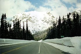
Washington Pass (el. 5477 ft./1669 m.) and Rainy Pass (el. 4875 ft./1486 m.) are two mountain passes on State Route 20 (North Cascades Highway) in the North Cascades mountains of Washington state. Rainy Pass is about 4 miles to the west of Washington Pass. The passes are typically closed between November and April due to heavy snowfall.

The north–south Pacific Crest Trail crosses east-west Highway 20 at Rainy Pass. The Washington Pass Overlook Trail, designated a National Recreation Trail in 1978, runs a short 0.2 miles (0.32 km) from the pass to an overlook with views of Liberty Bell Mountain and the highway 700 feet (210 m) below.[1]

Climate

Washington and Rainy Passes are located in the marine west coast climate zone of western North America.[2] Most weather fronts originate in the Pacific Ocean, and travel northeast toward the Cascade Mountains. As fronts approach the North Cascades, they are forced upward by the peaks of the Cascade Range (Orographic lift), causing them to drop their moisture in the form of rain or snowfall onto the Cascades. As a result, the west side of the North Cascades experiences high precipitation, especially during the winter months in the form of snowfall.[2] During winter months, weather is usually cloudy, but, due to high pressure systems over the Pacific Ocean that intensify during summer months, there is often little or no cloud cover during the summer.[3] Because of maritime influence, snow tends to be wet and heavy, resulting in high avalanche danger.[3] The North Cascades Highway east of Washington Pass has the distinction of being among the top areas in the United States for most avalanche paths per mile of highway.[4]

Climate data for Rainy Pass, Washington, 1991–2020 normals: 4890ft (1490m)
Month Jan Feb Mar Apr May Jun Jul Aug Sep Oct Nov Dec Year
Mean daily maximum °F (°C) 27.7
(−2.4)
30.3
(−0.9)
35.8
(2.1)
43.4
(6.3)
52.3
(11.3)
57.6
(14.2)
68.0
(20.0)
67.2
(19.6)
56.9
(13.8)
42.9
(6.1)
31.8
(−0.1)
26.1
(−3.3)
45.0
(7.2)
Daily mean °F (°C) 23.5
(−4.7)
25.0
(−3.9)
29.3
(−1.5)
35.5
(1.9)
42.9
(6.1)
47.9
(8.8)
56.5
(13.6)
56.5
(13.6)
48.8
(9.3)
37.7
(3.2)
28.0
(−2.2)
22.3
(−5.4)
37.8
(3.2)
Mean daily minimum °F (°C) 19.3
(−7.1)
19.6
(−6.9)
22.7
(−5.2)
27.6
(−2.4)
33.4
(0.8)
38.2
(3.4)
45.0
(7.2)
45.7
(7.6)
40.6
(4.8)
32.4
(0.2)
24.2
(−4.3)
18.5
(−7.5)
30.6
(−0.8)
Average precipitation inches (mm) 8.80
(224)
6.18
(157)
6.33
(161)
3.73
(95)
2.55
(65)
1.95
(50)
1.04
(26)
1.25
(32)
2.31
(59)
5.83
(148)
9.27
(235)
8.21
(209)
57.45
(1,461)
Source 1: XMACIS2[5]
Source 2: NOAA (Precipitation)[6]

References

  1. ^ "Washington Pass Overlook Trail". American Trails. 2013-04-24. Retrieved 2014-08-14.
  2. ^ a b Beckey, Fred W. (2009). Cascade Alpine Guide: climbing and high routes, Vol. 3, Rainy Pass to Fraser River (3rd ed.). Mountaineers Books. p. 302. ISBN 978-1-59485-136-0.
  3. ^ a b Beckey, p. 16
  4. ^ Avalanche Control.wsdot.wa.gov
  5. ^ "xmACIS2". National Oceanic and Atmospheric Administration. Retrieved September 24, 2023.
  6. ^ "Rainy Pass, Washington 1991-2020 Monthly Normals". Retrieved September 26, 2023.

External links

  • U.S. Geological Survey Geographic Names Information System: Washington Pass—Washington Pass
  • U.S. Geological Survey Geographic Names Information System: Rainy Pass—Rainy Pass
  • Pass road conditions from WSDOT
Places adjacent to Washington Pass
Cutthroat Benchmark Hinkhouse Peak Silver Star Mountain
Molar Tooth Snagtooth Ridge
Cutthroat Peak
Washington Pass
Big Kangaroo
Whistler Mountain Wallaby Peak
Rainy Peak Liberty Bell Mountain Copper Benchmark
  • v
  • t
  • e
Former or proposed: SR 237
Authority control databases: National Edit this at Wikidata
  • Israel
  • United States

48°31.4′N 120°39.3′W / 48.5233°N 120.6550°W / 48.5233; -120.6550


Stub icon

This Chelan County, Washington state location article is a stub. You can help Wikipedia by expanding it.

  • v
  • t
  • e