Villeloin-Coulangé
You can help expand this article with text translated from the corresponding article in French. (February 2016) Click [show] for important translation instructions.
- View a machine-translated version of the French article.
- Machine translation, like DeepL or Google Translate, is a useful starting point for translations, but translators must revise errors as necessary and confirm that the translation is accurate, rather than simply copy-pasting machine-translated text into the English Wikipedia.
- Do not translate text that appears unreliable or low-quality. If possible, verify the text with references provided in the foreign-language article.
- You must provide copyright attribution in the edit summary accompanying your translation by providing an interlanguage link to the source of your translation. A model attribution edit summary is
Content in this edit is translated from the existing French Wikipedia article at [[:fr:Villeloin-Coulangé]]; see its history for attribution. - You may also add the template
{{Translated|fr|Villeloin-Coulangé}}to the talk page. - For more guidance, see Wikipedia:Translation.
Commune in Centre-Val de Loire, France
Villeloin-Coulangé | ||
|---|---|---|
Commune | ||
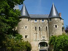
 An aerial view of Villeloin-Coulangé | ||
Location of Villeloin-Coulangé  | ||
(2020–2026) Maryse Garnier[1] | | |
| Area 1 | 34.62 km2 (13.37 sq mi) | |
| Population (2021)[2] | 588 | |
| • Density | 17/km2 (44/sq mi) | |
| Time zone | UTC+01:00 (CET) | |
| • Summer (DST) | UTC+02:00 (CEST) | |
| INSEE/Postal code | 37277 /37460 | |
| Elevation | 92–144 m (302–472 ft) | |
| 1 French Land Register data, which excludes lakes, ponds, glaciers > 1 km2 (0.386 sq mi or 247 acres) and river estuaries. | ||
Villeloin-Coulangé (French pronunciation: [vil.lwɛ̃ kulɑ̃ʒe]) is a commune in the Indre-et-Loire department in central France.
Geography
The Indrois flows northwest through the commune and crosses the village.
Population
| Year | Pop. | ±% p.a. |
|---|---|---|
| 1968 | 830 | — |
| 1975 | 681 | −2.79% |
| 1982 | 573 | −2.44% |
| 1990 | 571 | −0.04% |
| 1999 | 618 | +0.88% |
| 2007 | 638 | +0.40% |
| 2012 | 643 | +0.16% |
| 2017 | 599 | −1.41% |
| Source: INSEE[3] | ||
See also
References
- ^ "Répertoire national des élus: les maires". data.gouv.fr, Plateforme ouverte des données publiques françaises (in French). 2 December 2020.
- ^ "Populations légales 2021". The National Institute of Statistics and Economic Studies. 28 December 2023.
- ^ Population en historique depuis 1968, INSEE
Wikimedia Commons has media related to Villeloin-Coulangé.
- v
- t
- e
Communes of the Indre-et-Loire department 

- Abilly
- Ambillou
- Amboise
- Anché
- Antogny-le-Tillac
- Artannes-sur-Indre
- Assay
- Athée-sur-Cher
- Autrèche
- Auzouer-en-Touraine
- Avoine
- Avon-les-Roches
- Avrillé-les-Ponceaux
- Azay-le-Rideau
- Azay-sur-Cher
- Azay-sur-Indre
- Ballan-Miré
- Barrou
- Beaulieu-lès-Loches
- Beaumont-en-Véron
- Beaumont-Louestault
- Beaumont-Village
- Benais
- Berthenay
- Betz-le-Château
- Bléré
- Bossay-sur-Claise
- Bossée
- Le Boulay
- Bourgueil
- Bournan
- Boussay
- Braslou
- Braye-sous-Faye
- Braye-sur-Maulne
- Brèches
- Bréhémont
- Bridoré
- Brizay
- Bueil-en-Touraine
- Candes-Saint-Martin
- Cangey
- La Celle-Guenand
- La Celle-Saint-Avant
- Céré-la-Ronde
- Cerelles
- Chambon
- Chambourg-sur-Indre
- Chambray-lès-Tours
- Champigny-sur-Veude
- Chançay
- Chanceaux-près-Loches
- Chanceaux-sur-Choisille
- Channay-sur-Lathan
- La Chapelle-aux-Naux
- La Chapelle-Blanche-Saint-Martin
- La Chapelle-sur-Loire
- Charentilly
- Chargé
- Charnizay
- Château-la-Vallière
- Château-Renault
- Chaumussay
- Chaveignes
- Chédigny
- Cheillé
- Chemillé-sur-Dême
- Chemillé-sur-Indrois
- Chenonceaux
- Chezelles
- Chinonsubpr
- Chisseaux
- Chouzé-sur-Loire
- Cigogné
- Cinais
- Cinq-Mars-la-Pile
- Ciran
- Civray-de-Touraine
- Civray-sur-Esves
- Cléré-les-Pins
- Continvoir
- Cormery
- Coteaux-sur-Loire
- Couesmes
- Courçay
- Courcelles-de-Touraine
- Courcoué
- Couziers
- Cravant-les-Côteaux
- Crissay-sur-Manse
- La Croix-en-Touraine
- Crotelles
- Crouzilles
- Cussay
- Dame-Marie-les-Bois
- Descartes
- Dierre
- Dolus-le-Sec
- Draché
- Druye
- Épeigné-les-Bois
- Épeigné-sur-Dême
- Esves-le-Moutier
- Esvres
- Faye-la-Vineuse
- La Ferrière
- Ferrière-Larçon
- Ferrière-sur-Beaulieu
- Fondettes
- Francueil
- Genillé
- Gizeux
- Le Grand-Pressigny
- La Guerche
- Les Hermites
- Hommes
- Huismes
- L'Île-Bouchard
- Jaulnay
- Joué-lès-Tours
- Langeais
- Larçay
- Lémeré
- Lerné
- Le Liège
- Lignières-de-Touraine
- Ligré
- Ligueil
- Limeray
- Lochessubpr
- Loché-sur-Indrois
- Louans
- Le Louroux
- Lublé
- Lussault-sur-Loire
- Luynes
- Luzé
- Luzillé
- Maillé
- Manthelan
- Marçay
- Marcé-sur-Esves
- Marcilly-sur-Maulne
- Marcilly-sur-Vienne
- Marigny-Marmande
- Marray
- Mazières-de-Touraine
- La Membrolle-sur-Choisille
- Mettray
- Monnaie
- Montbazon
- Monthodon
- Montlouis-sur-Loire
- Montrésor
- Montreuil-en-Touraine
- Monts
- Morand
- Mosnes
- Mouzay
- Nazelles-Négron
- Neuil
- Neuillé-le-Lierre
- Neuillé-Pont-Pierre
- Neuilly-le-Brignon
- Neuville-sur-Brenne
- Neuvy-le-Roi
- Noizay
- Notre-Dame-d'Oé
- Nouans-les-Fontaines
- Nouâtre
- Nouzilly
- Noyant-de-Touraine
- Orbigny
- Panzoult
- Parçay-Meslay
- Parçay-sur-Vienne
- Paulmy
- Pernay
- Perrusson
- Le Petit-Pressigny
- Pocé-sur-Cisse
- Pont-de-Ruan
- Ports-sur-Vienne
- Pouzay
- Preuilly-sur-Claise
- Pussigny
- Razines
- Reignac-sur-Indre
- Restigné
- Reugny
- La Riche
- Richelieu
- Rigny-Ussé
- Rillé
- Rilly-sur-Vienne
- Rivarennes
- Rivière
- La Roche-Clermault
- Rochecorbon
- Rouziers-de-Touraine
- Saché
- Saint-Antoine-du-Rocher
- Saint-Aubin-le-Dépeint
- Saint-Avertin
- Saint-Benoît-la-Forêt
- Saint-Branchs
- Saint-Christophe-sur-le-Nais
- Saint-Cyr-sur-Loire
- Sainte-Catherine-de-Fierbois
- Sainte-Maure-de-Touraine
- Saint-Épain
- Saint-Étienne-de-Chigny
- Saint-Flovier
- Saint-Genouph
- Saint-Germain-sur-Vienne
- Saint-Hippolyte
- Saint-Jean-Saint-Germain
- Saint-Laurent-de-Lin
- Saint-Laurent-en-Gâtines
- Saint-Martin-le-Beau
- Saint-Nicolas-de-Bourgueil
- Saint-Nicolas-des-Motets
- Saint-Ouen-les-Vignes
- Saint-Paterne-Racan
- Saint-Pierre-des-Corps
- Saint-Quentin-sur-Indrois
- Saint-Règle
- Saint-Roch
- Saint-Senoch
- Saunay
- Savigné-sur-Lathan
- Savigny-en-Véron
- Savonnières
- Sazilly
- Semblançay
- Sennevières
- Sepmes
- Seuilly
- Sonzay
- Sorigny
- Souvigné
- Souvigny-de-Touraine
- Sublaines
- Tauxigny-Saint-Bauld
- Tavant
- Theneuil
- Thilouze
- Thizay
- Tournon-Saint-Pierre
- Tourspref
- La Tour-Saint-Gelin
- Trogues
- Truyes
- Vallères
- Varennes
- Veigné
- Véretz
- Verneuil-le-Château
- Verneuil-sur-Indre
- Vernou-sur-Brenne
- Villaines-les-Rochers
- Villandry
- La Ville-aux-Dames
- Villebourg
- Villedômain
- Villedômer
- Villeloin-Coulangé
- Villeperdue
- Villiers-au-Bouin
- Vou
- Vouvray
- Yzeures-sur-Creuse
- pref: prefecture
- subpr: subprefecture
| Authority control databases: National |
|
|---|
 | This Indre-et-Loire geographical article is a stub. You can help Wikipedia by expanding it. |
- v
- t
- e


