Valdez, New Mexico
Unincorporated community in New Mexico, United States
36°32′04″N 105°35′02″W / 36.53444°N 105.58389°W / 36.53444; -105.5838987580[1]
Valdez is an unincorporated community located in Taos County, New Mexico, United States situated along the Rio Hondo. The community is located on New Mexico State Road 230, 8.8 miles (14.2 km) north of Taos. Valdez had a post office until August 28, 2010; it still has its own ZIP code, 87580.[1][3]
Gallery
-
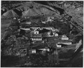 View of Valdez in 1941. Note layout of houses in plaza around the church, a style that is common to all of the oldest villages.
 -
 View of Valdez on 19 May 2023.


References
- ^ a b United States Postal Service. "USPS - Look Up a ZIP Code". Retrieved November 29, 2014.
- ^ "Valdez". Geographic Names Information System. United States Geological Survey, United States Department of the Interior.
- ^ "Postmaster Finder - Post Offices by ZIP Code". United States Postal Service. Retrieved November 29, 2014.
left
- v
- t
- e
Municipalities and communities of Taos County, New Mexico, United States
County seat: Taos

communities
‡This populated place also has portions in an adjacent county or counties
- New Mexico portal
- United States portal
 | This New Mexico state location article is a stub. You can help Wikipedia by expanding it. |
- v
- t
- e


