Upper Svratka Highlands
You can help expand this article with text translated from the corresponding article in Czech. (March 2024) Click [show] for important translation instructions.
- Machine translation, like DeepL or Google Translate, is a useful starting point for translations, but translators must revise errors as necessary and confirm that the translation is accurate, rather than simply copy-pasting machine-translated text into the English Wikipedia.
- Do not translate text that appears unreliable or low-quality. If possible, verify the text with references provided in the foreign-language article.
- You must provide copyright attribution in the edit summary accompanying your translation by providing an interlanguage link to the source of your translation. A model attribution edit summary is
Content in this edit is translated from the existing Czech Wikipedia article at [[:cs:Hornosvratecká vrchovina]]; see its history for attribution. - You may also add the template
{{Translated|cs|Hornosvratecká vrchovina}}to the talk page. - For more guidance, see Wikipedia:Translation.


Hornosvratecká vrchovina CZ I2C-4.png

The Upper Svratka Highlands (Czech: Hornosvratecká vrchovina, German: Hohe Schwarza Bergeland) is a mountain range in Moravia, Czech Republic. The Highlands, together with the Křižanov Highlands threshold, form the Western-Moravian part of Moldanubian Zone – east south part of Bohemian Massif.[1]
Geography
The Upper Svratka Highlands rise to the north of the Tišnov, Moravia between Lomnice u Tišnova, and the Svratka in the north. The Highlands have an area of 1,135 square kilometres (438 sq mi) and an average height of 580 metres (1,900 ft). The highest peak is Devět skal at 836 metres (2,743 ft); other peaks are Žákova hora 810 metres (2,660 ft) Pohledecká skála 800 metres (2,600 ft), Horní les 774 metres (2,539 ft), Harusův kopec 741 metres (2,431 ft), Přední skála 712 metres (2,336 ft), or Sýkoř 702 metres (2,303 ft).
The northwestern part is formed by Žďárské vrchy mountain range. To the southeast is the Boskovice Furrow in the mid-Moravian part of the Brno Highlands as well and in the east the Svitavy Uplands. The Svratka river stream naturally established Bohemian-Moravian border, the other part of Elbe–Danube main European watershed
The mountain range is 63% forested, though mainly by plantations - spruces, maples, beeches, elmeses. The forests are in well condition.
The primary composition of the range is cretaceous granite, migmatite, orthogneiss, amphibole, granodiorite, gabbro and quartz slate. Often gneis. Soil horizon – mainly cambisol.[2]
The rivers Svratka, Bystřice [cs], Loučka [cs], Nedvědička [cs] among others, originate here.
Population
The area is relatively sparsely populated (in terms of the Czech Republic). The largest towns in the Upper Svratka Highlands are Nové Město na Moravě (partly), Bystřice nad Pernštejnem, Kunštát, Olešnice and Bystré.
Gallery
-
 View across the Vír Reservoir
 -
 Devět skal rock
 -

-
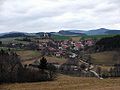
 Lomnice u Tišnova - the most southern part of Upper Svratka Highlands
 -
 Mausoleum of the Pernštejn family in Doubravník
 -
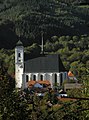
 Lomnice
 -
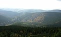
 Vítochov surrounding
 -
 Svratka surrounding


References
Further reading
- Geografický místopisný slovník, Academia, Praha, 1993. ISBN 80-200-0445-9
Wikimedia Commons has media related to Hornosvratecká vrchovina.
- v
- t
- e
 Mountain ranges of the Czech Republic
- Bohemian Forest
- Brdy
- Central Bohemian Uplands
- Doupov Mountains
- Elbe Sandstone Mountains
- Fichtel Mountains
- Giant Mountains
- Hostýn-Vsetín Mountains
- Hrubý Jeseník
- Javořice Highlands
- Ještěd–Kozákov Ridge
- Jizera Mountains
- Lusatian Mountains
- Maple Mountains
- Moravian-Silesian Beskids
- Ore Mountains
- Upper Palatinate Forest
- White Carpathians
| Authority control databases: National |
|
|---|


