Tupã, São Paulo
Municipality in Southeast, Brazil

Flag

Coat of arms
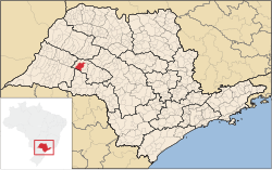
Location in São Paulo
 Brazil
 São Paulo
 (2020)[1]
Tupã is a municipality in the state of São Paulo in Brazil. The population is 65,570 (2020 est.) in an area of 628 km2.[3] The city is located in the Alta Paulista Region and it is located 530 km (329.32 sq mi) from capital São Paulo. It was founded on October 12, 1929 by Luiz de Souza Leão a business man that chose the region that were tropical forest. The city is located between 2 rivers: Aguapeí River and Rio do Peixe.
The city is named after a god of thunder in the Guaraní mythology.[citation needed]
Media
In telecommunications, the city was served by Telecomunicações de São Paulo.[4] In July 1998, this company was acquired by Telefónica, which adopted the Vivo brand in 2012. The company is currently an operator of cell phones, fixed lines, internet (fiber optics/4G) and television (satellite and cable).[5]
References
- ^ IBGE 2020
- ^ "Archived copy" (PDF). United Nations Development Programme (UNDP). Archived from the original (PDF) on July 8, 2014. Retrieved August 1, 2013.
{{cite web}}: CS1 maint: archived copy as title (link) - ^ "IBGE - Instituto Brasileiro de Geografia e Estatística". Retrieved 9 August 2016.
- ^ "Creation of Telesp - April 12, 1973". www.imprensaoficial.com.br (in Portuguese). Retrieved 2024-06-14.
- ^ "Our History - Telefônica RI". Telefônica. Retrieved 2024-06-14.
External links
- (in Portuguese) Tupã City Hall Website
- (in Portuguese) Tourism Information (provided by the City Hall)
- (in Portuguese) Satellite image of Tupã on Google Maps
- v
- t
- e
Capital: São Paulo
Araçatuba | |||||||
|---|---|---|---|---|---|---|---|
| |||||||

Araraquara | |||||
|---|---|---|---|---|---|
| |||||
Assis | |||||
|---|---|---|---|---|---|
| |||||
Bauru | |||||||||||
|---|---|---|---|---|---|---|---|---|---|---|---|
| |||||||||||
Campinas | |||||||||||
|---|---|---|---|---|---|---|---|---|---|---|---|
| |||||||||||
Itapetininga | |||||||||
|---|---|---|---|---|---|---|---|---|---|
| |||||||||
Litoral Sul Paulista | |||||
|---|---|---|---|---|---|
| |||||
Macro Metropolitana Paulista | |||||||||
|---|---|---|---|---|---|---|---|---|---|
| |||||||||
Marília | |||||
|---|---|---|---|---|---|
| |||||
Metropolitana de São Paulo | |||||||||||||||
|---|---|---|---|---|---|---|---|---|---|---|---|---|---|---|---|
| |||||||||||||||
Piracicaba | |||||||
|---|---|---|---|---|---|---|---|
| |||||||
Presidente Prudente | |
|---|---|
Ribeirão Preto | |||||||||||||||
|---|---|---|---|---|---|---|---|---|---|---|---|---|---|---|---|
| |||||||||||||||
São José do Rio Preto | |||||||||||||||||
|---|---|---|---|---|---|---|---|---|---|---|---|---|---|---|---|---|---|
| |||||||||||||||||
Vale do Paraíba Paulista | |||||||||||||
|---|---|---|---|---|---|---|---|---|---|---|---|---|---|
| |||||||||||||
Authority control databases | |
|---|---|
| International |
|
| National |
|
 | This geographical article relating to the state of São Paulo is a stub. You can help Wikipedia by expanding it. |
- v
- t
- e


