Tower Hill State Park

State Park in Iowa County, Wisconsin and United States Historic Place

43°8′48″N 90°2′55″W / 43.14667°N 90.04861°W / 43.14667; -90.04861Area77 acres (31 ha)Established1922Governing bodyWisconsin Department of Natural Resources
United States historic place
Shot Tower
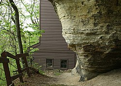
The base of the shot tower, where the shaft starts
Tower Hill State Park is located in Wisconsin
Tower Hill State Park
Show map of Wisconsin
Tower Hill State Park is located in the United States
Tower Hill State Park
Show map of the United States
LocationSE of Spring Green in Tower Hill State Park
Built1831–1833
NRHP reference No.73000080
Added to NRHPApril 3, 1973

Tower Hill State Park is a state park of Wisconsin, United States, which contains the reconstructed Helena Shot Tower. The original shot tower was completed in 1832 and manufactured lead shot until 1860. It was added to the National Register of Historic Places in 1973.[1][2] The park abuts the Wisconsin River and is bordered by state-owned land comprising the Lower Wisconsin State Riverway.

Natural history

The bluffs along the Wisconsin River are formed of Jordan Sandstone. The park lies within the Driftless Area, a region of the American Midwest that remained ice-free through three successive ice ages.[3] In the 19th century the Wisconsin River flowed directly past the base of the bluffs. The river has since shifted slightly, and a stream known as Mill Creek marks the northern boundary of the park.

History of the shot tower

Shot towers harness the effects of surface tension on liquids in free-fall, a technique developed in 1782. Molten lead can be poured through a strainer at the top of a tower or shaft. The droplets become spherical as they fall and cool in this shape during their descent. The pellets are caught in a water basin to break their fall and finish cooling.

In 1830 a businessman from Green Bay, Wisconsin, named Daniel Whitney was traveling along the Wisconsin River and recognized a sharp bluff near the town of Helena as a promising location for a shot tower. Lead deposits had recently been discovered in several locations around Iowa County. From the top of the bluff there was a 60-foot (18 m) sheer drop, below which the sandstone cliff sloped down to the riverbank, 180 feet (55 m) below the clifftop. Whitney formed the Wisconsin Shot Company with some other investors, and set his employee John Metcalf to oversee construction.[4]

The 60-foot (18 m) cliff was a convenient headstart, but Metcalf needed someone to continue a shaft for the remaining 120 feet (37 m) to ground level. Access to the bottom of the shaft, where the lead shot would be collected, necessitated a 90-foot (27 m) horizontal tunnel. In 1831 Thomas B. Shaunce, a 22-year-old lead miner in Galena, Illinois, was hired for the task.

Shaunce worked mostly alone but received some assistance from a friend named Malcom Smith. They dug with pickaxes and a gad, using gunpowder to loosen the harder rock of the lower layers. Shaunce used a plumb-bob to ensure that he was keeping the shaft perfectly straight, and a windlass to haul out the broken rock. Shaunce calculated where to begin digging the horizontal tunnel by standing across the water and sighting with his rifle directly below the top of the shaft. He dug in from the riverbank, using a line of stakes to maintain his alignment. When he first broke through from the horizontal tunnel to the bottom of the shaft, a blast of air knocked Shaunce unconscious and collapsed one of his lungs.[5]

The project took 187 working days, interrupted in the spring of 1832 when Shaunce and Smith both returned to Galena and enlisted in the Illinois Militia to fight in the Black Hawk War. Shaunce had been contracted to be paid $1000 for his work, but was ultimately offered land instead.[5]

A smelting house was built at the top of the cliff, and the 60-foot (18 m) drop from there to the opening of Shaunce's tunnel was enclosed with a wooden shaft. A finishing house was built on the riverbank, where the shot was dried, graded, and sorted. This was joined by a warehouse and docks.[6] In 1836 Whitney sold the property to a group of businessmen from New York for $10,000.[7] Later Cadwallader C. Washburn and a business partner purchased the site.[4] In 1852 they replaced the finishing house and installed steam-operated equipment, nearly doubling the operation's productivity.[7] The shot tower was operated by a crew of six, producing between 600 and 800 pounds of quality shot per day. Miscast pieces were melted and reused. The finished shot, graded by size, was transported to Milwaukee and then shipped east.[3]

Operations ceased in 1860 during an economic downturn, and the buildings and equipment were sold away. The village of Helena was abandoned soon after. Thomas Shaunce died around 1860 as well. Throughout his life he experienced respiratory trouble from the air blast in the tunnel, and felt he had been cheated of his proper payment.[5]

Historians have noted that the Helena Shot Tower, which allowed a frontier resource to be shipped in a finished form, was significant in the settlement and prosperity of southwestern Wisconsin.[4][6] The overland teamster route developed to transport the operation's output to the east evolved into a road and then a rail line. Returning wagon teams brought supplies and immigrants.[7] Southwestern Wisconsin, once more closely tied to the Southern United States via the Mississippi River, built a population and culture closer to the northeast.[4]

Later history

Log gazebo remaining from the Tower Hill Pleasure Company

In 1889 the site was purchased for $60 by the prominent Unitarian minister Jenkin Lloyd Jones, a member of a well-known Welsh-American family in the region. He created a recreational and educational retreat called the Tower Hill Pleasure Company, which provided outdoor recreation, visiting lecturers, books, and music. The retreat grew to include 25 cottages, as well as a dining pavilion, tennis courts, and other structures. One 1894 lecturer, a history professor, spent his free time excavating the shot tower's shaft and recovered several pieces of equipment which Lloyd Jones donated to the Wisconsin Historical Society.[4] In 1911 Jones' nephew Frank Lloyd Wright began building his studio Taliesin on a neighboring hill.

After Lloyd Jones died in 1918 his wife Edith donated the site to the state, and Tower Hill State Park was officially created in 1922. The smelting house and wooden shaft were rebuilt between 1970 and 1971 by the Wisconsin Department of Natural Resources and the Wisconsin Historical Society.[8]

In 2006 parts of a horror film called Witches' Night were filmed within the state park.[9]

Recreation

Tower Hill State Park is open from May to October. Visitors can enter several historical structures. The smelting house contains exhibits about the construction and use of the shot tower. Structures remaining from the Tower Hill Pleasure Company include the pavilion (now the park's picnic shelter), a gazebo, and the foundation of a barn. There are two miles (3 km) of trails leading up to the tower and down to the riverbank, where visitors can enter the horizontal tunnel to the bottom of the shaft. There is a small campground with 15 campsites, drinking water, and pit toilets. Nearby attractions include Taliesin, the American Players Theatre, the House on the Rock, and Governor Dodge State Park.

References

  1. ^ "Shot Tower". Wisconsin Historical Society. Retrieved January 15, 2013.
  2. ^ Anderson, Donald N. (July 24, 1972). "Shot Tower". NRHP Inventory-Nomination Form. National Park Service. Retrieved October 30, 2016.
  3. ^ a b "Tower Hill State Park Visitor". Wisconsin Department of Natural Resources. 2006. {{cite journal}}: Cite journal requires |journal= (help)
  4. ^ a b c d e Folkedahl, Beulah (Summer 1959). "Forgotten Villages: Helena". Wisconsin Magazine of History. 42 (4): 288–92.
  5. ^ a b c Wisconsin Department of Natural Resources. Tower Hill State Park interpretive signage.
  6. ^ a b Titus, W.A. (March 1928). "Historic Spots in Wisconsin: The Helena Shot-Tower". Wisconsin Magazine of History. 11 (3): 320–7.
  7. ^ a b c Stark, William F. (1988). Wisconsin, River of History.
  8. ^ Bogue, Margaret Beattie (1990). "Exploring Wisconsin's Waterways". Madison, Wis.: Legislative Reference Bureau.
  9. ^ Conklin, Melanie (May 14, 2000). "Movie crew films bewitching horror in Spring Green". Wisconsin State Journal. Madison, Wis. pp. 015.H.

External links

Wikimedia Commons has media related to Tower Hill State Park.
  • Tower Hill State Park
  • v
  • t
  • e
Federal
National Park Service
National Forests
National Wildlife Refuges
National Trails
National Estuarine Research Reserves
National Marine Sanctuaries
National Wild and Scenic Rivers
  • St. Croix River
  • Wolf River
National Wilderness Preservation System
State
State Parks
State Natural Areas
  • Ableman's Gorge
  • Abraham's Woods
  • Adiantum Woods
  • Albany Sand Prairie & Oak Savanna
  • Allen Creek Wetlands
  • Allequash Lake
  • Alvin Creek Headwaters
  • Ancient Aztalan Village
  • Anvil Lake Trail
  • Apostle Islands Critical Species
  • Apostle Islands Maritime Cliffs
  • Apostle Islands Maritime Forest
  • Apostle Islands Sandscape
  • Apostle Islands Yew Forest
  • Apple River Canyon
  • Arbutus Oaks
  • Arena Pines and Sand Barrens
  • Argonne Experimental Forest
  • Atkins Lake & Hiles Swamp
  • Audubon Goose Pond
  • Aurora Lake
  • Avoca River-Bottom Prairie
  • Avon Bottoms
  • Badfish Creek Wet Prairie & Spring Seeps
  • Baileys Harbor Boreal Forest and Wetlands
  • Bakken's Pond
  • Baraboo River Floodplain Forest
  • Bark Bay Slough
  • Barksdale Ponds
  • Barneveld Prairie
  • Barney Creek
  • Bass Hollow
  • Bass Lake Fen
  • Bass Lake Peatlands
  • Bass Lake Preserve
  • Bastile Lake
  • Battle Bluff Prairie
  • Battle Creek Hemlocks
  • Bauer-Brockway Barrens
  • Baxter's Hollow
  • Bay City Mine
  • Bayshore Blufflands
  • Bean Lake
  • Bear Beach
  • Bear Bluff
  • Bear Caves
  • Bear Creek Cave
  • Bear Creek Hemlocks
  • Bear Creek Sedge Meadow
  • Bear Lake Sedge Meadow
  • Bear Lake Slough
  • Bearsdale Creek & Hyatt Springs
  • Beaver Brook
  • Beaver Creek
  • Belden Swamp
  • Belmont Mound
  • Belmont Prairie
  • Berg Prairie and Billy Goat Ridge
  • Bergen Bluffs
  • Berlin Fen
  • Beulah Bog
  • Bibon Swamp
  • Big and Little Marsh
  • Big Bay Sand Spit and Bog
  • Big Beaver Meadow
  • Big Eau Pleine Woods
  • Big Island
  • Big Manitou Falls
  • Big Rock Pines
  • Big Swamp
  • Big Swamp Tamarack Fen
  • Bittersweet Lakes
  • Black Creek Bog
  • Black Earth Rettenmund Prairie
  • Black Lake Bog
  • Black River Savanna
  • Black Tern Bog
  • Blackhawk Island
  • Blackjack Springs
  • Bloch Oxbow
  • Blomberg Lake
  • Blue Hills Felsenmeer
  • Blue River Bluffs
  • Blue River Sand Barrens
  • Blue Swamp
  • Blueberry Swamp
  • Blueberry Trail
  • Bluff Creek
  • Bogus Swamp
  • Bohn Lake
  • Bonita Country
  • Borah Creek Prairie
  • Border Lakes
  • Borst Valley Sedge Meadow
  • Boscobel Bluffs
  • Bradley Creek Swamp Conifers
  • Brady's Bluff Prairie
  • Brant Brook Pines
  • Brockway Ponds
  • Brooks Bluff
  • Browntown Oak Forest
  • Brule Glacial Spillway
  • Brule River Boreal Forest
  • Brule River Cliffs
  • Brule Rush Lake
  • Brunsweiler River and Mineral Lake
  • Brush Creek Hemlocks
  • Buckhorn Barrens
  • Buena Vista Prairie Chicken Meadow
  • Buena Vista Quarry Prairie
  • Buffalo River Trail Prairies
  • Butler Lake and Flynn's Spring
  • Cady's Marsh
  • Camp Five Lake
  • Camp Lake and Pines
  • Camp Nine Pines
  • Camp Three Lake
  • Canoe Landing Prairie
  • Caroline Lake
  • Carver-Roehl Woods
  • Caryville Savanna
  • Cassville Bluffs
  • Castle Mound Pine Forest
  • Catfish Eddy Terraces
  • Cathedral Pines
  • Catherine Lake Hemlock-Hardwoods
  • Cave Point-Clay Banks
  • Cedar Grove Hawk Research Station
  • Cedarburg Beech Woods
  • Cedarburg Bog
  • Centennial Bedrock Glade
  • Charles Pond
  • Chequamegon Hardwoods
  • Cherney Maribel Caves
  • Cherokee Marsh
  • Cherry Lake Sedge Meadow
  • Chimney Rock Oak Opening
  • Chippewa Moraine Lakes
  • Chippewa Trail
  • Chiwaukee Prairie
  • Chub and Mud Lake Riverine Marsh
  • Chub Lake Oak Savanna
  • Clifford Messinger Dry Prairie & Savanna Preserve
  • Clover Valley Fen
  • Coffee Swamp
  • Comstock Bog-Meadow
  • Coon Creek Cliffs
  • Coon Fork Barrens
  • Copper Falls
  • County Line Barrens and Forest
  • Cranberry Creek Mound Group
  • Crandon Ribbed Fen
  • Crex Sand Prairie
  • Crooked Lake Wetlands
  • Cudahy Woods
  • Cylon
  • Dalles of the St. Croix River
  • Day Lake
  • Deansville Fen
  • Deer Creek Tamarack Bog
  • Deer Fly Swamp
  • Deer Island
  • Deer Mountain
  • Dells of the Eau Claire River
  • Dells of the Wisconsin River
  • Detroit Harbor
  • Devil's Backbone
  • Devil's Lake Oak Forest
  • Devine Lake & Mishonagon Creek
  • Dewey Heights Prairie
  • Dewey Marsh
  • Diamond Lake
  • Diamond Roof
  • Doering Woods
  • Dorothy Lake
  • Dory's Bog and Hunt Hill
  • Drummond Woods
  • Dry Lake
  • Dunbar Barrens
  • Dunn Lake
  • Dunnville Barrens
  • Dupage Lake Peatlands
  • Durst Rockshelter
  • Dwight's Point and Pokegama Wetlands
  • Eagle Centre Prairie
  • Eagle Eye
  • Eagle Oak Opening
  • East Bluff
  • East Fork Chippewa River
  • East Fork of the Black River
  • Echo Lake
  • Eighteen Mile Creek
  • Ekdall Wetlands
  • Elk River Valley
  • Ellison Bluff
  • Emmons Creek Barrens
  • Empire Prairies
  • Empire Swamp
  • English Lake Hemlocks
  • Enterprise Hemlocks
  • Ericson Creek Forest and Wetlands
  • Eureka Maple Woods
  • Europe Bay Woods
  • Fair Meadows
  • Fairy Chasm
  • Fairyland
  • Farmington Bottoms
  • Faville Prairie
  • Fern Dell Gorge
  • Ferry Bluff
  • Finnerud Pine Forest
  • Fish Lake Meadow
  • Fish Lake Pines
  • Five Mile Barrens
  • Five-Mile Bluff Prairie
  • Flambeau River Hardwood Forest
  • Flambeau Wetlands
  • Flat Lake
  • Flora Spring Pond
  • Flume Creek Cedars
  • Forbes Springs
  • Fort McCoy
  • Foulds Creek
  • Fountain Creek Wet Prairie
  • Fourmile Island Rookery
  • Fox Maple Woods
  • Franklin and Butternut Lakes
  • Franklin Savanna
  • French Creek Fen
  • French Creek North
  • Frog Lake and Pines
  • Gasner Hollow Prairie
  • Genesse Oak Opening and Fen
  • Germain Hemlocks
  • Germania Wet Prairie
  • Ghost Lake
  • Giant White Pine Grove
  • Gibraltar Rock
  • Glenn Creek Barrens
  • Glocke Lake
  • Gobler Lake
  • Goose Lake
  • Goose Lake Drumlins
  • Gotham Jack Pine Barrens
  • Grand Island
  • Grandma Lake
  • Grassy Lake
  • Great River Trail Prairies
  • Hagar Mountain
  • Haley Creek Swamp
  • Half Moon Bottoms
  • Hanson Lake Wetlands
  • Hardscrabble Prairie
  • Haskell Noyes Memorial Woods
  • Hawkins Hemlock-Hardwood Forest
  • Hawkinson Creek Wet Prairie
  • Haymeadow Creek
  • Haymeadow Flowage
  • Headwater Lakes
  • Hedmark Pines
  • Hemlock Draw
  • High Cliff Escarpment
  • Highway K Woods
  • Hiles Wetlands
  • Hog Island Tamaracks
  • Hogback Prairie
  • Holland Red Maple Swamp
  • Holland Sand Prairie
  • Holmboe Conifer Forest
  • Honey Creek
  • Hook Lake Bog
  • Hortonville Bog
  • Houghton Falls
  • Hub City Bog
  • Huiras Lake
  • Hulburt Creek Woods
  • Hunting River Alders
  • Inch Lake
  • Interstate Lowland Forest
  • Ipswich Prairie
  • Island Lake Hemlocks
  • Jackson Creek Woods
  • Jackson Harbor Ridges
  • Jackson Marsh
  • Jay Creek Pine Forest
  • Jean Brunet Woods
  • Jefferson Tamarack Swamp
  • Johnson Falls
  • Johnson Hill Kame
  • Johnson Lake Barrens
  • Jones Lake
  • Jump River Woods
  • Jung Hemlock-Beech Forest
  • Kamrath Creek Forest and Fen
  • Kangaroo Lake
  • Karcher Springs
  • Karner Blue Meadow
  • Keller Whitcomb Creek Woods
  • Kelly Lake Hemlocks
  • Kelly Lynn Bog
  • Kentuck Lake
  • Kessler Railroad Prairie
  • Ketchum Creek Pines
  • Kettle Hole Woods
  • Kettle Moraine Low Prairie
  • Kettle Moraine Oak Opening
  • Kettle Moraine Red Oaks
  • Kewaskum Maple-Oak Woods
  • Kickapoo Valley Reserve
  • Kickapoo Wild Woods
  • Kidrick Swamp
  • Kieper Creek
  • Kingston Pines
  • Kinnickinnic River Gorge and Delta
  • Kinnickinnic Wet Prairie
  • Kirby Lake Hardwoods
  • Kissick Alkaline Bog Lake
  • Kohler Park Dunes
  • Kohler-Peet Barrens
  • Koro Prairie
  • Koshkonong Corners
  • Kroenke Lake
  • Krueger Pines
  • Kurtz Woods
  • La Crosse River Trail Prairie
  • LaFave Swamp
  • Lake Alva Birch-Hemlock
  • Lake Evelyn
  • Lake Helane
  • Lake Lackawanna
  • Lake Laura Hardwoods
  • Lake Noquebay Sedge Meadow
  • Lake of the Pines Conifer-Hardwoods
  • Lake Owen Hardwoods
  • Lake Two Pines
  • Lampson Moraine Pines
  • LaSage Bottoms
  • Lauterman Lake
  • Lawin Sedge Meadow
  • Lawrence Creek
  • Lawrence Lake
  • Lawrence Prairie
  • Lawrence Lake
  • Lemonweir Bottomland Hardwood Forest
  • Lily Lake
  • Lima Bog
  • Limery Ridge Savanna
  • Little Bear Hemlocks
  • Little Lake
  • Little Willow Drumlin
  • Little Wolf River
  • Lodde's Mill Bluff
  • Lodi Marsh
  • Logan Creek
  • Loon Lake Woods
  • Lost Canoe
  • Lost Creek Bog
  • Lost Lake
  • Lost Lake Esker
  • Lower Chippewa River
  • Lower Narrows
  • Lower Tomahawk River Pines
  • LTC Old Growth Forest
  • Lulu Lake
  • Lunch Creek Wetlands
  • Magnolia Bluff
  • Maiden Rock Bluff
  • Marinette County Beech Forest
  • Marsh Miller Cedars
  • Marshall's Point
  • Martin's Woods
  • Mary Lake
  • Mayville Ledge Beech-Maple Woods
  • Mazomanie Bottoms
  • Mazomanie Oak Barrens
  • McCarthy Lake and Cedars
  • McCaslin Mountain
  • McGilvra Woods
  • Mead Conifer Bogs
  • Meadow Valley Barrens
  • Mecan River Pine-Oak Forest
  • Mecan Springs
  • Memorial Grove Hemlocks
  • Meridian Park
  • Midway Railroad Prairie
  • Mill Bluff
  • Millston Sand Barrens
  • Millville Oak Woodlands
  • Milwaukee River and Swamp
  • Milwaukee River Floodplain Forest
  • Milwaukee River Tamarack Lowlands and Dundee Kame
  • Minito Lake
  • Mink River
  • Mirror Lake Pine Oak Forest
  • Miscauno Cedar Swamp
  • Mondeaux Hardwoods
  • Moonlight Bay Bedrock Beach
  • Moose Lake
  • Moose River Cedar Hills
  • Moquah Barrens
  • Morgan Coulee Prairie
  • Motts Ravine
  • Mount Pisgah Hemlock-Hardwoods
  • Mountain Lake
  • Mud Lake
  • Mud Lake - Radley Creek Savanna
  • Mud Lake Bog
  • Mud Lake Fen and Wet Prairie
  • Mud Lake Forest and Ponds
  • Muddy Creek Sedge Meadow
  • Muehl Springs
  • Muir Park
  • Mukwa Bottomland Forest
  • Mukwonago River
  • Mullet Creek White Cedar Wetland
  • Muralt Bluff Prairie
  • Muskego Park Hardwoods
  • Myklebust Lake
  • Namekagon Barrens
  • Namekagon Fen
  • Natural Bridge and Rockshelter
  • Navarino Cedar Swamp
  • Navarino Sedge Meadow
  • Necedah Oak-Pine Forest
  • Necedah Oak-Pine Savanna
  • Neda Mine
  • Nell Lake
  • Nelligan Lake
  • Nelson-Trevino Bottoms
  • Nemadji River Floodplain Forest
  • New Auburn Sedge Meadow
  • New Hope Pines
  • New Munster Bog Island
  • New Observatory Woods
  • Newark Road Prairie
  • Newport Conifer-Hardwoods
  • Nichols Creek Cedars and Springs
  • Nichols Creek East Cedars
  • Nine Mile Island
  • Nipissing Swamp
  • Nixon Lake
  • No Name Lake
  • North Bay
  • North Bend Wet Prairie
  • North Branch Bottoms
  • North Country Trail Hardwoods
  • North Fork Eau Claire River
  • North Fork Pines
  • North of North Shattuck Lake
  • North Otter Creek
  • North Pikes Creek Boreal Forest
  • North Pikes Creek Boreal Forest
  • Northeast Lake
  • Norway Point Bottomlands
  • Nourse Sugarbush
  • Oakfield Ledge
  • Oakfield Railroad Prairie
  • Observatory Hill
  • Ohmart Wetlands
  • Oliver Prairie
  • Olson Oak Woods
  • One Stone Lake Hemlocks
  • Orion Mussel Bed
  • Osceola Bedrock Glades
  • Oshkosh-Larsen Trail Prairies
  • Ottawa Lake Fen
  • Otter Creek Oak Barrens
  • Owl Creek Fen Savanna
  • Oxbo Pines
  • Oxbow Rapids
  • Page Creek Marsh
  • Pan Hollow
  • Papoose Creek Pines
  • Parfrey's Glen
  • Parrish Oak Savanna
  • Pat Shay Lake
  • Patterson Hemlocks
  • Pea Creek Sedge Meadow
  • Peat Lake
  • Pecatonica River Woods
  • Peninsula Niagara Escarpment
  • Peninsula Park Beech Forest
  • Peninsula Park White Cedar Forest
  • Perkinstown Hemlocks
  • Peshtigo Brook Meadow & Woods
  • Peshtigo Harbor Lacustrine Forest
  • Peshtigo River Delta Marshes
  • Pewit's Nest
  • Pickerel Lake
  • Pickerel Lake Fen
  • Pine Cliff
  • Pine Hollow
  • Pine Island Savanna
  • Pirus Road Swamp
  • Plagge Woods
  • Plainfield Tunnel Channel Lakes
  • Pleasant Valley Conservancy
  • Plover River Woods
  • Plum Creek Woods
  • Plum Lake Hemlock Forest
  • Point Beach Ridges
  • Pokegama Carnegie Wetlands
  • Pope Lake
  • Popple River Corridor
  • Poppy's Rock
  • Port Wing Boreal Forest
  • Portland Maples
  • Powers Bluff Maple Woods
  • Priest Rock
  • Princeton Prairie
  • Puchyan Prairie
  • Putnam Park
  • Quincy Bluff and Wetlands
  • Rainbow Wetlands
  • Rat Lake Swamp and Popple River Headwaters
  • Red Banks Alvar
  • Red Cedar Lake
  • Red Cedar River Savanna
  • Red Oak Bottoms
  • Reed Lake Meadow
  • Renak-Polak Maple Beech Woods
  • Rhine Center Bog
  • Rib Mountain Talus Forest
  • Rice Creek
  • Rice Lake
  • Richter Lake Hemlocks
  • Richwood Bottoms
  • Ridgeway Pine Relict
  • Riley Lake
  • Riveredge Creek and Ephemeral Pond
  • Robinson Creek Pines
  • Roche-A-Cri Mound
  • Roche-A-Cri Woods
  • Rock Creek Felsenmeer
  • Rock Island Woods
  • Rock Lake
  • Rock River Prairie
  • Rocky Run Oak Savanna
  • Romance Prairie
  • Rose Lake
  • Rush Creek
  • Rush Lake
  • Rush River Delta
  • Sajdak Springs
  • Sand Creek Pines
  • Sander's Park Hardwoods
  • Sapa Spruce Bog
  • Savage Lake
  • Schluckebier Prairie
  • Schmidt Maple Woods
  • Scott Lake and Shelp Lake
  • Scuppernong Prairie
  • Seagull Bar
  • Shaky Lake
  • Shallow Lake
  • Silver Creek and Mondeaux River
  • Silver Lake Bog
  • Sister Islands
  • Skinner Creek Hardwoods
  • Skunk and Foster Lakes
  • Skunk Creek Woods
  • Smith Drumlin Prairie
  • Smith Slough and Sand Prairie
  • Snake Creek Fen
  • Snapper Prairie
  • Snoose Creek
  • Snow Bottom
  • Snow Falls Creek
  • Sohlberg Silver Lake
  • Solon Springs Sharptail Barrens
  • South Bluff/Devil's Nose
  • South Branch Beech Grove
  • South Fork Barrens
  • Spaulding Fen
  • Spider Lake
  • Spread Eagle Barrens
  • Spring Brook Drumlins
  • Spring Green Preserve
  • Spring Lake
  • Springstead Muskeg
  • Springvale Wet Prairie
  • Spruce Grouse Swamp
  • Spruce Lake Bog
  • Spur Lake
  • Squirrel River Pines
  • St. Croix Ash Swamp
  • St. Croix Islands
  • St. Croix Seeps
  • St. Peter's Dome
  • Standing Cedars
  • Starlight Wetlands
  • Sterling Barrens
  • Stockbridge Ledge Woods
  • Stone Lake Pines
  • Straight Lake Tamarack Fen
  • Sugar Camp Hemlocks
  • Sugar Creek Bluff
  • Sugar River Wetlands
  • Suk Cerney Peatlands
  • Summerton Bog
  • Sunrise Lake
  • Swamp Creek Fen
  • Swamp Lake
  • Swan Lake Sedge Meadow and Barrens
  • Swan Lake Tamaracks
  • Swan Lake Wet-mesic Prairie
  • Swenson Wet Prairie
  • Tamarack Creek Bog
  • Tar Dam Pines
  • Tealey Creek Cedars
  • Tellock's Hill Woods
  • Texas Island Woods
  • The Ridges Sanctuary
  • Thornapple Hemlocks
  • Thorp Pond
  • Thunder Mountain
  • Thunder River Swamp
  • Tichigan Springs and Fen
  • Tiffany Bottoms
  • Toft Point
  • Tomahawk Lake Hemlocks
  • Totagatic Highlands Hemlocks
  • Totogan Pines
  • Tower Hill Bottoms
  • Town Corner Cedars
  • Town Line Lake and Woods
  • Toy Lake Swamp
  • Trade River Forest and Wetlands
  • Tranus Lake
  • Trempealeau Mountain
  • Trempealeau River Meadow
  • Trenton Bluff Prairie
  • Trout Lake Conifer Swamp
  • Trout River
  • Tucker Lake Hemlocks
  • Tula Lake
  • Tunnel Channel Woods
  • Tunnelville Cliffs
  • Turtle Flambeau Peatlands
  • Twin Lakes Bog
  • Two Creeks Buried Forest
  • Two Lakes Pine-Oak Forest
  • Upper Black River
  • Upper Brunet River
  • Upper Buckatabon Springs
  • Upper Fox Headwaters
  • Upper Kaubashine Creek
  • Upper Little Wolf
  • Upper Nemadji River Floodplain Forest
  • Upper Tomahawk River Pines
  • Van Loon Floodplain Forest
  • Van Loon Floodplain Savanna
  • Van Vliet Hemlocks
  • Vosse Coulee
  • Wabikon Lake
  • Ward/Swartz Decatur Woods
  • Warnimont Bluff Fens
  • Washburn Marsh
  • Waterloo Prairie
  • Waterloo Quartzite Outcrops
  • Waubesa Wetlands
  • Waupee Lake Swamp
  • Waupun Park Maple Forest
  • Wauzeka Bottoms
  • Wedde Creek Savanna
  • Weir White Oaks
  • Wheeler Lake
  • White Cliff Fen and Forest
  • White River Boreal Forest
  • White River Breaks
  • White River Prairie Tamarack
  • White River Sedge Meadow
  • Whitefish Dunes
  • Whitman Bottoms Floodplain Forest
  • Wildcat Ridge
  • Wilson Lake
  • Winchester Meadow
  • Wind Pudding
  • Wisconsin Slough
  • Wolf River Bottoms
  • Woodland Dunes
  • Woodman Lake Sand Prairie & Dead Lake
  • Woods Creek
  • Wyalusing Hardwood Forest
  • Wyalusing Walnut Forest
  • Yellow River Floodplain Forest
  • Yellow River Ice-walled Lake Plain
  • Yellow River Oxbows
  • Yellowstone Savanna
  • York Prairie
  • Young Prairie
State Recreation Areas
State Forests
State Historical Sites
State Wildlife Areas
  • Ackley
  • Adell
  • Albany
  • Allenton
  • Amberg
  • Amsterdam Sloughs
  • Augusta
  • Avon Bottoms
  • Badfish Creek
  • Balsam Branch
  • Barker Creek
  • Bear Lake
  • Beaver Brook
  • Bierbrauer
  • Big Beaver Creek
  • Big Muskego Lake
  • Big Swamp
  • Bill Cross
  • Blackhawk Lake
  • Bloomfield
  • Borst Valley
  • Brillion
  • Brooklyn
  • Brusky
  • Buckhorn
  • Buena Vista
  • Burlington
  • C.D. Besadny
  • Casey Lake
  • Chief River
  • Chimney Rock
  • Clam Lake
  • Clay Corners
  • Clover Valley
  • Colburn
  • Collins Marsh
  • Crex Meadows
  • Cylon Marsh
  • Cylon
  • Deansville
  • Deer Creek
  • Dell Creek
  • Deppe
  • Dewey Marsh
  • Dike 17
  • Douglas County
  • Dover
  • Dunnville
  • Eau Galle River
  • Eldorado
  • Emerald Valley
  • Evansville
  • Fish Lake
  • Flat Creek
  • Footville
  • French Creek
  • Galbraith
  • Gardner Swamp
  • Germania Marsh
  • Gilbert Creek
  • Goose Lake (Burnett County)
  • Goose Lake (Dane County)
  • Goose Pond
  • Grand River Marsh
  • Grassy Lake (Barron County)
  • Grassy Lake (Columbia County)
  • Green Bay West Shores
  • Greenwood
  • Hacker Drive
  • Hay Creek
  • Hay Creek-Hoffman Lake
  • Hay River
  • Highway 144
  • Highway T
  • Holland
  • Honey Creek Streambank
  • Honey Creek
  • Hook Lake Bog-Grass Lake
  • Hoosier Creek
  • Horicon Marsh
  • Jackson Marsh
  • Jaeger's Island
  • Jefferson Marsh
  • Jennings Creek
  • Joel Marsh
  • Johnson
  • Karcher
  • Kickapoo River Bell Center
  • Kickapoo River Wauzeka Unit
  • Kiel Marsh
  • Killsnake
  • Kimberly Clark
  • Kinnickinnic River Oscar Lee
  • Kinnickinnic River Potton
  • Kinnickinnic River Headwaters
  • Kinnickinnic River South Fork
  • Kissick Swamp
  • Knapp Creek
  • Koshkonong
  • Lake Mills
  • Lake Noquebay
  • Lake Pepin
  • Lakes Coulee
  • Lambs Creek
  • Lawrence Creek
  • Leola Marsh
  • Liberty Creek
  • Lightning Creek
  • Lima Marsh
  • Little Rice
  • Lodi Marsh
  • Loon Lake
  • Lundy Pond
  • Lyons
  • Mack
  • Maine
  • Manion
  • Mashek Creek
  • McAdams
  • McKenzie Creek
  • McMillan Marsh
  • Mead
  • Meadow Valley
  • Morgan Marsh
  • Mount Hope
  • Mud Lake (Columbia County)
  • Mud Lake (Dane County)
  • Mud Lake (Dodge County)
  • Muddy Creek
  • Mukwa
  • Mullet Creek
  • Nagel
  • Namekagon Barrens
  • Navarino
  • New Auburn
  • New Munster
  • New Wood
  • Nichols Creek
  • North Bend Bottoms
  • North Branch Milwaukee River
  • Oakridge
  • Oden
  • Omer Springs
  • Otter Creek
  • Outagamie
  • Paradise Marsh
  • Paradise Valley
  • Paul J. Olson
  • Pershing
  • Peshtigo Brook
  • Peter Helland
  • Peters Marsh
  • Pierce County Islands
  • Pine Island
  • Pleasant Valley
  • Potato Creek
  • Powell Marsh
  • Poygan Marsh
  • Prince's Point
  • Quaderer's Creek
  • Rat River
  • Ray
  • Ray Morrison Memorial
  • Rice Beds Creek
  • Ridgeville
  • Rock Falls
  • Rome Pond
  • Rush River
  • Sampson
  • Sandhill
  • Schmit
  • Scuppernong River
  • Sette
  • Shaw Marsh
  • Sheboygan Marsh
  • Silvernail
  • South Beaver Creek
  • Spring Creek
  • St. Croix Islands
  • Star Prairie Seed Farm
  • Storrs Lake
  • Straight Lake
  • Swan Lake
  • Sweeny Pond
  • Swinging Gate
  • Tamarack Creek
  • Ten Mile Creek (Rusk County)
  • Ten Mile Creek (Saint Croix County)
  • Theresa Marsh
  • Thunder Lake
  • Tichigan
  • Tiffany
  • Tollefson Marsh
  • Tom Lawin
  • Totagatic Lake
  • Totogatic
  • Town Corner
  • Troy
  • Turtle Creek
  • Turtle Valley
  • Ulrich
  • Underwood
  • Van Loon
  • Vermillion River
  • Vernon
  • Vosse Coulee
  • Washington Creek
  • Waterloo
  • Waunakee Marsh
  • Weirgor Springs
  • West Taylor
  • Whalen Creek
  • White River
  • White River Marsh
  • Whitman Dam
  • Willow River
  • Wind Lake
  • Wolf River Bottoms Herb Behnke
  • Wolf River Bottoms LaSage
  • Wolf River
  • Wood County
  • Woodboro Lakes
  • Yellow River
  • Yellowstone
Authority control databases: National Edit this at Wikidata
  • Israel
  • United States