Tetzlaff Peak


Tetzlaff Peak
Location in Utah
Show map of Utah
Tetzlaff Peak
Tetzlaff Peak (the United States)
Show map of the United StatesGreat Basin Ranges
Tetzlaff Peak is a 6,267-foot elevation (1,910 m) mountain summit located in Tooele County, Utah, United States.
Description
Tetzlaff Peak is situated in the Silver Island Mountains which are a subset of the Great Basin Ranges, and it is set on land managed by the Bureau of Land Management. The community of Wendover, Utah, is 10 miles to the southwest and the Bonneville Speedway is five miles to the southeast. Topographic relief is significant as the summit rises 2,000 feet (610 meters) above the Bonneville Salt Flats in one mile. This landform's toponym was officially adopted in 1960 by the U.S. Board on Geographic Names to honor American racecar driver Teddy Tetzlaff (1883–1929).[4][5] On August 12, 1914, Tetzlaff set a land speed record by driving the Blitzen Benz 142.8 miles per hour (229.8 kilometres per hour) at the Bonneville Salt Flats (then known as Salduro, Utah).[6][7]
Climate
Tetzlaff Peak is set in the Great Salt Lake Desert which has hot summers and cold winters.[8] The desert is an example of a cold desert climate as the desert's elevation makes temperatures cooler than lower elevation deserts. Due to the high elevation and aridity, temperatures drop sharply after sunset. Summer nights are comfortably cool. Winter highs are generally above freezing, and winter nights are bitterly cold, with temperatures often dropping well below freezing.
Gallery
-
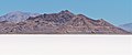
 Tetzlaff Peak (center), Pilot Peak (distant left) from Bonneville Salt Flats
 -
 Southwest aspect
 -
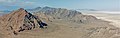 Rishel Peak (left) and Tetzlaff Peak (center) seen from Volcano Peak.
Further in the distance are Graham Peak and Jenkins Peak. -
 Volcano Peak (left), Rishel Peak (left of center) and Tetzlaff Peak (right) from Bonneville Salt Flats
 -
 South aspect
 -
 Rishel Peak (left) and Tetzlaff Peak (right)
 -
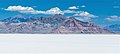
 Tetzlaff Peak and Bonneville Salt Flats
 -
 Tetzlaff Peak (center), Pilot Peak (distant left) from Bonneville Salt Flats


See also
 Mountains portal
- Jenkins Peak
- List of mountain peaks of Utah

References
- ^ United States Geological Survey topographical map - Tetzlaff Peak
- ^ "Tetzlaff Peak, Utah". Peakbagger.com. Retrieved 2022-08-22.
- ^ a b c "Tetzlaff Peak - 6,267' UT". listsofjohn.com. Retrieved 2022-08-22.
- ^ a b "Tetzlaff Peak". Geographic Names Information System. United States Geological Survey, United States Department of the Interior. Retrieved 2022-08-22.
- ^ a b Tony Huegel (2006), Utah Byways: 65 of Utah's Best Backcountry Drives, Wilderness Press, ISBN 9780899974248, p. 26
- ^ Automobile Trade Journal, Volume 19, Chilton Company (1914), p. 93
- ^ Madeleine Osberger, Steve Cohen (1996), Adventure Guide to Utah, Hunter Pub., ISBN 9781556507267, p. 47
- ^ Peel, M. C.; Finlayson, B. L.; McMahon, T. A. (2007). "Updated world map of the Köppen−Geiger climate classification". Hydrol. Earth Syst. Sci. 11. ISSN 1027-5606.
External links
- Tetzlaff Peak: weather forecast
- Pictures of Teddy Tetzlaff by James Walter Collinge


