TDRS-10
American communications satellite
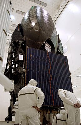 TDRS-J undergoing processing before launch | |
| Mission type | Communication |
|---|---|
| Operator | NASA |
| COSPAR ID | 2002-055A |
| SATCAT no. | 27566 |
| Mission duration | Planned: 20 years Elapsed: 21 years, 5 months, 19 days |
| Spacecraft properties | |
| Bus | BSS-601 |
| Manufacturer | Boeing SDC |
| Launch mass | 3,180 kg (7,010 lb)[1] |
| Start of mission | |
| Launch date | 5 December 2002, 02:42 (2002-12-05UTC02:42) UTC |
| Rocket | Atlas IIA |
| Launch site | Cape Canaveral SLC-36A |
| Contractor | ILS |
| Orbital parameters | |
| Reference system | Geocentric |
| Regime | Geostationary |
| Longitude | 153° West 151° West ~42-40° West (2004—) |
| Perigee altitude | 35,766 kilometers (22,224 mi)[2] |
| Apogee altitude | 35,798 kilometers (22,244 mi)[2] |
| Inclination | 6.09 degrees[2] |
| Period | 1435.86 minutes[2] |
| Epoch | 1 January 2004[2] |
TDRS-10, known before launch as TDRS-J, is an American communications satellite which is operated by NASA as part of the Tracking and Data Relay Satellite System. It was constructed by the Boeing Satellite Development Center, formerly Hughes Space and Communications, and is based on the BSS-601 satellite bus.[3] It was the third and final Advanced TDRS, or second-generation Tracking and Data Relay Satellite, to be launched.
History

The final Atlas IIA rocket was used to launch TDRS-J, under a contract with International Launch Services. The launch occurred at 02:42 UTC on 5 December 2002, from Space Launch Complex 36A at the Cape Canaveral Air Force Station.[4] TDRS-10 separated from its carrier rocket into a geosynchronous transfer orbit. At 01:00 UTC on 14 December, following a series of apogee burns, it reached geostationary orbit.[5]
Deployment
TDRS-J was initially positioned in geostationary orbit at a longitude 153 degrees west of the Greenwich Meridian,[6] and following on-orbit testing, it received the operational designation TDRS-10. In December 2003, it was moved to 151.5° west, arriving the next month. It remained there until June, when it departed for 42.3° west. It arrived there in November, and has since been slowly drifting eastwards. By November 2005, it was at 42° west, and in November 2006, it was recorded to have been at 41.6° west.[6] In July 2009, it was at 40.75° west.[1] In May 2020, it was at 171 degrees west.[7]

See also
 Spaceflight portal

References
- ^ a b "UCS Satellite Database". Union of Concerned Scientists. 1 July 2009. Retrieved 10 August 2009.
- ^ a b c d e McDowell, Jonathan. "Satellite Catalog". Jonathan's Space Page. Retrieved 3 May 2018.
- ^ Krebs, Gunter. "TDRS 8, 9, 10". Gunter's Space Page. Retrieved 10 August 2009.
- ^ McDowell, Jonathan. "Launch Log". Jonathan's Space Page. Retrieved 10 August 2009.
- ^ McDowell, Jonathan. "Index". Geostationary Orbit Catalog. Jonathan's Space Page. Archived from the original on 6 April 2010. Retrieved 10 August 2009.
- ^ a b "TDRS 10". TSE. Retrieved 10 August 2009.
- ^ "TDRS TLE Data". celestrak.org. Retrieved November 20, 2022.
- v
- t
- e

- Italics denotes launch failure.
 | This article about one or more communications satellites is a stub. You can help Wikipedia by expanding it. |
- v
- t
- e
 | This article about one or more spacecraft of the United States is a stub. You can help Wikipedia by expanding it. |
- v
- t
- e


