Superstition Mountains
Landform near Phoenix, Arizona


| Superstition Wilderness | |
|---|---|
| Wi:kchsawa | |
IUCN category Ib (wilderness area)[3] | |
 Praying Hands Formation | |
| Location | Maricopa / Pinal / Gila counties, Arizona, US |
| Nearest city | Apache Junction, Arizona |
| Coordinates | 33°28′41″N 111°14′20″W / 33.47806°N 111.23889°W / 33.47806; -111.23889 |
| Area | 159,757 acres (646.51 km2) |
| Established | 1939 |
| Governing body | United States Forest Service |
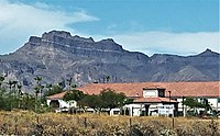
The Superstition Mountains (Yavapai: Wi:kchsawa) is a range of mountains in Arizona located to the east of the Phoenix metropolitan area. They are anchored by Superstition Mountain, a large mountain that is a popular recreation destination for residents of the Phoenix, Arizona, area. They are roughly bounded by U.S. Route 60 on the south, Arizona State Route 88 on the northwest, and Arizona State Route 188 on the northeast.
History and description
The mountains were once known in Spanish as Sierra de la Espuma ("Foam Mountain").
The range has a maximum elevation of 6,266 ft (1,910 m) and prominence of 1,706 ft (520 m) at Mound Mountain in the far eastern section of the range.[4][5][6]
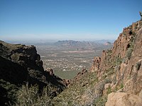
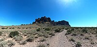
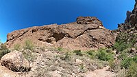
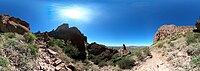
The mountains are in the federally designated Superstition Wilderness Area, and include a variety of natural features in addition to its namesake mountain. Weavers Needle, a prominent landmark and rock climbing destination set behind and to the east of Superstition Mountain, is a tall eroded volcanic remnant[7] that plays a significant role in the legend of the Lost Dutchman's Gold Mine. Numerous hiking trails cross the mountains from multiple access points, including the Peralta Trailhead, the most popular.[8] Peralta Canyon, on the northeast side of Superstition Mountain, contains a popular trail that leads up to Fremont Saddle, which provides a very picturesque view of Weavers Needle. Miner's Needle is another prominent formation in the wilderness and a popular hiking destination. Lost Dutchman State Park, located on the west side of Superstition Mountain, includes several short hiking and mountain bike trails.
Circlestone includes ancient stone monuments.
As with most of the terrain surrounding the Phoenix metropolitan area, the Superstition Mountains have a desert climate, with high summer temperatures and a handful of perennial sources of water. The elevation in the more remote, eastern portion of the wilderness is higher than the western portion, which lowers temperatures slightly.
Legends
The legend of the Lost Dutchman's Gold Mine centers around the Superstition Mountains. According to the legend, a German immigrant named Jacob Waltz discovered a mother lode of gold in the Superstition Wilderness and revealed its location on his deathbed in Phoenix in 1891 to Julia Thomas, a boarding-house owner who had taken care of him for many years. Several mines have been claimed to be the actual mine that Waltz discovered, but none of those claims have been verified.[7] Waltz was a miner at Vulture Mine, where he likely stole the gold and came up with the secret mine to explain his theft. The legends and lore of the Superstition Mountains can be experienced at the Superstition Mountain Museum[9] on the Apache Trail where artifacts of the Lost Dutchman are on display.
Some Apaches believe that the hole leading down into the lower world, or hell, is located in the Superstition Mountains. Winds blowing from the hole are supposed to be the cause of severe dust storms in the metropolitan region.[10]
Nearby towns and cities
- Apache Junction, Arizona
- Gold Canyon, Arizona
- Mesa, Arizona
- Superior, Arizona
- Tortilla Flat, Arizona
Gallery
-
 Miners Needle from Bluff Spring Trail. Note prominent bedding planes in the volcanics. (2010)
 -
 View from the Flatiron hiking trail (2008)
 -
 Superstition Mountains From Route 60 at Apache Junction (2021)
 -
 Mining – of gold, silver and especially copper – has historically been an economically significant activity in the mountains (2014)
 -
 A view from the Apache Trail (Arizona State Route 88) in 2016
 -
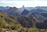 Boulder Canyon Trail – Weaver's Needle in distance (2011)
 -
 Petroglyphs in Superstition Wilderness (2007)
 -
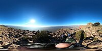 panorama, taken from Flatiron, in the Superstition mountains.
 -
 Ironview Peak (peak 5024) viewed from the Flatiron, on left
 -
 Western Superstition mountains, viewed from Siphon Draw trail.
 -
 Rock formations, Siphon Draw trail.
 -
 Rock formation, Siphon Draw trail.
 -
 view from Superstition Ridgeline Trail
 -
 Panoramic view from Siphon Draw, basin area. .
 -
 Panoramic view from Siphon Draw Trail.
 -
 Panoramic view from Siphon Draw Trail.


See also
References
- ^ "Superstition". NGS Data Sheet. National Geodetic Survey, National Oceanic and Atmospheric Administration, United States Department of Commerce. Retrieved June 8, 2011.
- ^ "Superstition Benchmark, Arizona". Peakbagger.com. Retrieved June 8, 2011.
- ^ "Maps | Data Basin". databasin.org. Retrieved 2018-12-28.
- ^ "Mound Mountain, East Superstition Mountains". peakbagger.com. Retrieved 2016-09-02.
- ^ "East Superstition Mountains". peakbagger.com. Retrieved 2016-09-02.
- ^ "Superstition Mountains Benchmark, Western section". peakbagger.com. Retrieved 2016-09-02.
- ^ a b Kollenborn, Tom (1990). "Weaver's Needle or Picacho?". Archived from the original on 2004-10-30. Retrieved April 1, 2007.
- ^ Carroll, Doug. "Hiking the Supsertitions". Retrieved April 1, 2007.
- ^ Heim, Dave. "Superstition Mountain Museum".
- ^ Vitaliano, Dorothy. 1973. Legends of the Earth, Bloomington: Indiana University Press, pp. 170–171.
External links
Wikimedia Commons has media related to Superstition Mountains.
- HikeArizona.com: Numbered Trails Map
- Official Apache Trail website: Superstition Mountains
- Tonto National Forest: Superstition Wilderness Area Forest Service information
- Wilderness.net: Superstition Wilderness Area
- GORP.com: Superstition Wilderness
- Ajpl.org: History of the Superstitions
- JustRoughinIt.com: Superstition Wilderness Average Climate
- v
- t
- e
(Yavapai County)
- Boundary Cone
- Fortification Hill
- Mount Wilson
- Mount Union
- Castle Dome
- Carr Peak
- Miller Peak
- Aubrey Peak
- Hualapai Peak
- Lime Peak
- Mae West Peaks
- Four Peaks
- Mount Ord
- East End
- McDowell Peak
- Mount McDowell
- Thompson Peak
- Mount Ballard (Arizona)
- Camelback Mountain
- Mummy Mountain
- Piestewa Peak
- South Mountains
- Sunnyslope Mountain
- Ibex Peak
- Agassiz Peak
- Doyle Peak
- Fremont Peak
- Mount Bigelow
- Mount Lemmon
- Pusch Ridge
- Thimble Peak
- Mount Hopkins
- Mount Wrightson
- Mount Turnbull
- Mistake Peak
- Granite Mountain
- Black Dome
- Sentinel Peak
- Tumamoc Hill
- Apache Peak
- Black Mesa (Navajo County)
- Escudilla Mountain
- Mount Baldy
- Agathla Peak
- Agua Caliente Mountains
- Agua Dulce Mountains
- Antelope Hill
- Aquarius Mountains
- Artillery Mountains
- Atascosa Mountains
- Aubrey Hills
- Baboquivari Peak
- Balakai Mesa
- Beaver Dam Mountains
- Belmont Mountains
- Bill Williams Mountain
- Bitsihuitsos Butte
- Black Hills (Greenlee County)
- Black Mesa (Apache-Navajo Counties)
- Black Mesa (Warm Springs)
- Black Mountain (Maricopa County)
- Black Mountain (Pima County)
- Blackjack Mountains
- Bryan Mountains
- Buckskin Mountain (Arizona-Utah)
- Buckskin Mountains (La Paz County)
- Bush Head
- Cabeza Prieta Mountains
- Canelo Hills
- Carrizo Mountains
- Cerro Colorado Mountains
- Chocolate Mountains
- Copper Mountains
- Coyote Mountains
- Date Creek Mountains
- Dome Rock Mountains
- Dos Cabezas Mountains
- Etoi Ki
- Excalibur
- Galiuro Mountains
- Gavilan Peak
- Gila Bend Mountains
- Gila Mountains (Graham County)
- Gila Mountains (Yuma County)
- Goldfield Mountains
- Grand Wash Cliffs
- Granite Mountains
- Granite Wash Mountains
- Growler Mountains
- Gu Achi Peak
- Guadalupe Mountains
- Harcuvar Mountains
- Harquahala Mountains
- House Mountain
- Hunts Mesa
- Isis Temple
- John the Baptist Mountains
- Juniper Mesa
- Kaibab Plateau
- Kofa Mountains
- Laguna Mountains
- Las Guijas Mountains
- Lime Mountain (Maricopa County}
- Little Harquahala Mountains
- Little Rincon Mountains
- Lukachukai Mountains
- Madrean Sky Islands
- Mescal Mountains
- Mineral Mountains
- Moccasin Mountains
- Mohave Mountains
- Mohawk Mountains
- Mount Trumbull
- Muggins Mountains
- Mustang Mountains
- Navajo Mountain
- The Needles
- New River Mountains
- New Water Mountains
- Newton Butte
- Painted Rock Mountains
- Pajarito Mountains
- Patagonia Mountains
- Peacock Mountains
- Picacho Peak
- Picketpost Mountain
- Pinnacle Peak
- Poachie Range
- Poston Butte
- Rawhide Mountains
- Sacaton Mountains
- San Luis Mountains
- Santa Maria Mountains
- Sevenmile Mountains
- Sierra San Antonio
- Sierra Estrella
- Sierra Madre Occidental
- Sierra Pinta
- Silver Bell Mountains
- Squaw Tits
- Sugarloaf Mountain
- Sunset Mountains
- Swisshelm Mountains
- Tempe Butte
- Temple Butte
- Tinajas Altas Mountains
- Tordillo Mountain
- Tortolita Mountains
- Trigo Mountains
- Tule Mountains
- Tumacacori Mountains
- Virgin Mountains
- Vulcan's Throne
- Vulture Mountains
- Waterman Mountains
- Weaver Mountains
- West Silver Bell Mountains
- White Tank Mountains
- Wickenburg Mountains
Authority control databases | |
|---|---|
| International |
|
| National |
|


