Slaughter Mountain
34°44′53″N 83°57′01″W / 34.7481154°N 83.9502741°W / 34.7481154; -83.9502741[2]Geography Location Union County, Georgia, U.S. Parent range Blue Ridge Mountains Topo map USGS Neels Gap Climbing Easiest route Coosa Backcountry Trail, Duncan Ridge Trail 
Slaughter Mountain, with an elevation of 4,338 ft (1,322 m), is the ninth-highest peak in the U.S. state of Georgia.[3] It is located in Union County, Georgia and is the second-highest mountain in Union County. Its nearest higher neighbor is Blood Mountain, the highest peak in Union County and sixth-highest in Georgia.
Slaughter Mountain was named in commemoration of a bloody battle between the Cherokee and Creek Indians.[4]
Gallery
-
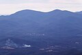 Blood Mountain (L) and Slaughter Mountain (R), as seen from Brasstown Bald
 -
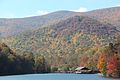 Slaughter Mountain viewed from Vogel State Park
 -
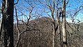 Slaughter Mountain viewed from the Appalachian Trail


See also
- List of mountains in Georgia (U.S. state)
References
- ^ a b "Slaughter Mountain, Georgia". Peakbagger.com. Retrieved 2019-08-04.
- ^ "Slaughter Mountain". Geographic Names Information System. United States Geological Survey, United States Department of the Interior. Retrieved 2019-08-04.
- ^ "Georgia 4000-foot Peaks". Peakbagger.com.
- ^ Krakow, Kenneth K. (1975). Georgia Place-Names: Their History and Origins (PDF). Macon, GA: Winship Press. p. 207. ISBN 0-915430-00-2.
External links
Wikimedia Commons has media related to Slaughter Mountain.
- 100 highest peaks in Georgia
- v
- t
- e
Mountains of Georgia
- Big Bald Mountain
- Big John Dick Mountain
- Black Mountain
- Black Rock Mountain
- Blood Mountain
- Brasstown Bald
- Coosa Bald
- Cowrock Mountain
- Currahee Mountain
- Dick's Knob
- Double Spring Knob
- Flat Top
- Fort Mountain
- Glade Mountain
- Glassy Mountain
- Grassy Mountain
- Grassy Ridge
- Hightower Bald
- Horsetrough Mountain
- Jacks Knob
- Levelland Mountain
- Mount Oglethorpe
- Rabun Bald
- Rich Mountain
- Slaughter Mountain
- Springer Mountain
- Tray Mountain
- Wildcat Mountain
- Wolfpen Ridge
- Young Lick
- Rich Knob
- Screamer Mountain
- Three Sisters
- Yonah Mountain
- Rock Mountain
- Rocky Knob
- Rocky Mountain
- Baugh Mountain
- Blossom Hill
- Horseleg Mountain
- Lookout Mountain
- Lumpkin Hill
- Johns Mountain
- Old Shorter Hill
- Jackson Hill
- Pigeon Mountain
- Snodgrass Hill
- Taylor Ridge
- Turkey Mountain
- White Oak Mountain
- Alcovy Mountain
- Arabia Mountain
- Bear Mountain
- Blackjack Mountain
- Chenocetah Mountain
- Dowdell's Knob
- Heggie's Rock
- Kennesaw Mountain
- Little Kennesaw Mountain
- Mount Wilkinson
- Panola Mountain
- Pine Log Mountain
- Pine Mountain (Bartow County)
- Pine Mountain (Cobb County)
- Pine Mountain Range
- Sawnee Mountain
- Stone Mountain
- Sweat Mountain


