Skrapar
Municipality in Berat, Albania

Flag

Emblem
(2022 [citation needed])
5401-5402
Skrapar (Albanian definite form: Skrapari) is a municipality in Berat County, southern Albania. It was created in 2015 by the merger of the former municipalities Bogovë, Çepan, Çorovodë, Gjerbës, Leshnjë, Potom, Qendër Skrapar, Vendreshë and Zhepë. The seat of the municipality is the town Çorovodë.[1] The total population is 12,403 (2011 census),[2] in a total area of 832.04 km2.[3] It covers part of the area of the former Skrapar District, without the town Poliçan.
It is also roughly contiguous with the Albanian "ethnographic region" of Skrapar which is known for its folklore, its raki production, its high rate of those belonging to the Bektashi order and its scenic mountains.
History
The discovery of the cave settlements, graves, mosaics, coins and the ruins of bridges, churches, castles, have extended knowledge and evidence of an ancient human life in the area. Ancient objects are work tools belonging to the Neolithic period. Illyrian-Roman wars, come out through the pen of historians of different times like, Orgesi, Koragu, Gerunti, etc. According to them, the town was established in III century BC and Illyrians served as a fortress area of Skrapar and strategic character defence.[4] During the Ottoman period, the region was known as İskarapar.
Gallery
-
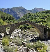 Kasabashi Bridge near Çorovodë
 -
 Osum Canyon
 -
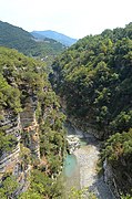
 Osum river and Tomorr in the background


See also
References
- ^ "Law nr. 115/2014" (PDF) (in Albanian). p. 6366. Retrieved 25 February 2022.
- ^ "Population and housing census - Berat 2011" (PDF). INSTAT. Retrieved 2019-09-25.
- ^ "Correspondence table LAU – NUTS 2016, EU-28 and EFTA / available Candidate Countries" (XLS). Eurostat. Retrieved 2019-09-25.
- ^ "Blue Albania - We help you to explore Albania... - Portali me i madh turistik Shqiptar". BlueAlbania. Retrieved 23 April 2018.
External links
- Visit Skrapar
- v
- t
- e
The municipalities of Albania are the country's administrative divisions consisting of local administrative units and their inclusive villages.
- Bulqizë
- Dibër
- Klos
- Mat
- Divjakë
- Fier
- Lushnjë
- Mallakastër
- Patos
- Roskovec
Subdivisions of Berat County | ||
|---|---|---|
County Seat: Berat | ||
| Municipality of Berat |  | |
| Municipality of Dimal | ||
| Municipality of Kuçovë | ||
| Municipality of Poliçan | ||
| Municipality of Skrapar | ||
Subdivisions of Skrapar Municipality | ||
|---|---|---|
Municipal Seat: Çorovodë | ||
| Administrative Unit of Bogovë |  | |
| Administrative Unit of Çepan | ||
| Administrative Unit of Çorovodë | ||
| Administrative Unit of Gjerbës | ||
| Administrative Unit of Leshnjë | ||
| Administrative Unit of Potom | ||
| Administrative Unit of Qendër Skrapar | ||
| Administrative Unit of Vendreshë | ||
| Administrative Unit of Zhepë | ||
Authority control databases | |
|---|---|
| International |
|
| National |
|
 | This article about a specific location in Berat County, Albania, is a stub. You can help Wikipedia by expanding it. |
- v
- t
- e


