River Suir Bridge
Bridge in Waterford City
52°16′44″N 7°09′04″W / 52.27881°N 7.151°W / 52.27881; -7.151- Cars: €2.10
- Motorcycles: €1.10
- Coaches: €3.80
- Light commercial: €3.80
- Trucks: €5.40 - €6.80

The River Suir Bridge is a cable-stayed bridge over the River Suir in Ireland. It was built as part of the N25 Waterford Bypass,[2] and opened to traffic on 19 October 2009, some ten months ahead of schedule.[3] The Viking settlement at Woodstown was discovered during the project and the route of the southern approach roads was altered to preserve the site.
The 230 metre main span had the longest single bridge span in the Republic of Ireland, until the opening of the Rose Fitzgerald Kennedy Bridge, taking that record from the Boyne River Bridge on the Dublin to Belfast M1 motorway. By comparison, the main span of the Foyle Bridge in Northern Ireland is four metres longer.
Overview
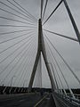
The cable-stayed bridge with its 112 metre tall tower, is a landmark structure for Waterford City and surrounding areas. The tower is constructed on the south side of the river. A series of "stay cables" fan out from the top of the tower to support the main span at intervals of about 10 metres. Corresponding cables fan to the back spans using the weight of the back span and anchor piles to balance the forces and "keep the tower standing straight".[3][4]
Other bridges at Waterford City
- The first permanent bridge at Waterford City was the so-called "Timbertoes" bridge (1793-1913)
- It was replaced by the Redmond Bridge (1910-1984)
- The current city-centre bridge is the Rice Bridge (1982–present)
- The River Suir Bridge marks the first time Waterford city has been served by two bridges
Gallery
-
 The Suir Bridge under construction in April 2009
 -
 The tower on opening day
 -
 Close-up of the tower on opening day
 -
 Opening day


See also
- Roads in Ireland
- Atlantic Corridor
- List of Ireland-related topics
References
- ^ "Archived copy" (PDF). Archived from the original (PDF) on 14 August 2012. Retrieved 17 November 2012.
{{cite web}}: CS1 maint: archived copy as title (link) - ^ "N25 Waterford City Bypass". National Roads Authority. Retrieved 5 November 2010.
- ^ a b "River Suir Bridge". Waterford City Council. Archived from the original on 14 September 2008. Retrieved 13 September 2008.
- ^ "The N25 Waterford Bypass PPP Scheme" (PDF). Celtic Roads Group Waterford. 1 (5). Grannagh, Co. Kilkenny: National Roads Authority. June 2008. Retrieved 13 September 2008.
52°16′44″N 7°09′04″W / 52.2788°N 7.151°W / 52.2788; -7.151


