Rambla del Poyo
You can help expand this article with text translated from the corresponding article in Spanish. (July 2010) Click [show] for important translation instructions.
- View a machine-translated version of the Spanish article.
- Machine translation, like DeepL or Google Translate, is a useful starting point for translations, but translators must revise errors as necessary and confirm that the translation is accurate, rather than simply copy-pasting machine-translated text into the English Wikipedia.
- Do not translate text that appears unreliable or low-quality. If possible, verify the text with references provided in the foreign-language article.
- You must provide copyright attribution in the edit summary accompanying your translation by providing an interlanguage link to the source of your translation. A model attribution edit summary is
Content in this edit is translated from the existing Spanish Wikipedia article at [[:es:Rambla del Poyo]]; see its history for attribution. - You may also add the template
{{Translated|es|Rambla del Poyo}}to the talk page. - For more guidance, see Wikipedia:Translation.

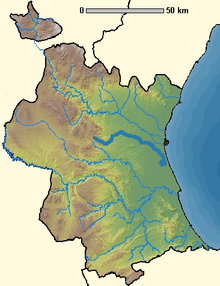
The Rambla del Poyo is a 41 km Rambla in the Province of Valencia, Spain.
It lies between the Turia and Júcar rivers, with its source in the mountains of the Parque Natural del Turia, and the mouth at the Albufera de Valencia by the Mediterranean Sea.
References
39°22′43″N 0°21′23″W / 39.3786°N 0.3564°W / 39.3786; -0.3564
- v
- t
- e
This article related to a river in Spain is a stub. You can help Wikipedia by expanding it. |
- v
- t
- e


