Rajčanka
River
| Rajčanka | |
|---|---|
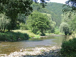 River near Porúbka | |
| Physical characteristics | |
| Source | |
| • location | Strážovské vrchy |
| Mouth | |
• location | Váh in Žilina |
• coordinates | 49°14′07″N 18°42′31″E / 49.2352°N 18.7085°E / 49.2352; 18.7085 |
| Length | 46.6 km (29.0 mi) |
| Basin size | 359 km2 (139 sq mi) |
| Basin features | |
| Progression | Váh→ Danube→ Black Sea |
Rajčanka or Rajčianka (Hungarian: Rajcsánka) is a river in northern Slovakia springing in Strážovské vrchy near Čičmany and pouring into Váh in Žilina. It is 46.6 km (29.0 mi) long and its basin size is 359 km2 (139 sq mi).[1]
It forms the border of Lúčanská Malá Fatra Mountains and of Strážovské vrchy. 32 km of its length are navigable.
Cities along its course are: Rajec, Rajecké Teplice, Žilina.
Names and etymology
The original name of the river was Lietava, later Žilinka and only after the founding of Rajec (the 14th century) also Rajčanka[2] (see also Etymology of Rajec).
References
- v
- t
- e
Hydrography of Slovakia
| Black Sea basin |
| ||||
|---|---|---|---|---|---|
| Baltic Sea basin |
|
| Tarns in Tatra Mountains | |
|---|---|
| Other natural lakes |
|
| Váh basin |
|
|---|---|
| Other |
|
| Authority control databases: National |
|
|---|
This article related to a river in Slovakia is a stub. You can help Wikipedia by expanding it. |
- v
- t
- e


