Plaveč, Stará Ľubovňa District
Village and municipality in Slovakia

Plaveč (German: Plautsch; Hungarian: Palocsa; Rusyn: Плавеч; Polish: Pławiec) is a village and municipality in Stará Ľubovňa District in the Prešov Region of northern Slovakia.
Etymology
Plavec (Polovtsian in Slovak) → Plaveč.[1]
History
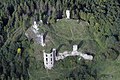
In historical records the village was first mentioned in 1287. The ruins of the 13th century Plaveč Castle lie above the town, after a fire in 1856.[2] Before the establishment of independent Czechoslovakia in 1918, Plaveč was part of Sáros County within the Kingdom of Hungary. From 1939 to 1945, it was part of the Slovak Republic. On 23 January 1945, the Red Army dislodged the Wehrmacht from Plaveč and it was once again part of Czechoslovakia.
Geography
The municipality lies at an altitude of 488 metres and covers an area of 16.683 km². It has a population of about 1857 people.

References
- ^ Krajčovič, Rudolf (2014). "Z lexiky stredovekej slovenčiny s výkladmi názvov obcí a miest (48)". Kultúra slova (in Slovak) (6). Martin: Vydavateľstvo Matice slovenskej: 331.
- ^ "Plaveč Castle".
External links
- http://www.statistics.sk/mosmis/eng/run.html
Wikimedia Commons has media related to Plaveč.
- v
- t
- e
Municipalities of Stará Ľubovňa District
- Čirč
- Ďurková
- Forbasy
- Hajtovka
- Haligovce
- Hniezdne
- Hraničné
- Hromoš
- Chmeľnica
- Jakubany
- Jarabina
- Kamienka
- Kolačkov
- Kremná
- Kyjov
- Lacková
- Legnava
- Lesnica
- Litmanová
- Lomnička
- Ľubotín
- Malý Lipník
- Matysová
- Mníšek nad Popradom
- Nižné Ružbachy
- Nová Ľubovňa
- Obručné
- Orlov
- Plaveč
- Plavnica
- Pusté Pole
- Ruská Voľa nad Popradom
- Starina
- Stráňany
- Sulín
- Šambron
- Šarišské Jastrabie
- Údol
- Veľká Lesná
- Veľký Lipník
- Vislanka
- Vyšné Ružbachy

49°16′N 20°51′E / 49.267°N 20.850°E / 49.267; 20.850
| Authority control databases |
|
|---|
 | This Prešov Region geography article is a stub. You can help Wikipedia by expanding it. |
- v
- t
- e


