Pedra Azul State Park
20°24′07″S 41°01′26″W / 20.402°S 41.024°W / -20.402; -41.024Area 1,240 hectares (3,100 acres) Designation State park Created 1991 
Pedra Azul State Park (Portuguese: Parque Estadual de Pedra Azul) is a state park in the state of Espírito Santo, Brazil.
Location
The Pedra Azul State Park was created in 1991 to protect the natural heritage of the region, and in particular the Pedra Azul (Blue Stone), a granite rock formation reaching a height of 1,822 metres (5,978 ft). The park covers 1,240 hectares (3,100 acres). Temperatures range from about 7.3 to 27.8 °C (45.1 to 82.0 °F). Altitude ranges from 1,250 metres (4,100 ft) at the visitor center to 1,909 metres (6,263 ft) at the peak of Pedra das Flores, the highest point. The park covers parts of the municipalities of Domingos Martins and Vargem Alta.[1] It became part of the Central Atlantic Forest Ecological Corridor, created in 2002.[2]
Gallery
-
 Pedra Azul beneath the Milky Way
 -
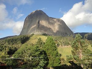 The blue Rock
 -
 Lizard Rock attached to the Blue Rock
 -
 The lizard Rock attached to the Blue Rock
 -
 Natural Pool on Blue Rock
 -
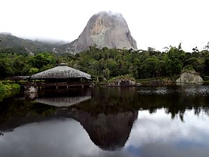 Pedra Azul as seen from the Dark Lake


Notes
Sources
Wikivoyage has a travel guide for Pedra Azul State Park.
Wikimedia Commons has media related to Parque Estadual da Pedra Azul.
- Lamas, Ivana Reis; Crepaldi, Maria Otávia; Mesquita, Carlos Alberto Bernardo (2015), Uma Rede no Corredor (PDF) (in Portuguese), Conservação Internacional (CI-Brasil), ISBN 978-85-98830-28-5, retrieved 2016-10-22
- Parque Estadual de Pedra Azul (in Portuguese), Pedra Azul do Aracê, retrieved 2016-05-02
| Authority control databases |
|
|---|


