Paranoá, Federal District

Flag
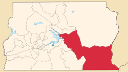
Localization of Paranoá in Federal District
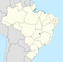
 Brazil
 Federal District
 (2010)[2]
71570-000
Paranoá is an administrative region in the Federal District in Brazil. It is located to the east of Paranoá Lake, being bordered by Lago Norte, Itapoã and Planaltina to the north, São Sebastião and Jardim Botânico to the south. It shares a border with Lago Sul and Brasília through Paranoá Lake. Paranoá was founded on October 25, 1957, receiving the status of administrative region, according to Law 4545, of December 10, 1964. As of a 2010 census, it has a population of 46,527.
Etymology
The name Paranoá comes from Paranoá Lake, which the region is located near.
Sports
Venues
- Estádio JK Paranoá
Clubs
See also
- List of administrative regions of the Federal District
References
External links
Wikimedia Commons has media related to Paranoá.
- Regional Administration of Paranoá website
- Government of the Federal District website
- v
- t
- e
 Administrative regions of the Federal District
Seat of government: Brasília


 | This Federal District, Brazil geography article is a stub. You can help Wikipedia by expanding it. |
- v
- t
- e


