Panykang County
County in Greater Upper Nile, South Sudan
Panykang | |
|---|---|
| Country | South Sudan |
| Region | Greater Upper Nile |
| State | Upper Nile State |
| Area | |
| • Total | 5,038 km2 (1,945 sq mi) |
| Population (2017 estimate[1]) | |
| • Total | 65,117 |
| • Density | 13/km2 (33/sq mi) |
| Time zone | UTC+2 (CAT) |
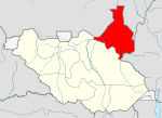
Panykang County is an administrative area in Upper Nile State, in the Greater Upper Nile region of South Sudan.[2]
References
9°26′10″N 31°21′24″E / 9.43611°N 31.35667°E / 9.43611; 31.35667
 | This South Sudan location article is a stub. You can help Wikipedia by expanding it. |
- v
- t
- e


