Oldany Island
Tidal island in Assynt, Sutherland, north-west Scotland
58°16′N 5°16′W / 58.26°N 5.26°W / 58.26; -5.26

Oldany Island (formerly Oldney Island) is an uninhabited island in Assynt, Sutherland, north-west Scotland.
The name is Norse in origin and possibly means fruit.[6]
Geography
Oldany Island is a large tidal island at the southwestern entrance to Eddrachillis Bay/Kylesku. It has an area of 200 hectares (500 acres) and its highest point is Sìdhean nan Ealachan (The Swans' Fairy Mound) at 104 metres (341 ft).[1] Handa Island is to the north, across Eddrachillis Bay; Eilean Chrona is to the south west and Sgeir nan Gall (Norsemen's Skerry) is to the north. The island is part of the Assynt-Coigach National Scenic Area, one of 40 in Scotland.[7]
The settlement of Oldany is on the adjacent mainland. The island has long been used for grazing sheep. Oldany island is owned by the Turner family.[8]
-
 View of Oldany Island from Culkein Drumbeg (mainland), showing many of the islets to the island's east.
 -
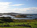
 Oldany Island on the right, seen from the mainland (left)


Notes and references
- ^ a b c "Overview of Oldany". Gazetteer for Scotland. Retrieved 14 December 2007.
- ^ Area and population ranks: there are c. 300 islands over 20 ha in extent and 93 permanently inhabited islands were listed in the 2011 census.
- ^ National Records of Scotland (15 August 2013). "Appendix 2: Population and households on Scotland's Inhabited Islands" (PDF). Statistical Bulletin: 2011 Census: First Results on Population and Household Estimates for Scotland Release 1C (Part Two) (PDF) (Report). SG/2013/126. Retrieved 14 August 2020.
- ^ Haswell-Smith, Hamish. (2004) The Scottish Islands. Edinburgh. Canongate.
- ^ Ordnance Survey: Landranger map sheet 15 Loch Assynt (Lochinver & Kylesku) (Map). Ordnance Survey. 2012. ISBN 9780319231265.
- ^ Place names Highlands & Islands of Scotland. Alex. Macbain. 1922. ISBN 9785878525244. Retrieved 26 October 2018.
- ^ "National Scenic Areas" Archived 2017-03-11 at the Wayback Machine. SNH. Retrieved 30 Mar 2011.
- ^ "Property Page:Oldany". Who owns Scotland. Retrieved 21 January 2008.[dead link] Alt URL
Wikimedia Commons has media related to Oldany Island.
58°15.5′N 5°15.5′W / 58.2583°N 5.2583°W / 58.2583; -5.2583
- v
- t
- e
Uninhabited islands of the Hebrides
- Calbha Beag
- Calbha Mor
- Calve Island
- Cara
- Càrna
- Eileach an Naoimh
- Eilean an Ròin Mòr
- Eilean Dubh Mòr
- Eilean Fladday
- Eilean Horrisdale
- Eilean Ighe
- Eilean Macaskin
- Eilean Meadhonach
- Eilean Mhic Chrion
- Eilean Mòr
- Eilean Rìgh
- Eilean Tigh
- Eilean Trodday
- Eorsa
- Garbh Eileach
- Gruinard
- Gunna
- Handa
- Harlosh Island
- Horse Island
- Inch Kenneth
- Insh
- Isay
- Isle Martin
- Isle Ristol
- Little Colonsay
- Longa Island
- Longay
- Lunga
- Oldany Island
- Ornsay
- Oronsay
- Pabay
- Priest Island
- Scarba
- Shuna
- Staffa
- Tanera Beag
- Texa
- Torsa
- Wiay

- Barra Head
- Boreray
- Calbhaigh
- Ceabhaigh
- Ceallasaigh Beag
- Ceallasaigh Mòr
- Ceann Ear
- Ceann Iar
- Eilean Chaluim Chille
- Eilean Chearstaidh
- Eileanan Iasgaich
- Eilean Liubhaird
- Eilean Mhealasta
- Eilean Mhuire
- Ensay
- Fiaraidh
- Flodaigh
- Flodaigh Mòr
- Flodday
- Flodday
- Fodragaigh
- Fuaigh Beag
- Fuaigh Mòr
- Fuday
- Fuiay
- Garbh Eilean
- Gasker
- Gighay
- Groaigh
- Haskeir
- Haskeir Eagach
- Hellisay
- Hermetray
- Killegray
- Kirkibost
- Lingeigh
- Little Bernera
- Mingulay
- Muldoanich
- Orosay
- Oronsay
- Pabbay
- Pabaigh Mòr
- Ronay
- Sandray
- Scarp
- Seaforth Island
- Sgeotasaigh
- Sibhinis
- Shillay
- Soay Mòr
- Stromay
- Stockinish Island
- Stuley
- Sursaigh
- Tahay
- Taransay
- Trialabreac
- Torogaigh
- Vacsay
- Vallay
- Wiay
 | This Highland location article is a stub. You can help Wikipedia by expanding it. |
- v
- t
- e


