Olallie State Park
State park in Washington (state), United States
47°26′46″N 121°42′14″W / 47.44611°N 121.70389°W / 47.44611; -121.70389[1]
Olallie State Park is a public recreation area featuring multiple waterfalls located five miles (8.0 km) southeast of North Bend, Washington.[2] The state park spans a 3.5-mile (5.6 km) stretch along the South Fork of the Snoqualmie River.[3] The most prominent feature of the park is 135-foot-high (41 m) Twin Falls.[4]
History
The park originated in 1950, when Washington State Parks purchased a 160-acre parcel from Puget Sound Power and Light. Originally named Twin Falls State Park, following the park's expansion in 1976 its name was changed to Olallie, after a Chinook word for the berries which are common in the park.[2]
Features
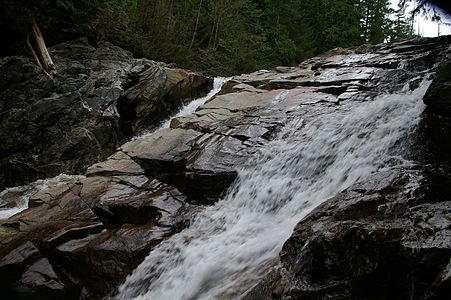
The park features old-growth forests and five notable waterfalls: Twin Falls, Middle Twin Falls, Upper Twin Falls, Weeks Falls, and Upper Weeks Falls.
Twin Falls features a well-hidden underground run-of-the-river hydroelectric project that generates 24 MW of electricity.[5] The powerhouse is located 325 feet (99 m) below ground.
-
 Upper Twin Falls
 -
 Middle Twin Falls
 -
 Lower Fall of Twin Falls
 -
 Upper Weeks Falls
 -
 Weeks Falls


Activities and amenities
Park activities include fishing, hiking, mountain biking, bird watching, and rock climbing.[2] Completed in 2017, the Ollalie Trail added 9.2 miles (14.8 km) of backcountry mountain biking.[6]
References
- ^ a b "Twin Falls State Park". Geographic Names Information System. United States Geological Survey, United States Department of the Interior.
- ^ a b c "Olallie State Park". Washington State Parks and Recreation Commission. Retrieved May 11, 2015.
- ^ Karen Sykes (April 24, 2002). "Hike of the Week: Big trees, waterfalls and spring flowers". Seattle PI. Take a Hike. Retrieved March 31, 2007.
- ^ "Twin Falls, King County". Northwest Waterfall Survey. April 24, 2002. Retrieved March 31, 2007.
- ^ "Twin Falls Hydroelectric Project". Archived from the original on March 4, 2016.
- ^ "New backcountry trail opens at Olallie". Mountains to Sound Greenway Trust. October 1, 2017. Retrieved October 25, 2017.
External links
Wikimedia Commons has media related to Olallie State Park.
- Olallie State Park Washington State Parks and Recreation Commission
- Olallie State Park Map Washington State Parks and Recreation Commission
- v
- t
- e
Protected areas of Washington
| Former state parks |
|---|
- Marine protected areas
- Blanchard Forest
- Cascadia Marine Trail
- The Enchantments
- Goose Island
- Les Hilde Trail & Trailheads
- Little Pend Oreille
- Maritime Washington National Heritage Area
- Mount Adams Recreation Area
- Sehome Hill Arboretum
- Walker Valley ORV Riding Area
- Withrow Moraine
- Yellow Island

| Authority control databases |
|
|---|


