National Register of Historic Places listings in Southbridge, Massachusetts
Map all coordinates using OpenStreetMap
Download coordinates as:
- KML
- GPX (all coordinates)
- GPX (primary coordinates)
- GPX (secondary coordinates)
The following properties in Southbridge, Massachusetts are listed on the National Register of Historic Places.
This National Park Service list is complete through NPS recent listings posted June 14, 2024.[1]
Southbridge
| [2] | Name on the Register | Image | Date listed[3] | Location | Description |
|---|---|---|---|---|---|
| 1 | Academie Brochu |  | June 22, 1989 (#89000568) | 29 Pine St. 42°04′46″N 72°02′17″W / 42.079444°N 72.038056°W / 42.079444; -72.038056 (Academie Brochu) | |
| 2 | William E. Alden House |  | June 22, 1989 (#89000562) | 428 Hamilton St. 42°04′55″N 72°02′28″W / 42.081944°N 72.041111°W / 42.081944; -72.041111 (William E. Alden House) | |
| 3 | Alden-Delahanty Block |  | June 22, 1989 (#89000572) | 858 Main St. 42°04′54″N 72°02′46″W / 42.081667°N 72.046111°W / 42.081667; -72.046111 (Alden-Delahanty Block) | |
| 4 | American Optical Company Historic District | 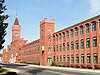 | May 3, 2023 (#100008957) | Optical Dr., Mechanic, Case, Cabot, Charlton, Main, and Wells Sts. 42°04′29″N 72°01′24″W / 42.0746°N 72.0233°W / 42.0746; -72.0233 (American Optical Company Historic District) | |
| 5 | Ammidown-Harding Farmhouse |  | June 22, 1989 (#89000552) | 83 Lebanon Hill Rd. 42°03′35″N 72°02′05″W / 42.059722°N 72.034722°W / 42.059722; -72.034722 (Ammidown-Harding Farmhouse) | |
| 6 | Ashland Mill Tenement |  | June 22, 1989 (#89000545) | 141–145 Ashland Ave. 42°03′55″N 72°00′37″W / 42.065278°N 72.010278°W / 42.065278; -72.010278 (Ashland Mill Tenement) | |
| 7 | Bacon-Morse Historic District |  | June 22, 1989 (#89000602) | N. Woodstock Rd. at Tipton Rock Rd. 42°02′09″N 72°00′48″W / 42.035833°N 72.013333°W / 42.035833; -72.013333 (Bacon-Morse Historic District) | |
| 8 | Beechwood |  | June 22, 1989 (#89000527) | 495 Main St. 42°04′38″N 72°02′18″W / 42.077222°N 72.038333°W / 42.077222; -72.038333 (Beechwood) | |
| 9 | Alexis Boyer House |  | June 22, 1989 (#89000560) | 306 Hamilton 42°04′53″N 72°02′16″W / 42.081389°N 72.037778°W / 42.081389; -72.037778 (Alexis Boyer House) | |
| 10 | Building at 25–27 River Street |  | June 22, 1989 (#89000574) | 25–27 River St. 42°04′56″N 72°02′21″W / 42.082222°N 72.0391°W / 42.082222; -72.0391 (Building at 25–27 River Street) | |
| 11 | Building at 29–31 River Street |  | June 22, 1989 (#89000575) | 29–31 River St. 42°04′56″N 72°02′21″W / 42.082222°N 72.0392°W / 42.082222; -72.0392 (Building at 29–31 River Street) | |
| 12 | Building at 38–42 Worcester Street |  | June 22, 1989 (#89000589) | 38–42 Worcester St. 42°04′46″N 72°01′47″W / 42.0794°N 72.0297°W / 42.0794; -72.0297 (Building at 38–42 Worcester Street) | |
| 13 | Building at 52 Main Street | 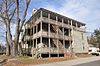 | June 22, 1989 (#89000583) | 52 Main St. 42°04′24″N 72°01′39″W / 42.0733°N 72.0275°W / 42.0733; -72.0275 (Building at 52 Main Street) | |
| 14 | Central Mills Historic District |  | June 22, 1989 (#89000595) | Roughly bounded by the Quinebaug River, North St., and Central St. 42°04′37″N 72°01′53″W / 42.0769°N 72.0314°W / 42.0769; -72.0314 (Central Mills Historic District) | |
| 15 | Centre Village Historic District |  | September 7, 1979 (#79000379) | Along Main St. 42°04′32″N 72°02′04″W / 42.0755°N 72.0345°W / 42.0755; -72.0345 (Centre Village Historic District) | |
| 16 | Chamberlain-Bordeau House |  | June 22, 1989 (#89000569) | 718 Main St. 42°04′49″N 72°02′35″W / 42.0803°N 72.0431°W / 42.0803; -72.0431 (Chamberlain-Bordeau House) | |
| 17 | Chapin Block | 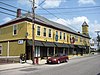 | June 22, 1989 (#89000558) | 208–222 Hamilton 42°04′48″N 72°02′08″W / 42.08°N 72.0356°W / 42.08; -72.0356 (Chapin Block) | |
| 18 | Alpha M. Cheney House |  | June 22, 1989 (#89000526) | 61 Chestnut St. 42°04′16″N 72°01′39″W / 42.0711°N 72.0275°W / 42.0711; -72.0275 (Alpha M. Cheney House) | |
| 19 | J.M. Cheney Rental House |  | June 22, 1989 (#89000564) | 32 Edwards St. 42°04′44″N 72°02′10″W / 42.0789°N 72.0361°W / 42.0789; -72.0361 (J.M. Cheney Rental House) | |
| 20 | Clarke-Glover Farmhouse |  | June 22, 1989 (#89000536) | 201 South St. 42°04′34″N 72°02′45″W / 42.0761°N 72.0458°W / 42.0761; -72.0458 (Clarke-Glover Farmhouse) | |
| 21 | Cliff Cottage |  | June 22, 1989 (#89000570) | 787 Mill St. 42°05′01″N 72°02′29″W / 42.083611°N 72.041389°W / 42.083611; -72.041389 (Cliff Cottage) | |
| 22 | E. Merritt Cole House |  | June 22, 1989 (#89000576) | 386 Main St. 42°04′36″N 72°02′08″W / 42.076667°N 72.035556°W / 42.076667; -72.035556 (E. Merritt Cole House) | |
| 23 | Comins-Wall House | 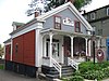 | June 22, 1989 (#89000555) | 42 Hamilton St. 42°04′35″N 72°02′04″W / 42.076389°N 72.034444°W / 42.076389; -72.034444 (Comins-Wall House) | |
| 24 | Congregational Church |  | June 22, 1989 (#89000591) | 61 Elm St. 42°04′23″N 72°02′06″W / 42.0731°N 72.035°W / 42.0731; -72.035 (Congregational Church) | |
| 25 | E. B. Cummings House |  | June 22, 1989 (#89000566) | 52 Marcy St. 42°04′43″N 72°02′15″W / 42.0786°N 72.0375°W / 42.0786; -72.0375 (E. B. Cummings House) | |
| 26 | Dani and Soldani Cabinet Makers and Wood Workers Factory |  | June 22, 1989 (#89000529) | 484 Worcester St. 42°05′26″N 72°01′22″W / 42.0906°N 72.0228°W / 42.0906; -72.0228 (Dani and Soldani Cabinet Makers and Wood Workers Factory) | |
| 27 | Dennison School House |  | June 22, 1989 (#89000551) | Dennison Ln. 42°03′38″N 72°03′42″W / 42.0606°N 72.0617°W / 42.0606; -72.0617 (Dennison School House) | |
| 28 | Sylvester Dresser House |  | June 22, 1989 (#89000523) | 29 Summer St. 42°04′18″N 72°02′05″W / 42.0717°N 72.0347°W / 42.0717; -72.0347 (Sylvester Dresser House) | |
| 29 | Dunbar-Vinton House |  | June 22, 1989 (#89000573) | Hook and Hamilton Sts. 42°04′38″N 72°02′03″W / 42.0772°N 72.0342°W / 42.0772; -72.0342 (Dunbar-Vinton House) | |
| 30 | Henry E. Durfee Farmhouse |  | June 22, 1989 (#89000547) | 281 Eastford Rd. 42°03′49″N 72°02′33″W / 42.0636°N 72.0425°W / 42.0636; -72.0425 (Henry E. Durfee Farmhouse) | |
| 31 | Elm Street Fire House |  | June 22, 1989 (#89000530) | 24 Elm St. 42°04′27″N 72°02′06″W / 42.074167°N 72.035°W / 42.074167; -72.035 (Elm Street Fire House) | |
| 32 | Evangelical Free Church |  | June 22, 1989 (#89000561) | Hamilton St. 42°04′55″N 72°02′29″W / 42.081944°N 72.041389°W / 42.081944; -72.041389 (Evangelical Free Church) | |
| 33 | James Gleason Cottage |  | June 22, 1989 (#89000533) | 31 Sayles St. 42°04′45″N 72°02′37″W / 42.079167°N 72.043611°W / 42.079167; -72.043611 (James Gleason Cottage) | |
| 34 | Globe Village Fire House |  | June 22, 1989 (#89000540) | West St. at Main St. 42°04′47″N 72°02′45″W / 42.0797°N 72.0458°W / 42.0797; -72.0458 (Globe Village Fire House) | |
| 35 | Glover Street Historic District |  | June 22, 1989 (#89000601) | Glover St. between High and Poplar Sts. 42°04′28″N 72°02′49″W / 42.074444°N 72.046944°W / 42.074444; -72.046944 (Glover Street Historic District) | |
| 36 | Hamilton Mill Brick House |  | June 22, 1989 (#89000542) | 16 High St. 42°04′48″N 72°02′43″W / 42.08°N 72.0453°W / 42.08; -72.0453 (Hamilton Mill Brick House) | |
| 37 | Hamilton Mill-West Street Factory Housing |  | June 22, 1989 (#89000541) | 45 West St. 42°04′46″N 72°02′47″W / 42.0794°N 72.0464°W / 42.0794; -72.0464 (Hamilton Mill-West Street Factory Housing) | |
| 38 | Hamilton Millwright-Agent's House |  | June 22, 1989 (#89000543) | 757–761 Main St. 42°04′48″N 72°02′40″W / 42.08°N 72.0444°W / 42.08; -72.0444 (Hamilton Millwright-Agent's House) | |
| 39 | Hamilton Woolen Company Historic District |  | June 22, 1989 (#89000594) | Roughly bounded by McKinstry Brook, the Quinebaug River, and Mill St. 42°04′56″N 72°02′37″W / 42.0822°N 72.0436°W / 42.0822; -72.0436 (Hamilton Woolen Company Historic District) | |
| 40 | Theodore Harrington House |  | June 22, 1989 (#89000557) | 77 Hamilton St. 42°04′37″N 72°02′07″W / 42.0769°N 72.0353°W / 42.0769; -72.0353 (Theodore Harrington House) | |
| 41 | George H. Hartwell House |  | June 22, 1989 (#89000556) | 105 Hamilton St. 42°04′39″N 72°02′08″W / 42.0775°N 72.0356°W / 42.0775; -72.0356 (George H. Hartwell House) | |
| 42 | Samuel C. Hartwell House |  | June 22, 1989 (#89000592) | 79 Elm St. 42°04′22″N 72°02′07″W / 42.0728°N 72.0353°W / 42.0728; -72.0353 (Samuel C. Hartwell House) | |
| 43 | High-School Streets Historic District |  | June 22, 1989 (#89000600) | High St. at School St. 42°04′40″N 72°02′45″W / 42.0778°N 72.0458°W / 42.0778; -72.0458 (High-School Streets Historic District) | |
| 44 | William Hodgson Two-Family House |  | June 22, 1989 (#89000578) | 103–105 Sayles St. 42°04′38″N 72°02′38″W / 42.0772°N 72.0439°W / 42.0772; -72.0439 (William Hodgson Two-Family House) | Probably demolished. |
| 45 | House at 3 Dean Street |  | June 22, 1989 (#89000587) | 3 Dean St. 42°04′32″N 72°01′42″W / 42.0756°N 72.0283°W / 42.0756; -72.0283 (House at 3 Dean Street) | |
| 46 | House at 18 Walnut Street |  | June 22, 1989 (#89000580) | 18 Walnut St. 42°04′25″N 72°01′46″W / 42.0736°N 72.0294°W / 42.0736; -72.0294 (House at 18 Walnut Street) | |
| 47 | House at 34 Benefit Street |  | June 22, 1989 (#89000585) | 34 Benefit St. 42°04′31″N 72°01′46″W / 42.075278°N 72.029444°W / 42.075278; -72.029444 (House at 34 Benefit Street) | |
| 48 | House at 59–63 Crystal Street |  | June 22, 1989 (#89000584) | 59–63 Crystal St. 42°04′29″N 72°01′40″W / 42.074722°N 72.027778°W / 42.074722; -72.027778 (House at 59–63 Crystal Street) | |
| 49 | House at 64 Main Street |  | June 22, 1989 (#89000582) | 64 Main St. 42°04′23″N 72°01′41″W / 42.073056°N 72.028056°W / 42.073056; -72.028056 (House at 64 Main Street) | |
| 50 | House at 70–72 Main Street |  | June 22, 1989 (#89000581) | 70–72 Main St. 42°04′23″N 72°01′43″W / 42.073056°N 72.028611°W / 42.073056; -72.028611 (House at 70–72 Main Street) | |
| 51 | House at 91 Coombs Street |  | June 22, 1989 (#89000525) | 91 Coombs St. 42°04′18″N 72°01′48″W / 42.0717°N 72.03°W / 42.0717; -72.03 (House at 91 Coombs Street) | Probably demolished. |
| 52 | Judson-Litchfield House |  | June 22, 1989 (#89000539) | 313 South St. 42°04′34″N 72°03′01″W / 42.0761°N 72.0503°W / 42.0761; -72.0503 (Judson-Litchfield House) | |
| 53 | A. Kinney House |  | June 22, 1989 (#89000565) | 42 Edwards St. 42°04′44″N 72°02′12″W / 42.078889°N 72.036667°W / 42.078889; -72.036667 (A. Kinney House) | |
| 54 | LaCroix-Mosher House |  | June 22, 1989 (#89000524) | 56 Everett St. 42°04′21″N 72°02′02″W / 42.0725°N 72.0339°W / 42.0725; -72.0339 (LaCroix-Mosher House) | |
| 55 | Napoleon LaRochelle Two-Family House |  | June 22, 1989 (#89000567) | 30 Pine St. 42°04′51″N 72°03′00″W / 42.0808°N 72.05°W / 42.0808; -72.05 (Napoleon LaRochelle Two-Family House) | |
| 56 | Maple Street Historic District |  | June 22, 1989 (#89000597) | Maple St. 42°04′26″N 72°01′43″W / 42.0739°N 72.0286°W / 42.0739; -72.0286 (Maple Street Historic District) | |
| 57 | Mrs. R. Marcy House |  | June 22, 1989 (#89000535) | 64 South St. 42°04′38″N 72°02′28″W / 42.0772°N 72.0411°W / 42.0772; -72.0411 (Mrs. R. Marcy House) | |
| 58 | William McKinstry Farmhouse |  | June 22, 1989 (#89000571) | 361 Pleasant St. 42°05′41″N 72°02′35″W / 42.0947°N 72.0431°W / 42.0947; -72.0431 (William McKinstry Farmhouse) | |
| 59 | William McKinstry Jr. House |  | June 22, 1989 (#89000528) | 915 W. Main St. 42°04′55″N 72°02′52″W / 42.0819°N 72.0477°W / 42.0819; -72.0477 (William McKinstry Jr. House) | |
| 60 | H. Morse House |  | June 22, 1989 (#89000538) | 230 South St. 42°04′34″N 72°02′50″W / 42.0761°N 72.0472°W / 42.0761; -72.0472 (H. Morse House) | |
| 61 | New York, New Haven & Hartford Passenger Depot |  | June 22, 1989 (#89000554) | Depot St. 42°04′37″N 72°02′00″W / 42.076944°N 72.033333°W / 42.076944; -72.033333 (New York, New Haven & Hartford Passenger Depot) | |
| 62 | Notre Dame Catholic Church |  | June 22, 1989 (#89000563) | Main St. at Marcy St. 42°04′40″N 72°02′13″W / 42.077778°N 72.036944°W / 42.077778; -72.036944 (Notre Dame Catholic Church) | |
| 63 | J.J. Oakes House |  | June 22, 1989 (#89000534) | 14 South St. 42°04′39″N 72°02′20″W / 42.0775°N 72.0389°W / 42.0775; -72.0389 (J.J. Oakes House) | |
| 64 | E.M. Phillips House |  | June 22, 1989 (#89000532) | 35 Dresser St. 42°04′25″N 72°02′12″W / 42.073611°N 72.036667°W / 42.073611; -72.036667 (E.M. Phillips House) | |
| 65 | Simon Plimpton Farmhouse |  | June 22, 1989 (#89000550) | 561 South St. 42°04′29″N 72°03′18″W / 42.0747°N 72.055°W / 42.0747; -72.055 (Simon Plimpton Farmhouse) | |
| 66 | Stephen Richard House |  | June 22, 1989 (#89000522) | 239–241 Elm St. 42°04′06″N 72°02′11″W / 42.0683°N 72.0364°W / 42.0683; -72.0364 (Stephen Richard House) | |
| 67 | Sacred Heart Church Historic District |  | June 22, 1989 (#89000598) | Charlton St. 42°04′40″N 72°01′44″W / 42.077778°N 72.028889°W / 42.077778; -72.028889 (Sacred Heart Church Historic District) | |
| 68 | Smith-Lyon Farmhouse |  | June 22, 1989 (#89000546) | 400 N. Woodstock Rd. 42°03′18″N 72°01′00″W / 42.055°N 72.016667°W / 42.055; -72.016667 (Smith-Lyon Farmhouse) | |
| 69 | Southbridge Town Hall |  | November 20, 1987 (#87001378) | 41 Elm St. 42°04′23″N 72°02′05″W / 42.073056°N 72.034722°W / 42.073056; -72.034722 (Southbridge Town Hall) | |
| 70 | St. George's Greek Orthodox Church |  | June 22, 1989 (#89000579) | 55 North St. 42°04′36″N 72°01′48″W / 42.0767°N 72.03°W / 42.0767; -72.03 (St. George's Greek Orthodox Church) | |
| 71 | St. Peter's Roman Catholic Church-St. Mary's School |  | June 22, 1989 (#89000559) | 263 Hamilton St. 42°04′51″N 72°02′16″W / 42.080833°N 72.037778°W / 42.080833; -72.037778 (St. Peter's Roman Catholic Church-St. Mary's School) | Destroyed by fire in 1999.[4] |
| 72 | Lorenzo R. Stone House |  | June 22, 1989 (#89000537) | 218 South St. 42°04′35″N 72°02′48″W / 42.0764°N 72.0467°W / 42.0764; -72.0467 (Lorenzo R. Stone House) | |
| 73 | George Sumner House |  | June 22, 1989 (#89000577) | 32 Paige Hill Rd. 42°04′44″N 72°01′54″W / 42.0789°N 72.0317°W / 42.0789; -72.0317 (George Sumner House) | |
| 74 | Eugene Tapin House |  | June 22, 1989 (#89000549) | 215 Lebanon Hill Rd. 42°03′21″N 72°02′15″W / 42.0558°N 72.0375°W / 42.0558; -72.0375 (Eugene Tapin House) | |
| 75 | Tiffany-Leonard House |  | June 22, 1989 (#89000590) | 25 Elm St. 42°04′26″N 72°02′04″W / 42.0739°N 72.0344°W / 42.0739; -72.0344 (Tiffany-Leonard House) | |
| 76 | Twinehurst American Optical Company Neighborhood |  | June 22, 1989 (#89000593) | Twinehurst Place 42°04′42″N 72°01′57″W / 42.0783°N 72.0325°W / 42.0783; -72.0325 (Twinehurst American Optical Company Neighborhood) | Residential district on Twinehurst Place; does not include company factory buildings. |
| 77 | Upper Chapin Street Historic District |  | June 22, 1989 (#89000599) | Chapin St. at Forest Ave. 42°04′20″N 72°02′15″W / 42.0722°N 72.0375°W / 42.0722; -72.0375 (Upper Chapin Street Historic District) | |
| 78 | Vinton-Boardman Farmhouse |  | June 22, 1989 (#89000586) | 93 Torrey Rd. 42°05′07″N 72°00′33″W / 42.0853°N 72.0092°W / 42.0853; -72.0092 (Vinton-Boardman Farmhouse) | |
| 79 | Vinton-Torrey House |  | June 22, 1989 (#89000588) | 5 Torrey Rd. 42°05′05″N 72°00′32″W / 42.0847°N 72.0089°W / 42.0847; -72.0089 (Vinton-Torrey House) | |
| 80 | George B. and Ruth D. Wells House |  | June 22, 1989 (#89000548) | Durfee Rd. 42°03′43″N 72°03′01″W / 42.0619°N 72.0503°W / 42.0619; -72.0503 (George B. and Ruth D. Wells House) | |
| 81 | H.C. Wells Double House |  | June 22, 1989 (#89000531) | 28–30 Dresser St. 42°04′26″N 72°02′10″W / 42.0739°N 72.0361°W / 42.0739; -72.0361 (H.C. Wells Double House) | |
| 82 | John M. Wells House |  | June 22, 1989 (#89000553) | 491 Eastford Rd. 42°03′32″N 72°02′55″W / 42.0589°N 72.0486°W / 42.0589; -72.0486 (John M. Wells House) | |
| 83 | Mary E. Wells School |  | May 3, 2023 (#100008958) | 80 Marcy St. 42°04′40″N 72°02′15″W / 42.0779°N 72.0374°W / 42.0779; -72.0374 (Mary E. Wells School) | |
| 84 | Albert H. Wheeler House |  | June 22, 1989 (#89000544) | 219 South St. 42°04′34″N 72°02′47″W / 42.0761°N 72.0464°W / 42.0761; -72.0464 (Albert H. Wheeler House) | |
| 85 | Windsor Court Historic District |  | June 22, 1989 (#89000596) | Windsor Ct. at North St. 42°04′33″N 72°01′52″W / 42.0758°N 72.0311°W / 42.0758; -72.0311 (Windsor Court Historic District) |
References
Wikimedia Commons has media related to National Register of Historic Places in Southbridge, Massachusetts.
- ^ National Park Service, United States Department of the Interior, "National Register of Historic Places: Weekly List Actions", retrieved June 14, 2024.
- ^ Numbers represent an alphabetical ordering by significant words. Various colorings, defined here, differentiate National Historic Landmarks and historic districts from other NRHP buildings, structures, sites or objects.
- ^ The eight-digit number below each date is the number assigned to each location in the National Register Information System database, which can be viewed by clicking the number.
- ^ "Cultural Inventory Record for St. Peter's Church". Commonwealth of Massachusetts. Retrieved 2013-10-16.


