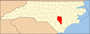
National Register of Historic Places listings in Sampson County, North Carolina
Map all coordinates using OpenStreetMap
Download coordinates as:
- KML
- GPX (all coordinates)
- GPX (primary coordinates)
- GPX (secondary coordinates)

This list includes properties and districts listed on the National Register of Historic Places in Sampson County, North Carolina. Click the "Map of all coordinates" link to the right to view a Google map of all properties and districts with latitude and longitude coordinates in the table below.[1]
Current listings
This National Park Service list is complete through NPS recent listings posted May 17, 2024.[2]
| [3] | Name on the Register[4] | Image | Date listed[5] | Location | City or town | Description |
|---|---|---|---|---|---|---|
| 1 | Beatty-Corbett House | Upload image | March 17, 1986 (#86000549) | SR 701 at SR 1200 34°33′11″N 78°15′09″W / 34.553056°N 78.2525°W / 34.553056; -78.2525 (Beatty-Corbett House) | Ivanhoe | |
| 2 | Bethune-Powell Buildings | 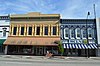 | March 17, 1986 (#86000580) | 118-120 E. Main St. 34°59′52″N 78°19′25″W / 34.997778°N 78.323611°W / 34.997778; -78.323611 (Bethune-Powell Buildings) | Clinton | |
| 3 | Asher W. Bizzell House | Upload image | May 21, 1986 (#86001125) | US 13 and SR 1845 35°12′35″N 78°24′58″W / 35.209664°N 78.416231°W / 35.209664; -78.416231 (Asher W. Bizzell House) | Rosin | |
| 4 | Black River Presbyterian and Ivanhoe Baptist Churches | 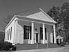 | March 17, 1986 (#86000550) | SR 1102 E of SR 1100 34°36′12″N 78°14′25″W / 34.603333°N 78.240278°W / 34.603333; -78.240278 (Black River Presbyterian and Ivanhoe Baptist Churches) | Ivanhoe | |
| 5 | Gen. Thomas Boykin House |  | March 17, 1986 (#86000551) | SR 1214 SW of SR 1222 34°57′43″N 78°22′26″W / 34.961944°N 78.373889°W / 34.961944; -78.373889 (Gen. Thomas Boykin House) | Clinton | |
| 6 | Thomas Bullard House | Upload image | August 25, 2014 (#14000522) | 386 Carry Bridge Rd. 34°59′45″N 78°34′01″W / 34.9957°N 78.5669°W / 34.9957; -78.5669 (Thomas Bullard House) | near Autryville | |
| 7 | Marion Butler Birthplace | Upload image | March 17, 1986 (#86000552) | NC 242 at SR 1414 35°02′25″N 78°27′59″W / 35.040278°N 78.466389°W / 35.040278; -78.466389 (Marion Butler Birthplace) | Salemburg | |
| 8 | Dan E. Caison Sr. House | Upload image | May 21, 1986 (#86001124) | Broad St. 34°57′11″N 78°30′53″W / 34.953056°N 78.514722°W / 34.953056; -78.514722 (Dan E. Caison Sr. House) | Roseboro | |
| 9 | Cherrydale | Upload image | March 17, 1986 (#86000554) | SR 1919 at SR 1952 35°01′06″N 78°12′06″W / 35.018333°N 78.201667°W / 35.018333; -78.201667 (Cherrydale) | Turkey | |
| 10 | Clear Run | Upload image | March 17, 1986 (#86000548) | NC 411 at Black River 34°44′23″N 78°15′56″W / 34.739722°N 78.265556°W / 34.739722; -78.265556 (Clear Run) | Clear Run | |
| 11 | Clinton Commercial Historic District |  | May 30, 2002 (#02000568) | Roughly bounded by Vance, Elizabeth, Wall, and Sampson Sts. 34°59′51″N 78°19′28″W / 34.997500°N 78.324444°W / 34.997500; -78.324444 (Clinton Commercial Historic District) | Clinton | |
| 12 | Clinton Depot | 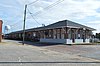 | March 17, 1986 (#86000555) | W. Elizabeth St. 34°59′46″N 78°19′27″W / 34.996111°N 78.324167°W / 34.996111; -78.324167 (Clinton Depot) | Clinton | |
| 13 | College Street Historic District |  | March 17, 1986 (#86000553) | 600-802 College St. 35°00′00″N 78°19′08″W / 35.000000°N 78.318889°W / 35.000000; -78.318889 (College Street Historic District) | Clinton | |
| 14 | Dell School Campus |  | May 21, 1986 (#86001126) | US 421 and SR 1003 34°48′05″N 78°12′54″W / 34.801389°N 78.215°W / 34.801389; -78.215 (Dell School Campus) | Delway | |
| 15 | Delta Farm | Upload image | March 17, 1986 (#86000556) | SR 1100 N of SR 1105 34°38′08″N 78°14′24″W / 34.635556°N 78.24°W / 34.635556; -78.24 (Delta Farm) | Ivanhoe | |
| 16 | William E. Faison House | Upload image | January 20, 2005 (#04001526) | NC 50 at jct. with NC 1757 (10901 Suttontown Rd.) 35°09′32″N 78°10′18″W / 35.158889°N 78.171667°W / 35.158889; -78.171667 (William E. Faison House) | Giddensville | |
| 17 | Graves-Stewart House |  | September 8, 1983 (#83001913) | 600 College St. 35°00′00″N 78°19′10″W / 35.000000°N 78.319583°W / 35.000000; -78.319583 (Graves-Stewart House) | Clinton | |
| 18 | Robert Herring House |  | March 17, 1986 (#86000557) | 216 Sampson St. 35°00′01″N 78°19′29″W / 35.000278°N 78.324722°W / 35.000278; -78.324722 (Robert Herring House) | Clinton | |
| 19 | Troy Herring House | Upload image | March 17, 1986 (#86000558) | Broad St. S of NC 24 34°57′25″N 78°31′00″W / 34.956944°N 78.516667°W / 34.956944; -78.516667 (Troy Herring House) | Roseboro | |
| 20 | Lewis Highsmith Farm | Upload image | March 17, 1986 (#86000559) | US 421 S of NC 41 34°42′43″N 78°11′17″W / 34.711944°N 78.188056°W / 34.711944; -78.188056 (Lewis Highsmith Farm) | Harrells | |
| 21 | Hollingsworth-Hines Farm | Upload image | March 17, 1986 (#86000547) | SR 1926 S of SR 1004 34°56′37″N 78°10′05″W / 34.943611°N 78.168056°W / 34.943611; -78.168056 (Hollingsworth-Hines Farm) | Turkey | |
| 22 | Howard-Royal House | Upload image | March 17, 1986 (#86000561) | 202 N. Main St. 35°00′58″N 78°30′12″W / 35.016111°N 78.503333°W / 35.016111; -78.503333 (Howard-Royal House) | Salemburg | |
| 23 | Howell-Butler House | Upload image | March 17, 1986 (#86000560) | Broad and McLamb Sts. 34°57′02″N 78°30′49″W / 34.950556°N 78.513611°W / 34.950556; -78.513611 (Howell-Butler House) | Roseboro | |
| 24 | Johnson Building |  | May 11, 2000 (#00000459) | 102-104 E. Main St. 34°59′51″N 78°19′26″W / 34.997500°N 78.323889°W / 34.997500; -78.323889 (Johnson Building) | Clinton | |
| 25 | Samuel Johnson House and Cemetery | Upload image | March 17, 1986 (#86000562) | SR 1157 S of SR 1004 34°49′09″N 78°19′31″W / 34.819167°N 78.325278°W / 34.819167; -78.325278 (Samuel Johnson House and Cemetery) | Ingold | |
| 26 | James Kerr House | Upload image | March 17, 1986 (#86000563) | SR 1005 S of SR 1007 34°39′03″N 78°15′31″W / 34.650833°N 78.258611°W / 34.650833; -78.258611 (James Kerr House) | Kerr | |
| 27 | Marcheston Killett Farm | Upload image | March 17, 1986 (#86000564) | SR 1222 N of US 701 34°56′31″N 78°20′21″W / 34.941944°N 78.339167°W / 34.941944; -78.339167 (Marcheston Killett Farm) | Clinton | |
| 28 | Marshall Kornegay House and Cemetery | Upload image | March 17, 1986 (#86000565) | SR 1725 and SR 1720 35°12′33″N 78°12′10″W / 35.209167°N 78.202778°W / 35.209167; -78.202778 (Marshall Kornegay House and Cemetery) | Suttontown | |
| 29 | James H. Lamb House | Upload image | March 17, 1986 (#86000566) | SR 1135 N of NC 411 34°47′10″N 78°20′23″W / 34.786111°N 78.339722°W / 34.786111; -78.339722 (James H. Lamb House) | Garland | |
| 30 | Lovett Lee House | Upload image | March 17, 1986 (#86000567) | SR 1725 and SR 1730 35°10′22″N 78°13′01″W / 35.172778°N 78.216944°W / 35.172778; -78.216944 (Lovett Lee House) | Giddensville | |
| 31 | Dr. James O. Matthews Office | Upload image | March 17, 1986 (#86000568) | SR 1960 S of SR 1004 34°51′53″N 78°15′12″W / 34.864722°N 78.253333°W / 34.864722; -78.253333 (Dr. James O. Matthews Office) | Taylors Bridge | |
| 32 | Fleet Matthis Farm | Upload image | March 17, 1986 (#86000569) | US 421 S of SR 1146 34°52′01″N 78°16′37″W / 34.866944°N 78.276944°W / 34.866944; -78.276944 (Fleet Matthis Farm) | Taylors Bridge | |
| 33 | Jonas McPhail House and Annie McPhail Store | Upload image | March 17, 1986 (#86000571) | US 13 E of SR 1845 35°12′32″N 78°24′58″W / 35.208919°N 78.416028°W / 35.208919; -78.416028 (Jonas McPhail House and Annie McPhail Store) | Rosin | |
| 34 | Murphy-Lamb House and Cemetery | Upload image | March 17, 1986 (#86000570) | SR 1135 S of US 701 34°47′46″N 78°21′36″W / 34.796111°N 78.36°W / 34.796111; -78.36 (Murphy-Lamb House and Cemetery) | Garland | |
| 35 | Oak Plain Presbyterian Church | Upload image | May 21, 1986 (#86001127) | SR 1943 S of SR 1945 34°50′17″N 78°10′10″W / 34.838056°N 78.169444°W / 34.838056; -78.169444 (Oak Plain Presbyterian Church) | Waycross | |
| 36 | Livingston Oates Farm | Upload image | March 17, 1986 (#86000572) | SR 1748 W of NC 403 35°04′12″N 78°15′28″W / 35.07°N 78.257778°W / 35.07; -78.257778 (Livingston Oates Farm) | Clinton | |
| 37 | Owen Family House and Cemetery | Upload image | March 17, 1986 (#86000573) | SR 1212 N of SR 1214 34°53′44″N 78°27′02″W / 34.895556°N 78.450556°W / 34.895556; -78.450556 (Owen Family House and Cemetery) | McDaniels | Destroyed[6] |
| 38 | Patrick-Carr-Herring House |  | January 14, 1993 (#92001791) | 226 McKoy St. 34°59′58″N 78°19′33″W / 34.999444°N 78.325833°W / 34.999444; -78.325833 (Patrick-Carr-Herring House) | Clinton | |
| 39 | Pigford House | Upload image | March 17, 1986 (#86000574) | SR 1751 S of US 701 35°02′40″N 78°19′29″W / 35.044444°N 78.324722°W / 35.044444; -78.324722 (Pigford House) | Clinton | |
| 40 | Pope House | Upload image | March 17, 1986 (#86000575) | SR 1146 N of SR 1145 34°54′51″N 78°18′30″W / 34.914167°N 78.308333°W / 34.914167; -78.308333 (Pope House) | Clinton | Burned[6] |
| 41 | Francis Pugh House |  | March 17, 1986 (#86000577) | SR 1751 at NC 403 35°00′37″N 78°18′08″W / 35.010278°N 78.302222°W / 35.010278; -78.302222 (Francis Pugh House) | Clinton | |
| 42 | Pugh-Boykin House |  | March 17, 1986 (#86000576) | 306 Elizabeth St. 34°59′41″N 78°19′31″W / 34.994722°N 78.325278°W / 34.994722; -78.325278 (Pugh-Boykin House) | Clinton | |
| 43 | Royal-Crumpler-Parker House |  | March 17, 1986 (#86000578) | 512 Sunset Ave. 34°59′52″N 78°19′56″W / 34.997778°N 78.332222°W / 34.997778; -78.332222 (Royal-Crumpler-Parker House) | Clinton | |
| 44 | Dr. John B. Seavey House and Cemetery | Upload image | May 21, 1986 (#86001128) | SR 1100 S of SR 1007 34°40′38″N 78°13′03″W / 34.677222°N 78.2175°W / 34.677222; -78.2175 (Dr. John B. Seavey House and Cemetery) | Harrells | |
| 45 | Dr. David Dickson Sloan Farm | Upload image | March 17, 1986 (#86000579) | US 701 N of the South River 34°46′12″N 78°23′41″W / 34.77°N 78.394722°W / 34.77; -78.394722 (Dr. David Dickson Sloan Farm) | Garland | |
| 46 | Thirteen Oaks | Upload image | June 7, 1990 (#90000879) | Jct. of US 13 and SR 1647 35°13′07″N 78°23′50″W / 35.218611°N 78.397222°W / 35.218611; -78.397222 (Thirteen Oaks) | Newton Grove | |
| 47 | West Main-North Chesnutt Streets Historic District |  | March 17, 1986 (#86000546) | Roughly N. Chesnutt, Fayetteville, and Williams Sts. between W. Main and Margaret Sts. 34°59′47″N 78°19′33″W / 34.996389°N 78.325833°W / 34.996389; -78.325833 (West Main-North Chesnutt Streets Historic District) | Clinton | |
| 48 | Isaac Williams House | Upload image | March 1, 1984 (#84002523) | NC 55; also NC 55 at its junction with NC 50 35°14′52″N 78°22′55″W / 35.247778°N 78.381944°W / 35.247778; -78.381944 (Isaac Williams House) | Newton Grove | Second location represents a boundary increase of June 12, 1989 |
| 49 | John E. Wilson House | Upload image | March 17, 1986 (#86000545) | SR 1631 at SR 1630 35°15′37″N 78°30′29″W / 35.260278°N 78.508056°W / 35.260278; -78.508056 (John E. Wilson House) | Dunn |
See also
Wikimedia Commons has media related to National Register of Historic Places in Sampson County, North Carolina.
- National Register of Historic Places listings in North Carolina
- List of National Historic Landmarks in North Carolina
References
- ^ The latitude and longitude information provided in this table was derived originally from the National Register Information System, which has been found to be fairly accurate for about 99% of listings. Some locations in this table may have been corrected to current GPS standards.
- ^ National Park Service, United States Department of the Interior, "National Register of Historic Places: Weekly List Actions", retrieved May 17, 2024.
- ^ Numbers represent an alphabetical ordering by significant words. Various colorings, defined here, differentiate National Historic Landmarks and historic districts from other NRHP buildings, structures, sites or objects.
- ^ "National Register Information System". National Register of Historic Places. National Park Service. April 24, 2008.
- ^ The eight-digit number below each date is the number assigned to each location in the National Register Information System database, which can be viewed by clicking the number.
- ^ a b "North Carolina Listings in the National Register of Historic Places by County". North Carolina State Historic Preservation Office. 22 October 2008. Archived from the original on 30 November 2012. Retrieved 14 July 2009.
- v
- t
- e

by county
- Alamance
- Alexander
- Alleghany
- Anson
- Ashe
- Avery
- Beaufort
- Bertie
- Bladen
- Brunswick
- Buncombe
- Burke
- Cabarrus
- Caldwell
- Camden
- Carteret
- Caswell
- Catawba
- Chatham
- Cherokee
- Chowan
- Clay
- Cleveland
- Columbus
- Craven
- Cumberland
- Currituck
- Dare
- Davidson
- Davie
- Duplin
- Durham
- Edgecombe
- Forsyth
- Franklin
- Gaston
- Gates
- Graham
- Granville
- Greene
- Guilford
- Halifax
- Harnett
- Haywood
- Henderson
- Hertford
- Hoke
- Hyde
- Iredell
- Jackson
- Johnston
- Jones
- Lee
- Lenoir
- Lincoln
- Macon
- Madison
- Martin
- McDowell
- Mecklenburg
- Mitchell
- Montgomery
- Moore
- Nash
- New Hanover
- Northampton
- Onslow
- Orange
- Pamlico
- Pasquotank
- Pender
- Perquimans
- Person
- Pitt
- Polk
- Randolph
- Richmond
- Robeson
- Rockingham
- Rowan
- Rutherford
- Sampson
- Scotland
- Stanly
- Stokes
- Surry
- Swain
- Transylvania
- Tyrrell
- Union
- Vance
- Wake
- Warren
- Washington
- Watauga
- Wayne
- Wilkes
- Wilson
- Yadkin
- Yancey
| |
|---|---|
| Topics | |
| Lists by state |
|
| Lists by insular areas | |
| Lists by associated state | |
| Other areas | |
| Related | |
| |