National Register of Historic Places listings in Roanoke, Virginia

This is a list of the National Register of Historic Places listings in Roanoke, Virginia.
This is intended to be a complete list of the properties and districts on the National Register of Historic Places in the independent city of Roanoke, Virginia, United States. The locations of National Register properties and districts for which the latitude and longitude coordinates are included below, may be seen in an online map.[1]
There are 55 properties and districts listed on the National Register in the city. Another property was once listed but has been removed.
This National Park Service list is complete through NPS recent listings posted May 24, 2024.[2]
Map all coordinates using OpenStreetMap
Download coordinates as:
- KML
- GPX (all coordinates)
- GPX (primary coordinates)
- GPX (secondary coordinates)
Current listings
| [3] | Name on the Register[4] | Image | Date listed[5] | Location | Description |
|---|---|---|---|---|---|
| 1 | American Viscose Plant Historic District |  | August 6, 2019 (#100004260) | Roughly 9th St., SE., Industry Ave., SE., River Ave., SE., and Progressive Dr., SE. 37°15′20″N 79°55′20″W / 37.255556°N 79.922222°W / 37.255556; -79.922222 (American Viscose Plant Historic District) | |
| 2 | Apartment Building on Windsor Avenue and Brunswick St. |  | August 23, 2010 (#10000559) | 2049 Windsor Ave., SW. 37°15′47″N 79°58′49″W / 37.263056°N 79.980278°W / 37.263056; -79.980278 (Apartment Building on Windsor Avenue and Brunswick St.) | |
| 3 | Belle Aire |  | April 15, 1975 (#75002034) | U.S. Route 11 37°15′49″N 80°01′03″W / 37.263611°N 80.0175°W / 37.263611; -80.0175 (Belle Aire) | |
| 4 | Belmont Historic District |  | April 15, 2019 (#100003618) | Albemarle, Bullitt, Elm, Jamison, Dale, Campbell, Cedar Bluff, Church, Highland, Mountain, Stewart, Tazewell, and White Aves., SE., and 4th-11th Sts., SE. 37°16′12″N 79°55′45″W / 37.270000°N 79.929167°W / 37.270000; -79.929167 (Belmont Historic District) | |
| 5 | Belmont Methodist-Episcopal Church |  | August 18, 2011 (#11000551) | 806 Jamison Ave., SE. 37°16′09″N 79°55′49″W / 37.269167°N 79.930278°W / 37.269167; -79.930278 (Belmont Methodist-Episcopal Church) | |
| 6 | Boxley Building |  | March 8, 1984 (#84003587) | 416 Jefferson St., SW. 37°16′12″N 79°56′25″W / 37.270000°N 79.940278°W / 37.270000; -79.940278 (Boxley Building) | |
| 7 | Boxley-Sprinkle House |  | November 27, 2004 (#04001275) | 2611 Crystal Spring Ave. 37°14′39″N 79°57′01″W / 37.244167°N 79.950278°W / 37.244167; -79.950278 (Boxley-Sprinkle House) | |
| 8 | Buena Vista |  | July 30, 1974 (#74002244) | Penmar Ave. and 9th St. 37°15′50″N 79°55′23″W / 37.263889°N 79.923056°W / 37.263889; -79.923056 (Buena Vista) | |
| 9 | Burrell Memorial Hospital |  | September 22, 2003 (#03000450) | 611 McDowell St. 37°16′57″N 79°56′58″W / 37.282500°N 79.949306°W / 37.282500; -79.949306 (Burrell Memorial Hospital) | |
| 10 | Campbell Avenue Complex | 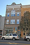 | January 24, 1991 (#90002171) | 118-128 Campbell Ave., SW. 37°16′18″N 79°56′37″W / 37.271667°N 79.943611°W / 37.271667; -79.943611 (Campbell Avenue Complex) | |
| 11 | Carlin's Amoco Station |  | November 20, 2012 (#12000968) | 1721 Williamson Rd., NE. 37°17′17″N 79°56′00″W / 37.288056°N 79.933472°W / 37.288056; -79.933472 (Carlin's Amoco Station) | |
| 12 | City of Roanoke Fire Station No. 5 |  | November 18, 2011 (#11000838) | 216 12th St., NW. 37°16′45″N 79°57′32″W / 37.279167°N 79.958889°W / 37.279167; -79.958889 (City of Roanoke Fire Station No. 5) | |
| 13 | The Coffee Pot |  | May 31, 1996 (#96000575) | 2902 Brambleton Ave., SW. 37°14′36″N 79°59′28″W / 37.243333°N 79.991111°W / 37.243333; -79.991111 (The Coffee Pot) | |
| 14 | Colonial National Bank |  | December 17, 1983 (#83004035) | 202-208 Jefferson St. 37°16′18″N 79°56′25″W / 37.271667°N 79.940278°W / 37.271667; -79.940278 (Colonial National Bank) | |
| 15 | Colony House Motor Lodge |  | March 8, 2023 (#100008648) | 3560 Franklin Rd. SW 37°14′11″N 79°58′09″W / 37.2364°N 79.9691°W / 37.2364; -79.9691 (Colony House Motor Lodge) | |
| 16 | Crystal Spring Steam Pumping Station |  | May 23, 1980 (#80004220) | 2016 Lake St., SE 37°14′59″N 79°56′38″W / 37.249722°N 79.943750°W / 37.249722; -79.943750 (Crystal Spring Steam Pumping Station) | |
| 17 | English Gardens Apartments |  | August 17, 2022 (#100008022) | 2325, 2331, 2333, 2339, 2343, 2345, 2349 Memorial Ave. SW, 1208, 1218, 1222 Fauquier St. SW, 2324, 2330, 2332, 2336, 2340, 2346, 2352 Denniston Ave. SW 37°16′05″N 79°59′13″W / 37.2680°N 79.9869°W / 37.2680; -79.9869 (English Gardens Apartments) | |
| 18 | Fire Station No. 1 |  | May 7, 1973 (#73002224) | 13 E. Church Ave. 37°16′13″N 79°56′24″W / 37.270278°N 79.940000°W / 37.270278; -79.940000 (Fire Station No. 1) | |
| 19 | First National Bank |  | June 14, 1982 (#82004591) | 101 S. Jefferson St. 37°16′20″N 79°56′27″W / 37.272361°N 79.940833°W / 37.272361; -79.940833 (First National Bank) | |
| 20 | Gainsboro Branch of the Roanoke City Public Library | 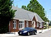 | December 2, 1996 (#96001448) | 15 Patton Ave., NW. 37°16′38″N 79°56′28″W / 37.277222°N 79.941111°W / 37.277222; -79.941111 (Gainsboro Branch of the Roanoke City Public Library) | |
| 21 | Gainsboro Historic District |  | November 16, 2005 (#05001276) | Bounded by Wells, Centre, the First Street Bridge, Gilmer, Commonwealth, N. Jefferson, 2nd., Patton, Harrison, and other streets 37°16′36″N 79°56′40″W / 37.276667°N 79.944444°W / 37.276667; -79.944444 (Gainsboro Historic District) | |
| 22 | Grandin Road Commercial Historic District |  | November 27, 2002 (#02001450) | Grandin Rd., SW., and Memorial Ave. 37°15′57″N 79°58′37″W / 37.265833°N 79.976944°W / 37.265833; -79.976944 (Grandin Road Commercial Historic District) | |
| 23 | Harrison School |  | September 9, 1982 (#82004592) | 523 Harrison Ave., NW. 37°16′46″N 79°56′53″W / 37.279444°N 79.948056°W / 37.279444; -79.948056 (Harrison School) | |
| 24 | Henry Street Historic District | 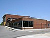 | November 27, 2004 (#04001276) | 100 block of Henry St., NW. 37°16′28″N 79°56′32″W / 37.274444°N 79.942222°W / 37.274444; -79.942222 (Henry Street Historic District) | |
| 25 | Patrick Henry Hotel |  | July 3, 1991 (#91000829) | 617 S. Jefferson St. 37°16′07″N 79°56′27″W / 37.268611°N 79.940833°W / 37.268611; -79.940833 (Patrick Henry Hotel) | |
| 26 | Hotel Roanoke |  | February 16, 1996 (#96000033) | 110 Shenandoah Ave. 37°16′28″N 79°56′22″W / 37.274444°N 79.939444°W / 37.274444; -79.939444 (Hotel Roanoke) | |
| 27 | Huntingdon |  | November 8, 1991 (#91001598) | 320 Huntingdon Boulevard 37°18′28″N 79°56′15″W / 37.307778°N 79.937500°W / 37.307778; -79.937500 (Huntingdon) | |
| 28 | H. L. Lawson & Son Warehouse |  | September 5, 2008 (#08000830) | 631 Campbell Ave., SE. 37°16′20″N 79°56′00″W / 37.272222°N 79.933333°W / 37.272222; -79.933333 (H. L. Lawson & Son Warehouse) | |
| 29 | Lone Oaks |  | April 11, 1973 (#73002054) | 3402 Grandin Rd. Ext., SW. 37°14′57″N 80°00′18″W / 37.249167°N 80.005000°W / 37.249167; -80.005000 (Lone Oaks) | |
| 30 | Melrose-Rugby Historic District |  | August 27, 2013 (#13000645) | Mercer, Grayson, and Carroll Aves., NW., Rugby Boulevard, NW., and 10th, 11th, 12th, 13th, and 14th Sts., NW. 37°17′14″N 79°57′16″W / 37.287222°N 79.954444°W / 37.287222; -79.954444 (Melrose-Rugby Historic District) | |
| 31 | Monterey |  | July 30, 1974 (#74002146) | Tinker Creek Lane, NE. 37°18′14″N 79°55′01″W / 37.303889°N 79.916944°W / 37.303889; -79.916944 (Monterey) | |
| 32 | Mount Moriah Baptist Church And Cemetery |  | September 8, 1994 (#94001092) | 3521 E. Orange Ave. 37°18′16″N 79°53′27″W / 37.304306°N 79.890833°W / 37.304306; -79.890833 (Mount Moriah Baptist Church And Cemetery) | |
| 33 | Mountain View |  | October 31, 1980 (#80004221) | 714 13th St., SW. 37°16′10″N 79°57′50″W / 37.269444°N 79.963889°W / 37.269444; -79.963889 (Mountain View) | Also known as the Junius Fishburn House |
| 34 | Norfolk & Western Class J No. 611 Locomotive |  | February 8, 2024 (#100009961) | 303 Norfolk Avenue SW 37°16′22″N 79°56′50″W / 37.2729°N 79.9472°W / 37.2729; -79.9472 (Norfolk & Western Class J No. 611 Locomotive) | |
| 35 | Norfolk and Western Railway Company Historic District |  | January 27, 1999 (#99000076) | 88 and 108 Jefferson St., NW., and 209 Shenandoah Ave. 37°16′26″N 79°56′28″W / 37.273889°N 79.941111°W / 37.273889; -79.941111 (Norfolk and Western Railway Company Historic District) | |
| 36 | Norfolk & Western Railway Freight Station |  | November 21, 2012 (#12000969) | 303 Norfolk Ave. 37°16′23″N 79°56′46″W / 37.273056°N 79.946111°W / 37.273056; -79.946111 (Norfolk & Western Railway Freight Station) | Now serves as the location for the Virginia Museum of Transportation |
| 37 | Riverland Historic District |  | August 27, 2013 (#13000646) | Laural, Primrose, Whitman, and Ivy Sts., Riverland Rd., and Walnut and Arbutus Aves. 37°15′30″N 79°56′03″W / 37.258333°N 79.934167°W / 37.258333; -79.934167 (Riverland Historic District) | |
| 38 | Roanoke Apartments | 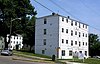 | November 9, 2006 (#06000759) | 1402 Maiden Lane 37°15′50″N 79°58′07″W / 37.263889°N 79.968611°W / 37.263889; -79.968611 (Roanoke Apartments) | |
| 39 | Roanoke City Firehouse No. 6 |  | January 24, 1991 (#90002162) | 1015 Jamison Ave., SE. 37°16′11″N 79°55′34″W / 37.269722°N 79.926111°W / 37.269722; -79.926111 (Roanoke City Firehouse No. 6) | |
| 40 | Roanoke City Health Center |  | May 12, 2016 (#16000263) | 515 8th St., SW. 37°16′14″N 79°57′21″W / 37.270556°N 79.955833°W / 37.270556; -79.955833 (Roanoke City Health Center) | |
| 41 | Roanoke City Market Historic District |  | April 20, 1983 (#83003312) | Roughly bounded by Williamson Rd., Norfolk Ave., S. Jefferson St., and Church Ave.; also 302 Campbell Ave., SE., and 9 Church Ave., SE. 37°16′18″N 79°56′21″W / 37.271667°N 79.939167°W / 37.271667; -79.939167 (Roanoke City Market Historic District) | Second set of addresses represents a boundary increase of June 6, 2002 |
| 42 | Roanoke Downtown Historic District |  | September 14, 2002 (#02000978) | Roughly bounded by 3rd St., Norfolk Ave., Jefferson St., and Bullitt Ave.; also 310-324 Salem Ave., SW.; also the 300-400 blocks of Church and 300-400 blocks of Luck Aves., SW., 600-700 blocks of S. Jefferson St., and 401 3rd and 502 5th Sts., SW. 37°16′16″N 79°56′33″W / 37.271111°N 79.942500°W / 37.271111; -79.942500 (Roanoke Downtown Historic District) | Second and third sets of boundaries represent boundary increases of March 29, 2007 and August 27, 2013 respectively |
| 43 | Roanoke River and Railroad Historic District |  | December 24, 2013 (#13000994) | Albemarle and Walnut Aves., SE., Williamson Rd., SE., and 4th and Jefferson Sts., SE. 37°15′35″N 79°56′20″W / 37.259722°N 79.938889°W / 37.259722; -79.938889 (Roanoke River and Railroad Historic District) | |
| 44 | Roanoke Star |  | November 15, 1999 (#99001375) | Mill Mountain 37°15′03″N 79°55′57″W / 37.250833°N 79.932500°W / 37.250833; -79.932500 (Roanoke Star) | |
| 45 | Roanoke Warehouse Historic District |  | March 29, 1983 (#83003313) | 109-133 Norfolk Ave., SW. 37°16′23″N 79°56′36″W / 37.273056°N 79.943333°W / 37.273056; -79.943333 (Roanoke Warehouse Historic District) | |
| 46 | Tayloe Rogers House | 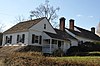 | November 21, 2012 (#12000970) | 1542 Electric Rd., SW. 37°15′25″N 80°02′01″W / 37.256944°N 80.033611°W / 37.256944; -80.033611 (Tayloe Rogers House) | |
| 47 | St. Andrew's Roman Catholic Church |  | May 7, 1973 (#73002225) | 631 N. Jefferson St. 37°16′42″N 79°56′24″W / 37.278333°N 79.940000°W / 37.278333; -79.940000 (St. Andrew's Roman Catholic Church) | |
| 48 | St. John's Episcopal Church |  | August 23, 1991 (#91001083) | Southwestern corner of Jefferson St. and Elm Ave. 37°16′00″N 79°56′28″W / 37.266667°N 79.941111°W / 37.266667; -79.941111 (St. John's Episcopal Church) | |
| 49 | Salem Avenue-Roanoke Automotive Commercial Historic District |  | August 8, 2007 (#07000807) | Generally Salem Ave., Rorer Ave., and Campbell Ave. between 3rd and 6th Sts.; also the 400-600 blocks of Campbell Ave.; also the 700 block of Patterson Ave. 37°16′21″N 79°56′58″W / 37.272500°N 79.949444°W / 37.272500; -79.949444 (Salem Avenue-Roanoke Automotive Commercial Historic District) | Second and third sets of boundaries represent boundary increases of May 15, 2008 and October 22, 2014 respectively |
| 50 | Salvation Army Citadel |  | August 7, 2020 (#100005429) | 821 Salem Ave., SW. 37°16′25″N 79°57′23″W / 37.273611°N 79.956394°W / 37.273611; -79.956394 (Salvation Army Citadel) | |
| 51 | Southwest Historic District | 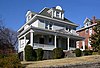 | June 19, 1985 (#85001349) | Roughly bounded by Salem Ave., Jefferson St., the Roanoke River, and 20th St.; also roughly bounded by Westview, Westport, Salem, Jackson, Norfolk, Rorer, Campbell, Marshall, Day, Jefferson, and Clark Aves., the Roanoke River, and 13th and 21st Sts. 37°16′08″N 79°57′20″W / 37.268889°N 79.955556°W / 37.268889; -79.955556 (Southwest Historic District) | |
| 52 | Villa Heights |  | June 4, 2018 (#100002532) | 2750 Hoover St. 37°17′33″N 79°58′44″W / 37.292500°N 79.978889°W / 37.292500; -79.978889 (Villa Heights) | |
| 53 | Virginia Can Company-S.H. Heironimus Warehouse |  | February 22, 2006 (#06000067) | 315 Albemarle Ave., SE. 37°15′47″N 79°56′16″W / 37.263056°N 79.937778°W / 37.263056; -79.937778 (Virginia Can Company-S.H. Heironimus Warehouse) | Built beside the Virginian Railway in 1912 to house Roanoke's first tin can company; later a clothing factory and then a department store warehouse[6] |
| 54 | Virginian Railway Passenger Station |  | May 22, 2003 (#03000456) | 1402 Jefferson St., SE. 37°15′35″N 79°56′28″W / 37.259722°N 79.941111°W / 37.259722; -79.941111 (Virginian Railway Passenger Station) | |
| 55 | Wasena Historic District | 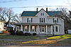 | January 3, 2012 (#11000984) | Wiley Dr., Winchester, Winona, Wasena, Howbert, Valley, Hamilton, Kerns, Floyd, and Summit Aves., Brighton Rd. 37°15′48″N 79°57′36″W / 37.263333°N 79.960000°W / 37.263333; -79.960000 (Wasena Historic District) |
Former listing
| [3] | Name on the Register | Image | Date listed | Date removed | Location | City or town | Description |
|---|---|---|---|---|---|---|---|
| 1 | First Baptist Church | Upload image | December 6, 1990 (#90001840) | March 19, 2001 | 407 N. Jefferson Street | Roanoke | Destroyed by fire April 1995 |
See also
Wikimedia Commons has media related to National Register of Historic Places in Roanoke, Virginia.
- List of National Historic Landmarks in Virginia
- National Register of Historic Places listings in Virginia
- National Register of Historic Places listings in Roanoke County, Virginia
- National Register of Historic Places listings in Salem, Virginia
References
- ^ The latitude and longitude information provided in this table was derived originally from the National Register Information System, which has been found to be fairly accurate for about 99% of listings. Some locations in this table may have been corrected to current GPS standards.
- ^ National Park Service, United States Department of the Interior, "National Register of Historic Places: Weekly List Actions", retrieved May 24, 2024.
- ^ a b Numbers represent an alphabetical ordering by significant words. Various colorings, defined here, differentiate National Historic Landmarks and historic districts from other NRHP buildings, structures, sites or objects.
- ^ "National Register Information System". National Register of Historic Places. National Park Service. April 24, 2008.
- ^ The eight-digit number below each date is the number assigned to each location in the National Register Information System database, which can be viewed by clicking the number.
- ^ Kelley, Brian (January 25, 2011). "Old Heironimus warehouse in Southeast Roanoke gets a new lift, new life". The Roanoke Times. Roanoke, Virginia. Archived from the original on September 9, 2012. Retrieved January 26, 2011.
- v
- t
- e
by county
- Accomack
- Albemarle
- Alleghany
- Amelia
- Amherst
- Appomattox
- Arlington
- Augusta
- Bath
- Bedford
- Bland
- Botetourt
- Brunswick
- Buchanan
- Buckingham
- Campbell
- Caroline
- Carroll
- Charles City
- Charlotte
- Chesterfield
- Clarke
- Craig
- Culpeper
- Cumberland
- Dickenson
- Dinwiddie
- Essex
- Fairfax
- Fauquier
- Floyd
- Fluvanna
- Franklin
- Frederick
- Giles
- Gloucester
- Goochland
- Grayson
- Greene
- Greensville
- Halifax
- Hanover
- Henrico
- Henry
- Highland
- Isle Of Wight
- James City
- King and Queen
- King George
- King William
- Lancaster
- Lee
- Loudoun
- Louisa
- Lunenburg
- Madison
- Mathews
- Mecklenburg
- Middlesex
- Montgomery
- Nelson
- New Kent
- Northampton
- Northumberland
- Nottoway
- Orange
- Page
- Patrick
- Pittsylvania
- Powhatan
- Prince Edward
- Prince George
- Prince William
- Pulaski
- Rappahannock
- Richmond
- Roanoke
- Rockbridge
- Rockingham
- Russell
- Scott
- Shenandoah
- Smyth
- Southampton
- Spotsylvania
- Stafford
- Surry
- Sussex
- Tazewell
- Warren
- Washington
- Westmoreland
- Wise
- Wythe
- York

by city
- Alexandria
- Bristol
- Buena Vista
- Charlottesville
- Chesapeake
- Colonial Heights
- Covington
- Danville
- Emporia
- Fairfax
- Falls Church
- Franklin
- Fredericksburg
- Galax
- Hampton
- Harrisonburg
- Hopewell
- Lexington
- Lynchburg
- Manassas
- Manassas Park
- Martinsville
- Newport News
- Norfolk
- Norton
- Petersburg
- Poquoson (no listings)
- Portsmouth
- Radford
- Richmond
- Roanoke
- Salem
- Staunton
- Suffolk
- Virginia Beach
- Waynesboro
- Williamsburg
- Winchester


