Mount Guna
Mountain and shield volcano in Amhara Region, Ethiopia

Guna
Location in Ethiopia
Amhara Region, Ethiopia
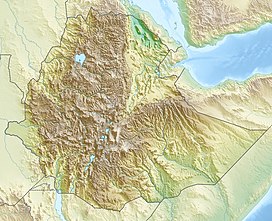
Mount Guna (Amharic: ጉና ተራራ, Guna Terara) is a mountain and shield volcano located near the cities of Nefas Mewcha and Debre Tabor, in the northern Amhara Region of Ethiopia. It is the highest point in the South Gondar Zone, with an elevation of 4,120 metres (13,517 ft) above sea level.[2]
Mount Guna forms part of the divide between the drainage basins of the Abay and the Tekezé rivers. It is the origin of the Gumara, Rib, and other rivers, which flow into Lake Tana and Yikalo, Mebela, Goleye and other rivers, which flow into the Tekezé river.
 africa portal

See also
References
- ^ a b c "Africa Ultra-Prominences" Peaklist.org. Retrieved 2012-01-15.
- ^ "Guna Terara, Ethiopia" Peakbagger.com. Retrieved 2012-01-15.
- v
- t
- e


